Notice of Meeting:
I hereby give notice that an ordinary meeting of the
Infrastructure Services and Networks Committee will be held on:
Date: Monday
14 August 2017
Time: 1.00
pm
Venue: Edinburgh
Room, Municipal Chambers,
The Octagon, Dunedin
Sue Bidrose
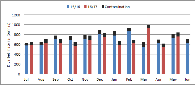
Infrastructure Services and Networks Committee
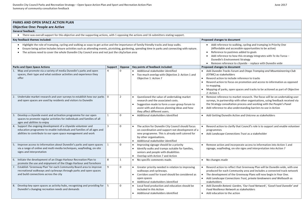
PUBLIC AGENDA
|
Chairperson
|
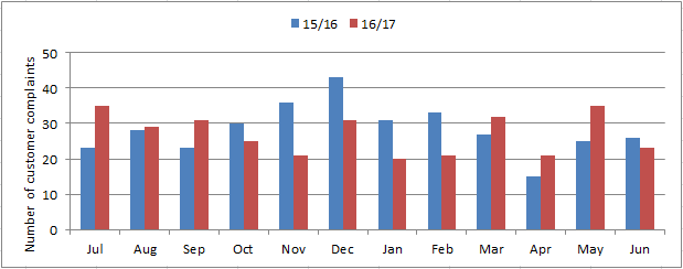
Cr Kate Wilson
|
|
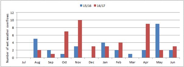
|
Deputy Chairperson
|
Cr Jim O'Malley
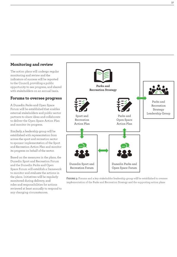
|
|
|
Members
|
Cr David Benson-Pope
|
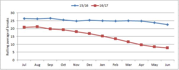
Mayor Dave Cull
|
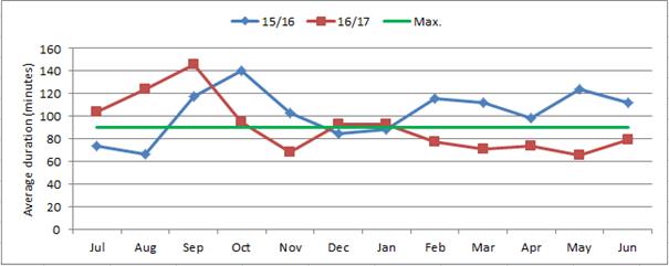
|
|
Cr Rachel Elder
|
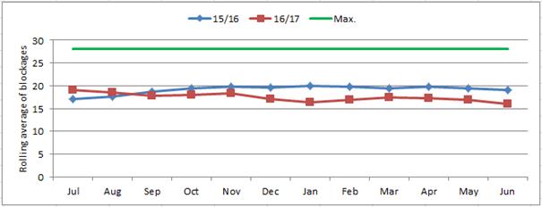
Cr Christine Garey
|
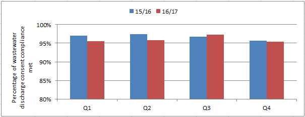
|
|
Cr Doug Hall
|
Cr Aaron Hawkins
|
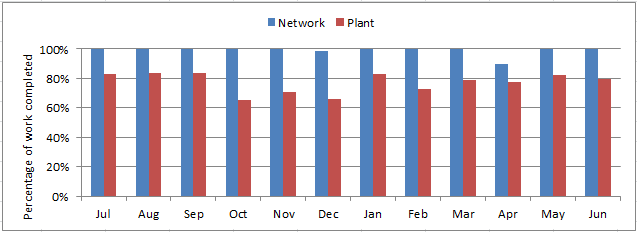
|
|
Cr Marie Laufiso
|
Cr Mike Lord
|
|
|
Cr Damian Newell
|
Cr Chris Staynes
|
|
|
Cr Conrad Stedman
|
Cr Lee Vandervis
|
|
|
Cr Andrew Whiley
|
|
Senior Officer Ruth
Stokes, General Manager Infrastructure and Networks
Governance Support Officer Wendy
Collard
Wendy Collard
Governance Support Officer
Telephone: 03 477 4000
Wendy.Collard@dcc.govt.nz
www.dunedin.govt.nz
Note: Reports
and recommendations contained in this agenda are not to be considered as
Council policy until adopted.
|
Infrastructure Services and
Networks Committee
14 August 2017
|
|
ITEM TABLE OF CONTENTS PAGE
1 Public
Forum 4
1.1 Proposal to name a new road off Riccarton
Road East 4
2 Apologies 4
3 Confirmation
of Agenda 4
4 Declaration
of Interest 5
Part
A Reports (Committee has power to decide these matters)
5 3
Waters Activity Report for the Quarter Ending 30 June 2017 15
6 Solid
Waste Activity Report for the Quarter Ending 30 June 2017 25
7 Parks
and Recreation Activity Report for Year Ending 30 June 2017 32
8 Parks
and Recreation Strategy 41
9 Proposal
to name a new road off Riccarton Road East 101
10 Proposal
to Name a New Private Way off Glendermid Close, Sawyers Bay. 107
11 Proposal
to name a new private way off Brighton Road, Waldronville. 111
12 Amendment
to Road Naming Policy 116
13 Transport
Activity Report for the Quarter Ended 30 June 2017 136
14 Proposed
Consultation Dunedin City Speed Limits Bylaw Amendment 8 146
15 Update
on the NZTA Speed Management Guidelines 194
16 Dunedin
Urban Cycleways 241
17 Items
for Consideration by the Chair
|
Infrastructure Services and
Networks Committee
14 August 2017
|
|
1 Public
Forum
1.1 Proposal to name a new road
off Riccarton Road East
On behalf of AKGO Ltd, Amin Osama from Gallaway Cook Allan
wishes to address the meeting concerning the proposal to name a new road off
Riccarton Road East.
2 Apologies
An apology has been received from Cr
Lee Vandervis.
That the Committee:
Accepts the apology from Cr
Lee Vandervis.
3 Confirmation
of agenda
Note:
Any additions must be approved by resolution with an explanation as to why they
cannot be delayed until a future meeting.
RECOMMENDATIONS
That the
Committee:
Confirms the agenda with
the following alteration:
- In
regard to Standing Order 2.1, Option C be adopted in relation to moving and
seconding and speaking to amendments
|
Infrastructure Services and
Networks Committee
14 August 2017
|
|
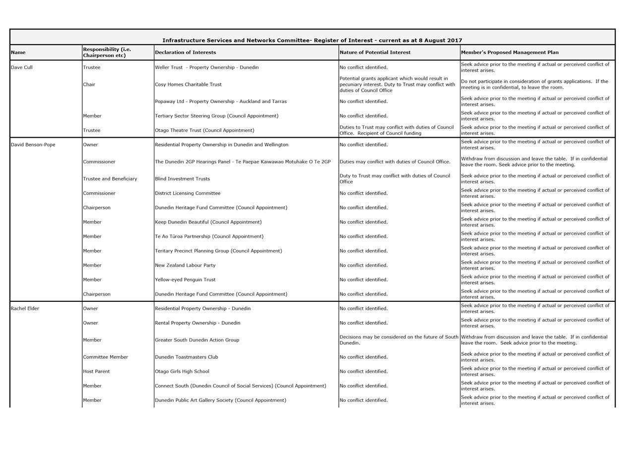
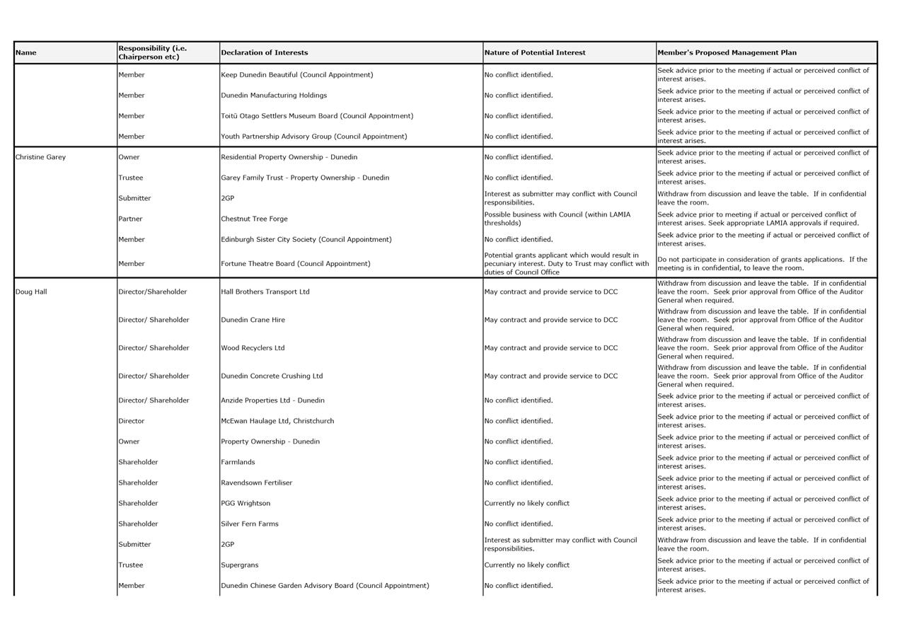
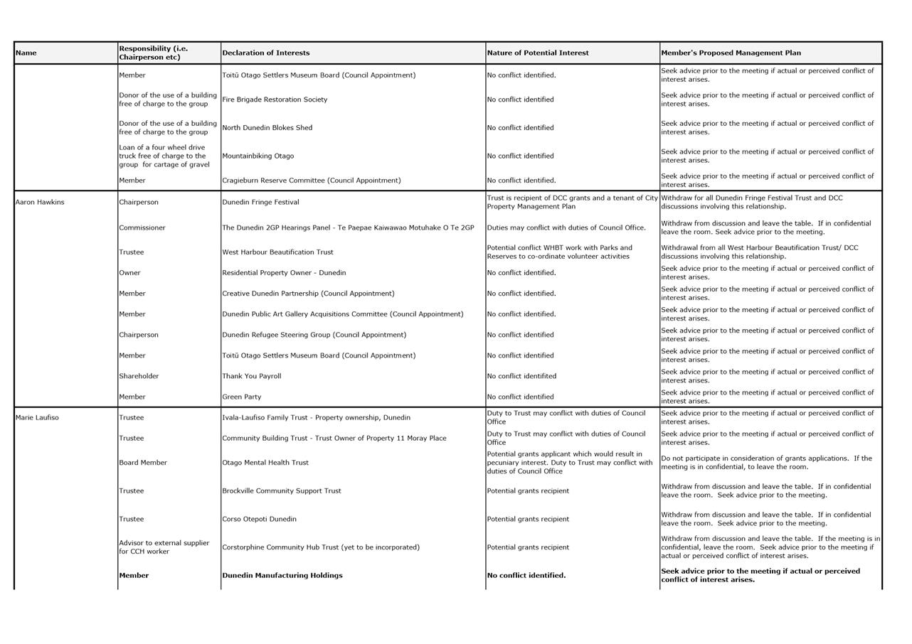
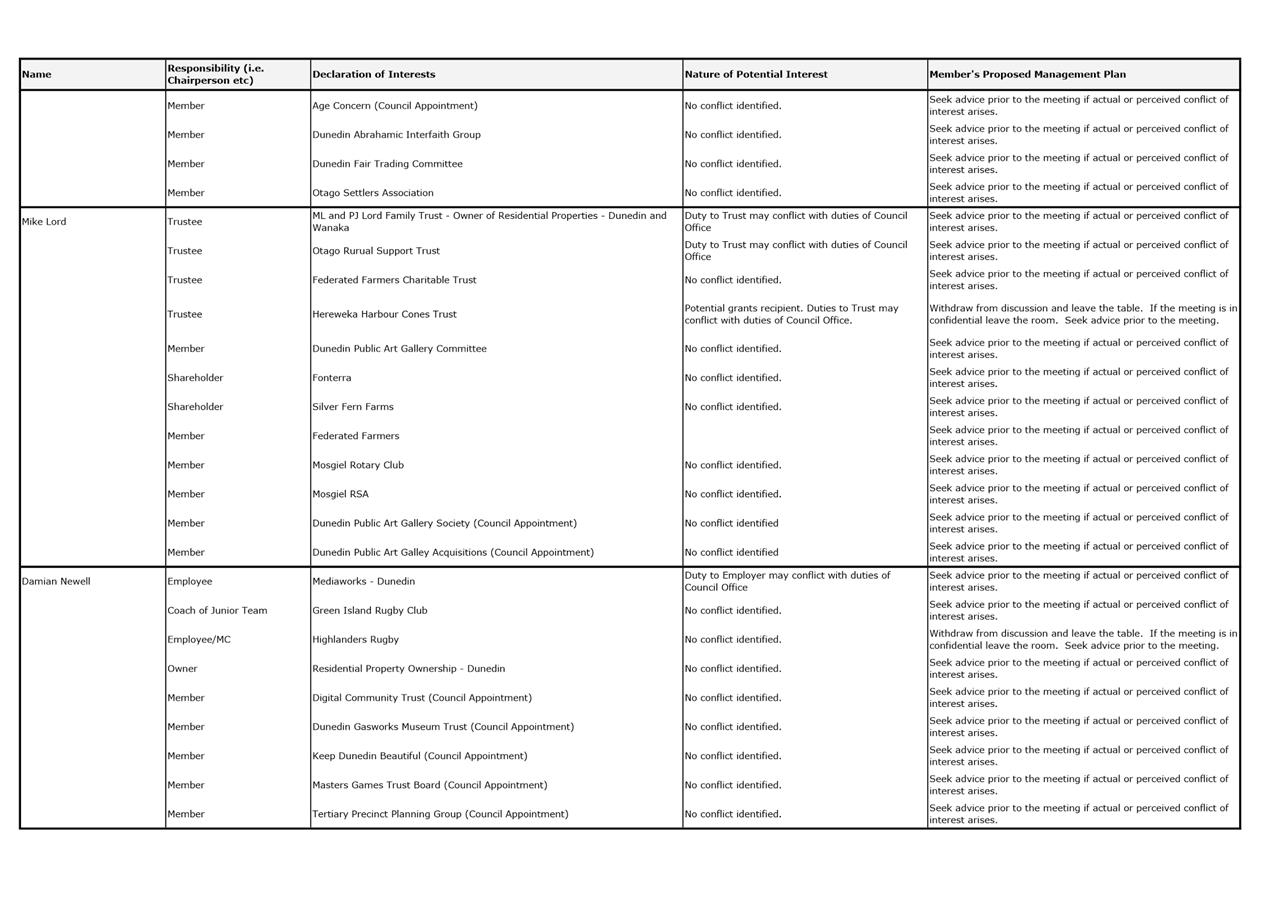
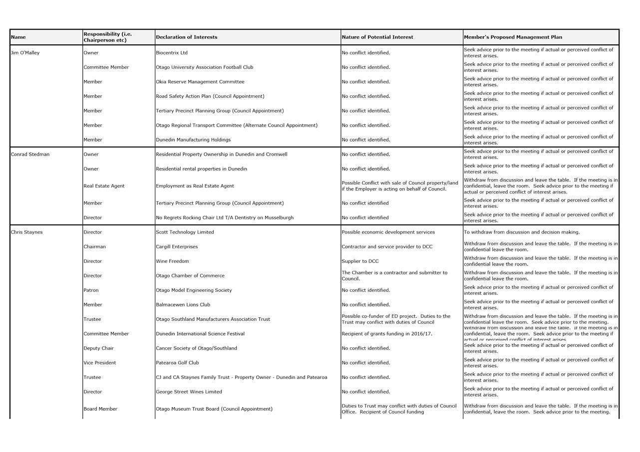
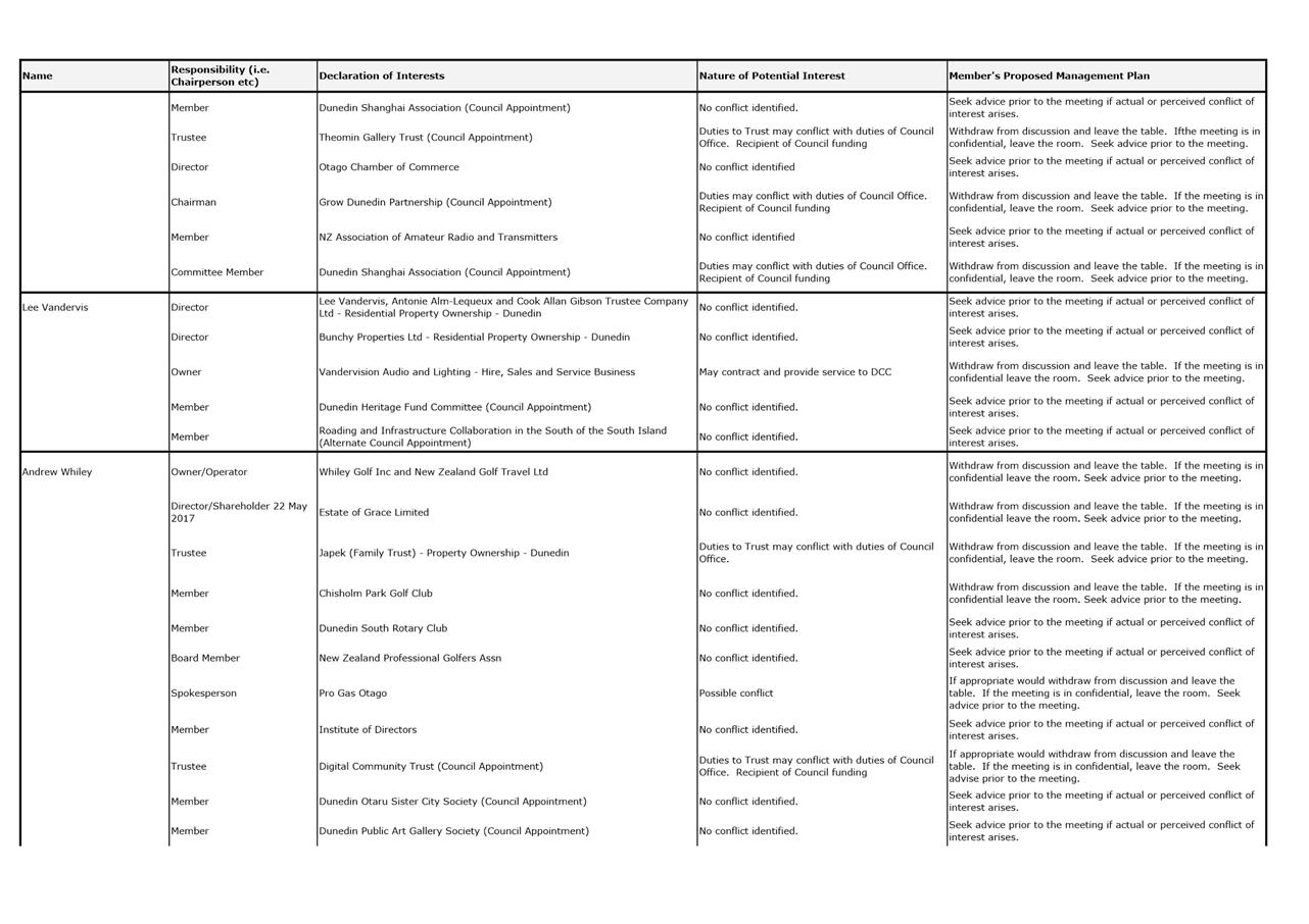
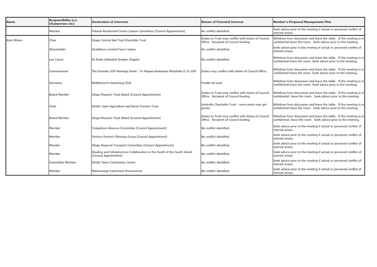
Declaration of Interest
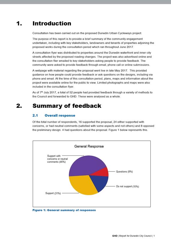
EXECUTIVE SUMMARY
1. Members are reminded of the need
to stand aside from decision-making when a conflict arises between their role
as an elected representative and any private or other external interest they
might have.
2. Elected
members are reminded to update their register of interests as
soon as practicable, including amending the register at this meeting if
necessary.
|
RECOMMENDATIONS
That the Committee:
a) Notes/Amends
if necessary the Elected Members' Interest Register attached as Attachment A;
and
b) Confirms/Amends the proposed management plan for Elected Members' Interests.
|
Attachments
|
|
Title
|
Page
|
|
a
|
Register of Interest as
at 8 August 2017
|
7
|
|
Infrastructure Services and
Networks Committee
14 August 2017
|
|
|
Infrastructure Services and
Networks Committee
14 August 2017
|
|
|
Infrastructure Services and
Networks Committee
14 August 2017
|
|
|
Infrastructure Services and
Networks Committee
14 August 2017
|
|
|
Infrastructure Services and
Networks Committee
14 August 2017
|
|
|
Infrastructure Services and
Networks Committee
14 August 2017
|
|
|
Infrastructure Services and
Networks Committee
14 August 2017
|
|
|
Infrastructure Services and
Networks Committee
14 August 2017
|
|
Part
A Reports
3 Waters Activity Report for the Quarter
Ending 30 June 2017
Department: Water and Waste
EXECUTIVE SUMMARY
1 This
report updates the Committee on water, wastewater and
stormwater operations, maintenance and capital works, including contracted out
services.
2 Highlights
for the quarter include:
a) The Ross Creek
dam refurbishment and Waikouaiti Renewals are underway
b) Mapping of the
thermal capacity of the wastewater network nominated at the Deloitte Energy
Excellence Awards – Innovation in Energy.
|
RECOMMENDATIONS
That the Committee:
a) Notes the
Three Waters Activity Report for the Quarter ended 30 June 2017.
|
BACKGROUND
3 The
water activity delivers the effective collection, treatment and reticulation.
The wastewater activity provides the collection, treatment and discharge.
The stormwater activity encompasses collection and safe disposal. All
three activities are managed in a way that protects public health, and
minimises impact on the environment.
4 The
Three Waters activity includes:
a) Collection and treatment of
raw water.
b) Reticulation of treated water
for drinking and firefighting.
c) Collection and treatment of
wastewater.
d) Discharge of treated
wastewater water and disposal of biosolids.
e) Collection and discharge of
stormwater.
DISCUSSION
Management
of Three Waters services
5 The
collection, treatment, reticulation and disposal of drinking water, wastewater
and stormwater are managed directly by Council. The maintenance of the
water, wastewater and stormwater pipe networks is contracted to City Care
Limited.
6 The
Council’s water supply service consists of four service areas: -
metropolitan Dunedin, and the three outlying areas of West Taieri, Outram and
the Northern Schemes, which includes some areas that are now fed from Mount
Grand; as well as the areas of Waitati, Warrington, Seacliff and Merton,
Waikouaiti and Karitane, that are supplied from the Waikouaiti water treatment
plant.
7 The water
supply network includes 21,000 hectares of water catchment; 1,386 km of
pipeline; 28 pumping stations; 63 reservoirs (raw and treated) and 10 treatment
plants.
8 The
Council’s wastewater service consists of seven service areas, including
metropolitan Dunedin and six outlying areas: Green Island, Mosgiel,
Middlemarch, Seacliff, Waikouaiti/Karitane and Warrington. The Metropolitan
system takes the east and west harbour communities of Portobello and Port
Chalmers respectively and discharges from Tahuna via the long ocean outfall.
Green Island takes the treated Mosgiel effluent and discharges this along with
wastes from Green Island, Abbotsford and coastal south Dunedin via the ocean
outfall at Waldronville.
9 The
wastewater network comprises 909 km of pipes, 87 reticulation pumping stations,
115 domestic pumping stations and seven treatment plants. The service is
provided to approximately 107,000 residents and 106 trade customers.
10 The Council’s
stormwater service manages the collection and disposal of stormwater to
domestic and commercial residents in eight service areas – metropolitan
Dunedin and seven outlying areas: Brighton/Waldronville; Green Island, Mosgiel,
Middlemarch, Mosgiel, Outram, Port Chalmers and Waikouaiti/Karitane and
Warrington. The stormwater network comprises 372 km of pipes and 11 pumping
stations.
Non-financial performance
Service
11 Total
treated water network demand in millions m3 (production from all
metro treatment plants)
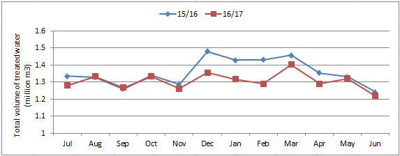
12 Water
demand followed a similar pattern to last year, although demand reduced in the
December to February period due to a milder summer. Demand returned to
traditional levels during March, and followed usual seasonal trends for the rest
of the year. Overall water demand was lower for the 2016/17 year at a total
amount of 15,663,051m3, compared to a total amount of 16,261,845 m3
in the 2015/16 year.
13 Percentage
response times met ≤24hours
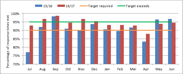
|
Quarter Ending 30 June
2017
|
Response Times Met
|
|
Total
|
588/638
|
92.16%
|
|
Water
|
478/517
|
92.46%
|
|
Wastewater
|
98/108
|
90.74%
|
|
Stormwater
|
12/13
|
92.31%
|
|
Year Ending 30 June 2017
|
Response Times Met
|
|
Total
|
2670/2844
|
93.88%
|
|
Water
|
2167/2319
|
93.45%
|
|
Wastewater
|
441/459
|
96.08%
|
|
Stormwater
|
62/66
|
93.94%
|
14 For
the month of June, the target of meeting 90% of priority work orders within 24
hours was met.
15 For
the 2016/17 year 93.9% of priority work orders had a response time of less than
24 hours, meeting the required target. This is an improvement over the 2015/16
year where only 89.5% of priority work orders had a response time of less than
24 hours.
16 Number
of customer complaints for drinking water
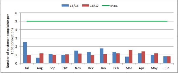
|
Customer Complaint Concerning
|
Raw number of Complaints (Q4)
|
Raw number of complaints (2016/17)
|
|
Continuity of supply
|
25
|
351
|
|
Drinking water clarity
|
5
|
93
|
|
Drinking water taste
|
0
|
0
|
|
Drinking water odour
|
0
|
6
|
|
Drinking water pressure or flow
|
5
|
124
|
|
Local authorities response to water
issues
|
1
|
17
|
17 The
majority of drinking water complaints from customers are regarding continuity
of supply or pressure/flow issues, which usually occur due to an unplanned
shutdowns from watermain breaks.
18 No
taste complaints were received for the 2016/17 year and the total number of
complaints has reduced year on year.
19 Number
of wet weather wastewater overflows
20 The
rainfall across this quarter was not significant. The Musselburgh rain gauge
recorded a cumulative total of 136.4mm, 40.8mm and 46.2mm of rainfall in April,
May and June respectively.
21 During
this period one rainfall ‘event’ was recorded. The event occurred
on the 12th April 2017 as 58.6mm of rain fell in the 24 hour period. This
equates to greater than a 1 in 2 year rainfall event which is classed as 54mm
within 24 hours.
22 During
this quarter there were a total of 14 recorded overflow spills (all of which
were wet weather overflows).
23 Kaikorai
Valley overflow spilt the most frequently, 5 times in total. The most
significant was across 4 days in April - 12th, 13th, 14th, 15th with a total
volume spilt of 2,189m3. This related to the rainfall event that was
greater than a 1 in 2 year event. The other overflow spills were all less than
7m3.
24 The
April rainfall event caused most of the monitored overflow sites to
spill. Sawyers Bay pump station spilt volumes totals of 45m3, 251m3 and
90m3 on the 12th, 13th and 14th April respectively. The Lindsey Creek overflow
spilt a total volume of 4,575m3 during 12th, 13th, 14th and 15th April 2017.
Marne Street pump station spilt volumes of 449m3 and 777m3 on the 12th and 14th
April 2017 respectively. The Nairn Street duck pond overflow spilt a volume of
347m3 during 12th, 13th, 14th and 15th April 2017. Union Street overflow did
not spill during this rainfall event.
25 Sawyers
Bay pump station overflow spilt a fourth time which related to a planned power
outage at a downstream pump station. The planned power outage from Delta
affected Burkes pump stations number 2 and 3. Planned mitigation included a
vacuum tanker at Burkes pump stations number 2 and 3 taking wastewater to Maia
pump station during the outage.
26 However,
wastewater volumes were slightly higher than anticipated and the small overflow
at Sawyers Bay still occurred; therefore 2 vacuum tankers will be used for any
future planned power outages. NZ Clams were notified of the incident so that they
could undertake sampling to confirm closure of 28 or 14 days.
27 Lindsey
Creek overflow spilt a second time, a small volume of 1m3 on the 12th June
2017.
28 Staff
are planning an overflow pilot study at Lindsay Creek to trial a live web
portal indicating if the site is overflowing or not.
29 The
2016/17 year saw a total of 48 wet weather and 3 dry weather overflows. While
the 2015/16 year saw a total of 31 wet weather and 2 dry weather overflows.
Value
& Efficiency
30 Number
of watermain breaks (12month rolling average)
31 The
on-going decrease in the number of watermain breaks suggests the positive
effect of the watermain renewal programme. Also, low numbers of bursts last
winter (due to few frosts) and during the summer (due to the absence of drought/ground
shrinkage) has assisted.
32 Average
duration of unplanned watermain shutdowns in minutes
33 The
recording of water shutdowns has been problematic for on-site staff, with many
shutdowns not being recorded in the work management system. A work-around was
implemented in late November 2016, which has led to a greater percentage of
shutdowns being recorded. Changes to the contractor’s IT system are being
planned to enable on-site staff to record shutdowns.
34 Since
the improvement in the recording of shutdown data it can be seen that unplanned
shutdowns times on average are meeting (or close to) the target of under 90
minutes in duration.
35 The overall average
duration for unplanned water shutdowns for the 2106/17 year was 85 minutes.
This is meeting the target of 90minutes or less.
36 Number
of foul sewer blockages (12month rolling average)
37 The
number of foul sewer blockages for the 2016/17 year although less than the
target was still similar to the prior year. Staff are investigating
problem areas to identity potential solutions.
38 Percentage
wastewater discharge consent compliance
39 The
wastewater discharge consent compliance for the 4th quarter of the
2016/17 year was 95.84%.
40 The
total compliance for the 2016/17 year was 95.45%, down from 2015/16 year
performance of 96.12%.
41 Analysing
the performance revealed:
a) Seacliff
wastewater treatment plant consistently breached the Nitrogen consent limit but
there have been no reports of negative environmental impact.
b) Tahuna
wastewater treatment plant consistently breached BOD, TSS, Oils & Grease,
Faecal Coliforms & Enteroccoci. Silver and Aluminium had some
breaches early in the quarter but later results were under the limit.
c) A
few samples were missed at Waikouaiti following damage to the bore during tree
harvesting. A new bore was installed during the week of 24 July.
42 Although
consent limits have been breached on occasion, testing by NIWA completed in May
and June 2017, has identified that the performance of the Tahuna and Green
Island plants is not negatively impacting the marine environment.
43 Consent
conditions, particularly for Tahuna Wastewater Treatment Plant, will be
reviewed in the 2017/18 year with the aim of altering some conditions to
reflect impact on the environment and therefore improving wastewater discharge
compliance.
44 Percentage
planned maintenance completed
45 In
June, all planned maintenance work orders were completed in the allocated
timeframe (280 work orders).
46 Over
the 2016/17 year, most of the network planned maintenance was able to be
completed within the given timeframe (98.99%), apart from Christmas when
staffing levels were lower, and again in April when a number of planned work
orders were cancelled in favour of preparation for an extreme weather warning.
47 Over
the 2016/17 year, the majority of plant planned maintenance was able to be
completed within the given timeframe (79.86%). A resource review has been
completed to improve performance in this area.
Major
initiatives
48 Kaikorai Valley
Phase 3 – The scope of works is under review with the aim of work
beginning in early 2018. A portion of the works in School Street to
address localised flooding issues, will be carried out in late 2017.
49 Kaikorai Valley
Phase 4 – This project is in the planning stage and involves work in
180 private properties. An extensive stakeholder engagement and
communication strategy for this project is being developed.
50 Security of
Supply Strategy – The construction works for the Ross Creek Dam
refurbishment project are underway. A tender for the detailed design of a
pump station and pipe to convey water from Ross Creek to Mt Grand will be
advertised in September 2017.
51 Waikouaiti
renewal – Replacement of the cast iron watermains and a small foul
sewer section is underway by Whitestone contracting and expected completion is
early 2018.
52 Alva St &
Wren Lane – The physical works to renew wastewater and water
pipelines in this area are complete.
53 Emerson St –
The stormwater rehabilitation work in this street is complete.
54 Every/Jeffrey/Highcliff
Renewals – The phase 1 water and wastewater pipe renewals are now
complete. Additional work for phase 2 has been awarded to Fulton Hogan,
starting in September 2017 and due for completion in early 2018.
55 Switchboard
Upgrades – This project upgrades a number of switchboards to ensure
health and safety compliance, for a total project value of $2.8m. The first
stage (Mosgiel WWTP) is complete and Green Island WWTP (package 2) was awarded
to Pace Electrical and is underway. The third stage of works at Tahuna WWTP is
progressing.
56 South Dunedin – Stormwater
management planning continues, with a Rising Groundwater study completed by
Golders/Deltares that will support further work on option feasibility.
Staff will report to the Committee on progress later this year.
57 Plant
Asset Data Information – A plant asset condition data assessment is
underway. This will project will assist in confirming condition and remaining
life of assets and inform monitoring and renewal programmes.
58 Top 5 Capital
Projects summary currently under execution:
|
Name
|
Construction
contract Budget
|
Construction
contract actual to date*
|
|
Ross Creek Reservoir
|
$6,608k
|
$1,824k
|
|
Every/Jeffrey/Highcliff/Sunbury St
renewals
|
$2,859k
|
$1,776k
|
|
Switchboard Upgrades
|
$2,200k
|
$959k
|
|
Waikouaiti Renewals
|
$1,650k
|
$56k
|
|
Kaikorai Valley 3
|
$7,200k
|
$347k
|
*Figures are as at 14th
July 2017
OPTIONS
59 As this is an update
report, there are no options.
NEXT STEPS
60 Areas of focus for
the next quarter will be:
a) Finalising
works for the School Street section of Kaikorai Valley Phase 3
b) Tendering
stormwater works at Sawyers Bay Pony Club and Woodland Avenue
c) Tendering the
design of the Ross Creek to Mt Grand Pump Station and Pipeline
d) Completing an
event and infrastructure performance analysis of the July 2017 rainfall.
Signatories
|
Author:
|
Hayley Knight - Business Performance Coordinator/PA
Chris Henderson - Acting Group Manager Water and Waste
|
|
Authoriser:
|
Ruth Stokes - General Manager Infrastructure and
Networks
|
Attachments
There are no attachments for
this report.
|
SUMMARY OF CONSIDERATIONS
|
|
Fit with purpose
of Local Government
This decision relates to providing local infrastructure
that is considered good-quality and cost-effective.
|
|
Fit with strategic
framework
|
|
Contributes
|
Detracts
|
Not applicable
|
|
Social Wellbeing Strategy
|
☒
|
☐
|
☐
|
|
Economic Development Strategy
|
☐
|
☐
|
☒
|
|
Environment Strategy
|
☒
|
☒
|
☐
|
|
Arts and Culture Strategy
|
☐
|
☐
|
☒
|
|
3 Waters Strategy
|
☒
|
☐
|
☒
|
|
Spatial Plan
|
☐
|
☐
|
☒
|
|
Integrated Transport Strategy
|
☐
|
☐
|
☒
|
|
Parks and Recreation Strategy
|
☐
|
☐
|
☐
|
|
Other strategic projects/policies/plans
|
☒
|
☐
|
☐
|
The Three waters activities support the outcomes of a
number of strategies.
|
|
Māori Impact
Statement
There are no known impacts for tangata whenua.
|
|
Sustainability
The 3 Waters activity contributes positively to the
interests of the community by ensuring the provision of safe drinking water,
and the safe and sustainable disposal of wastewater and stormwater.
|
|
LTP/Annual Plan /
Financial Strategy
The 3 Waters Activities are included in the Long Term
Plan.
|
|
Financial
considerations
The updates reported are within existing operating and
capital budgets.
|
|
Significance
This decision is considered of low significance under the
Significance and Engagement Policy.
|
|
Engagement -
external
As an update report no external engagement has been
undertaken.
|
|
Engagement –
internal
As an update report no internal engagement has been
undertaken.
|
|
Risks: Legal /
Health and Safety / Conflict of Interest etc.
There are no identified risks.
|
|
Community Boards
Not applicable.
|
|
Infrastructure Services and
Networks Committee
14 August 2017
|
|
Solid Waste Activity Report
for the Quarter Ending 30 June 2017
Department: Water and Waste
EXECUTIVE SUMMARY
1 This
report updates the Committee on Solid Waste operations, maintenance and capital
works, including contracted out services.
2 Highlights
for the quarter include:
a) Contracts have
been signed with GHD Limited for Landfill Monitoring and Reporting and with
Waste Management Limited for Green Island Landfill and Transfer Station. An
interim contract, 3 month period, has been put in place with Waste Management
for Rural Transfer Stations and Rural Skip Day services to allow sufficient
time to conclude negotiations on a 9 month plus 1 year contract.
b) Planning for a
kerbside three month programme of checking yellow-lidded recycling bins for
contamination (non-recyclables) is being finalised. The aim of this programme
will be to further educate our community about good recycling practice and to
reduce contamination rates (non-recyclables being deposited in recycling bins).
|
RECOMMENDATIONS
That the Committee:
a) Notes the
Solid Waste Activity Report for the Quarter ended 30 June 2017.
|
BACKGROUND
3 The Solid
Waste activity provides for effective collection, resource recovery and
residual disposal in a way that protects public health, and minimises impact on
the environment.
4 The Solid
Waste activity includes:
a) Kerbside
collection of waste and recycling for most urban and city residents and small
businesses.
b) Disposal
Facilities (landfill and transfer station) for waste and Resource Recovery
Centre (recycling and reuse store) are provided for at Councils Green Island
site. The Waikouaiti site has both a transfer station for waste disposal and
recycling facilities. Middlemarch has a transfer station and a hosted community
recycling drop off centre. Waste collected at the community transfer stations
is then transferred to Green Island Landfill for landfill disposal. All recycling
is sent to the Material Recovery Centre for sorting and transportation to
recycling markets.
c) Public place
recycling infrastructure and servicing is provided on the streets in the CBD
and several satellite locations in the district.
d) Monitoring the
state of the Council’s open and four closed landfills in accordance with
conditions of consents.
e) Education
programmes promoting “rethinking, reducing, reusing and recycling”,
cleaner production and sustainable business practice.
DISCUSSION
Management
of Solid Waste services
5 Kerbside
collection services (refuse and recyclables) are carried out by Enviroway Ltd
in urban Dunedin. Kerbside collection services in Middlemarch are carried out
by a sub-contractor to Enviroway Ltd.
6 The
management and operation of the Green Island landfill is carried out by Waste
Management Ltd. The transfer stations and resource recovery centres at
Waikouaiti and Middlemarch are managed by a sub-contractor to Waste Management
Ltd.
7 Environmental
monitoring and reporting of Councils active landfill at Green Island and five
closed landfills; Waikouaiti, Middlemarch, Forrester Park, North Taieri and
Sawyers Bay is conducted by GHD Ltd.
8 The
collection of illegally dumped rubbish, empting of street litter bins,
including recycling bins and Moray Place recycling facility, refuse (DCC bags)
and recycling (cardboard) collection services in the CBD, are contracted to
McCallum Street Sweeping Services Ltd.
Non-financial
performance
Service
9 Number of
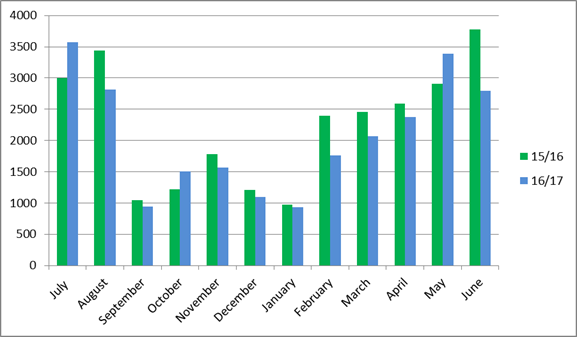
complaints regarding missed collections after 4pm
10 Although there are
some large variations month by month, the overall total number of complaints
received for missed collections is down by 33 for the whole 2016/17 year
compared to the 2015/16 year. This improvement could be due to improved
communications regarding when collections may be missed due to adverse weather
conditions. Or due to the decrease in the number of adverse weather conditions
due to a milder winter period.
Value and Efficiency
11 Total waste
collected and diverted.
12 Although the figures
for June are not yet available it appears over the whole year the overall
diverted material tonnage is about the same as the previous year. The higher
volume of diverted material in March 2017 could be due to increased collections
in the student quarter. The main changes in types of material are an increase
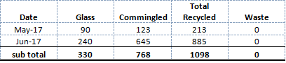
in Glass, Cardboard, Plastic and Cans with a decrease in Paper.
Major
initiatives
13 Waste Services
Contracts – Three Waste Contracts: Landfill Environmental Monitoring
and Reporting, Rural Transfer Stations and Rural Skip Day Services and Green
Island Landfill and Transfer Station became operational on 1 July 2017. The
handover has been smooth with minimal disruption to services recorded.
14 Staff are assisting
the new contractor, Waste Management, with site and service familiarisation
until they settle into a business as usual state. This has included activity
providing feedback on developing site Health and Safety, Operations and
Emergency Plans. An interim contract has been put in place with Waste
Management for the Rural Transfer Stations and Rural Skip Day Services as more
time was needed to conclude negotiations to the satisfaction of both parties
recognising that the timeframe was tight.
15 City Recycling Facilities
– Recyclables are being collected from the Moray Place Recycling
Facility. The material being collection has been clean and free from
contamination.
Total kilograms recycled at the Moray Place Recycling
Facility
There has been one reported incident of illegal dumping at
the site however, this turned out to be a business owner moving rubbish bags
from the bottom of View Street to the recycling centre for collection. Staff
have spoken to the business owner.
Non-compliant bags are still being deposited at the bottom
of View Street by some residents in the area. Staff are planning a series of
visits to this location over a two week period to record time bags appear and
number of non-compliant incidence. This is to prepare for a survey of the community.
Staff will visit the area over a couple of evenings when it
gets lighter, to speak about why it is important to use DCC rubbish bags,
inform about collection times, give out bags for carrying recyclables to the
facility and to obtain customer feedback on available services in the area.
16 City Cardboard
Collection Kerbside – There are 25 safe locations for the kerbside
collection of cardboard in the city and South Dunedin Shopping Precinct. The
kerbside collection of cardboard has been removed from the busiest parts of
George, Princes, Great King, Lower Stuart and King Edward Streets for both
safety and city amenity reasons. Most businesses are using the collection
points provided, there are a small number of businesses that aren’t and
staff are following up with the business proprietors directly if known.
17 City Cardboard
Collection Back of House – There are 24 back of house locations for
cardboard collection services. This is a shared service model whereby business
clusters agree to collaborate and DCC provides a cardboard collection bin and
collection services to the host business. The agreement is supported by a
Memorandum of Understanding and is working well for the most part. A couple of
areas needed more capacity and additional bins were supplied in these
locations.
18 Kerbside
Recycling Bin Inspections - Residential kerbside recycling bin inspections
began in early July. A 12 week trial aims to further reduce recycling bin
contamination rates and minimise hazardous materials being deposited in recycling
bins.
19 New bin tags,
letters and communications are being developed which will identify issues and
support good recycling practices i.e.; there will be an opportunity for
residents with some recycling bin contamination to correct their recycling
habits, residents who have been identified as good recyclers will receive a
thank you from DCC and recycling bins that have clearly been identified as
being used as rubbish bins or contain hazardous materials e.g. medical waste or
soiled nappies will not be emptied. Recycling bins that continue being
contaminated may be removed.
20 E-waste Recycling
– Staff have identified improvements to promote and engage the community
in greater e-waste recycling. Negotiations with Cargill Enterprises are
underway to receive all e-waste from DCC drop off sites (currently the Rummage
Reuse Store). This will include TV’s which have previously gone to
another recycler in Christchurch and the introduction of a battery recycling
service.
21 Organics
Reduction – A joint DCC and FoodShare CBD food rescue programme was
launched at the end of June. Participating food service businesses will display
a window sticker showing their support for food rescue which is co-branded
FoodShare supported by DCC.
22 Waikouaiti Closed
Landfill and Transfer Station - A working group has been established and
met for the first time in May to progress service and site improvements at
Waikouaiti Transfer Station and Resource Recovery Centre. The remaining 2016/17
Capital budget has been carried over to support stage 1 improvements to site
i.e. new booth, barriers and access to hygiene facilities. Further capital
budget has been requested for the 2017/18 year for stage 2 improvements that
aim to increase resource recovery at the site.
23 The final closure of
Waikouaiti Landfill will take place towards the end of the calendar year as
warmer weather is needed for major earthworks. Capping material for this
project is available from another council project and this is being delivered
to the site and stockpiled.
Capital
projects
|
Name
|
Budget Full Year
|
Actual YTD
|
|
City Recycling
Facilities
|
$0.00
|
$117,439.00
|
|
Waikouaiti Landfill
Decommissioning
|
$100,000.00
|
$6,377.00
|
|
Waikouaiti Transfer
Station
|
$100,000.00
|
$1,005.00
|
|
Recycling Wheelie Bins
|
$0.00
|
$71,934.00
|
|
Green Island
Improvements to Final Cap
|
$183,500.00
|
$0.00
|
|
Compost for Final Cap
|
$32,600.00
|
$0.00
|
|
Green Island Landfill
Gas Collection
|
$36,909.00
|
$342,891.00
|
|
Litter Bin Renewals
|
$0.00
|
$56,559.00
|
|
Green Island Landfill
Renewals
|
$325,600.00
|
$70,905.00
|
24 Capital spend on
City Recycling has been offset by reduced expenditure elsewhere in the budget.
It includes all design, consultancy and additional materials i.e. collection
bins and cardboard collection plaques for kerbside collection points. The Vogel
Street Facility will be installed in late August/early September.
25 With the bulk stock
of kerbside yellow-lidded wheelie bins now used there has been additional costs
associated with the purchase of additional wheelie bins. These are to replace
lost or damaged bins.
26 There will be an
anticipated increase in capital spending in the coming financial year with the
appointment of the Landfill Engineer within the Solid Waste team. Priorities
are being set and improvement projects scoped.
OPTIONS
27 As this is an update
report, there are no options.
NEXT STEPS
28 Areas of focus for
the next quarter will be:
· Launching
the kerbside yellow-bin bin checking recycling programme.
· Partnering
with Cargill Enterprises to promoting e-waste recycling services and support
for social enterprise in Dunedin. A launch date will be notified in the once
negotiations have been concluded.
· Working
with the University to model a ‘This is my Neighbourhood’ social
awareness campaign. This follows on from concerns raised by residents living in
the campus area about the level of broken glass, and litter on streets and
pavements. The aim of this campaign is to make students more aware of other
people that live, work, attend school and early childhood centres in the area.
· Scoping
priority capital improvements for further plan development.
· Investigating
options for increasing organic waste diversion; including food, garden,
disposable nappies and compostable packaging. This review will determine what
available services and facilities, cost and applicability to Dunedin. This
information will inform a wider review of kerbside collection services.
Signatories
|
Author:
|
Catherine Irvine - Solid Waste Manager
Hayley Knight - Business Performance Coordinator/PA
|
|
Authoriser:
|
Chris Henderson - Acting Group Manager Water and Waste
Ruth Stokes - General Manager Infrastructure and
Networks
|
Attachments
|
There are no attachments
for this report. SUMMARY OF CONSIDERATIONS
|
|
Fit with purpose
of Local Government
This decision relates to providing local infrastructure
that is considered good-quality and cost-effective.
|
|
Fit with strategic
framework
|
|
Contributes
|
Detracts
|
Not applicable
|
|
Social Wellbeing Strategy
|
☒
|
☐
|
☐
|
|
Economic Development Strategy
|
☐
|
☐
|
☒
|
|
Environment Strategy
|
☒
|
☒
|
☐
|
|
Arts and Culture Strategy
|
☐
|
☐
|
☒
|
|
3 Waters Strategy
|
☐
|
☐
|
☒
|
|
Spatial Plan
|
☐
|
☐
|
☒
|
|
Integrated Transport Strategy
|
☐
|
☐
|
☒
|
|
Parks and Recreation Strategy
|
☐
|
☐
|
☒
|
|
Other strategic projects/policies/plans
|
☒
|
☐
|
☐
|
The solid waste activity supports the outcomes of a number
of strategies.
|
|
Māori Impact
Statement
There are no known impacts for tangata whenua.
|
|
Sustainability
The solid waste activity
contributes positively to the environmental interests of the community
through refuse and recycling collection at the kerbside and public places,
educating and promoting environmentally sustainable behaviour and managing
landfill and transfer station facilities.
|
|
LTP/Annual Plan /
Financial Strategy /Infrastructure Strategy
The solid waste activity is included in the Long Term
Plan.
|
|
Financial considerations
The updates reported are within existing operating and
capital budgets.
|
|
Significance
This decision is considered of low significance under the
Significance and Engagement Policy.
|
|
Engagement –
external
As an update report no external engagement has been
undertaken.
|
|
Engagement -
internal
As an update report no internal engagement has been
undertaken.
|
|
Risks: Legal /
Health and Safety etc.
There are no identified risks.
|
|
Conflict of
Interest
There are no identified conflicts of interest.
|
|
Community Boards
Not applicable.
|
|
Infrastructure Services and
Networks Committee
14 August 2017
|
|
Parks and Recreation Activity Report for Year
Ending 30 June 2017
Department: Parks and Recreation
EXECUTIVE SUMMARY
1 This
report updates the Committee on Parks & Recreation operations, maintenance
and capital works, including contracted out services.
2 Highlights
for the quarter include:
· Awarding
of Ecological and tracks maintenance contract to Upfront Environmental.
· The
Department of Conservation committing to the shared Volunteer Coordinator
resource for a further 12 months.
|
RECOMMENDATIONS
That the Committee:
a) Notes the
Parks and Recreation Activity Report for the Quarter ending 30 June 2017.
|
BACKGROUND
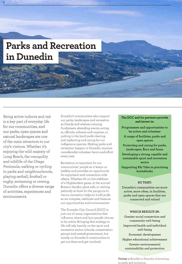
3 The Parks
& Recreation activity provides public access to pools, urban green space,
sports fields and facilities, recreation and leisure opportunities and a
botanic garden of international significance.
DISCUSSION
Management of Parks
& Recreation Services
4 Council
manages Moana Pool, Mosgiel Community Pool, Port Chalmers Community Pool, and
St Clair Hot Saltwater Pool. The pools support casual swimming,
professional swimming coaching, and learn-to-swim programmes.
5 Moana
Pool is open year round, with additional services including: crèche,
hydroslides, gym, physiotherapy, massage, and a retail shop. Mosgiel
Community Pool is open seven months of the year and both Port Chalmers
Community Pool and St Clair Hot Saltwater Pool are open for six months of the
year. In addition, the Council provides grants for the community pool at
Middlemarch, Moana Gow Pool and a number of school pools.
6 The
Botanic Garden has 19 themed-garden collections and an aviary and is graded as
a Garden of International Significance by the NZ Gardens Trust.
7 Council
manages a wide range of open spaces providing parks and recreation facilities,
for both organised and casual use including playgrounds, sports fields,
cemeteries, parks and walkways. The maintenance of these spaces is
contracted out, with Council staff overseeing operations including formal and
informal lease/use arrangements, and the development and implementation of
policies and plans relating to parks and recreation.
Non-financial
performance
Value and
Efficiency
Sports Facilities
Bookings
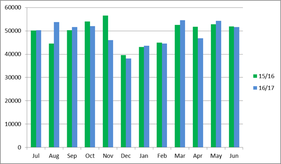
8 Bookings
maintained a consistent trend comparative with the previous financial year,
with an increase in bookings in May attributed to University semester timing
and sports code scheduling. The decrease in June reflects poor weather and the University
break.
Visitor
Numbers at Moana Pool
9 Visitor
numbers at Moana Pool were consistent with the previous year. Staff have
estimated the missing visitor numbers for November (reported previously)
through analysing till receipts and taking a monthly average of pool entries
across the year.
Total Burials at all
Cemeteries
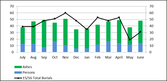
10 Cremations have
continued the expected trend with the opening of the Hope and Sons Ltd
facility. Options for future service delivery are being evaluated.
Volunteer Contribution
|
Month
|
Number of Volunteers
|
No. of Hours
|
Cost equivalent
|
|
November 16
|
18
|
45
|
$1,265.40
|
|
December 16
|
15
|
88
|
$2,474.56
|
|
January 17
|
34
|
160
|
$4,494.20
|
|
February 17
|
75
|
142
|
$3993.04
|
|
March 17
|
30
|
281
|
$7901.72
|
|
April 17
|
82
|
441.5
|
$12,414.98
|
|
May 17
|
68
|
315
|
$8,857.8
|
|
June 17
|
47
|
272
|
$7,648.64
|
11 The measured
contribution of volunteers dedicating time to the Dunedin’s recreation
space is steadily rising. The increase is in part a function of active
engagement and activation of volunteers through the joint Department of
Conservation (DOC) and DCC Volunteer Co-ordinator.
12 Other established
volunteer groups such as the Green Hut Track Group are beginning to formally
report on their activities also. Volunteer activities included habitat
restoration and beautification projects.
Major
Initiatives
New Contracts
13 During the year to
date a significant focus has been on the introduction of new contracts. The
Ecological and Track Maintenance contracts were awarded at the end of June. The
Pest Control contracts will be awarded in the first quarter of 17/18 following
the evaluation of tenders.
Aramoana Wharf Removal
14 Staff met with DOC
officers in May to discuss the draft concession. Design, access, mitigation of
environmental effects and location were the areas identified as requiring
further work before a final concession will be lodged. Staff are working with
the Trust to assist in finalising the application before submission.
15 Engagement with key
stakeholders groups is on-going.
Logan Park Redevelopment
Plan
16 Staff have engaged
Boffa Miskell as specialist recreation planning consultants to deliver a
concept plan for the Logan Park Redevelopment. Engagement and input from a
range of stakeholders has begun and a staged and costed detailed design will be
complete by October.
Predator Free Dunedin Memorandum
of Understanding
17 Staff have been
working with conservation groups in the greater Dunedin community to support
the establishment of “Predator Free Dunedin”. Predator Free Dunedin
is working under the Government led Predator Free 2050 programme to rid Dunedin
of damaging introduced species.
18 The Dunedin City
Council is part of a Memorandum of Understanding recognising the collaborative
approach to developing a city wide Predator Free Dunedin Management Plan that
aligns with the national Predator Free 2050 target.
19 Staff are working
with Predator Free Dunedin to create a scoping report, examining how pest
operations could be carried out. The scoping report will tie in with the pest
control plan.
Town Belt Education
Initiative
20 Funding was secured
for the implementation of the Dunedin Town Belt Education Initiative for
2017/18. The Initiative is a collaborative education model, designed to
provide schools with the tools and resources to use the Town Belt as a context
for education.
21 A Strategic
Leadership Group (SLG) will provide governance for the Initiative and is
composed of: The Department of Conservation (DOC) Dunedin City Council (DCC),
Te Rūnanga o Ōtākou, Kāti Huirapa Runaka ki Puketeraki, Te
Rūnanga o Ngāi Tahu, Dunedin Amenities Society, representatives
from role model schools, University of Otago, Toitu, Chamber of Commerce and
Predator Free Dunedin.
22 The SLG will employ
an Education Coordinator who will work with the SLG, teachers, students and
community to deliver the initiative on the ground. 10 schools ranging
from early childhood centres to high school have agreed to be a part of the
pilot. The aim is for teachers to use the Town Belt as an external
classroom. The Initiative is designed to be scalable so that more
schools and other areas can be involved.
Volunteer Projects
23 The Department of
Conservation has confirmed its commitment to the shared Volunteer Projects
Facilitator with funding continuing for 2017/18 financial year.
24 The trail crew
volunteer work programme, which supports community groups with track works has
expanded during the quarter, and now has 150 members. In May, the work was
expanded to include DCC tracks in addition to DOC tracks.
25 Development of a
joint salt marsh restoration project at Purakaunui estuary is underway with
DOC, DCC, student groups, and Purakaunui iwi. The project has received
biodiversity funding.
Magical Playground
26 The Magical
Playground has had 467 visits with a total of 187 game sessions since
December. GeoAR Games has released a new version of the app and there are
now three games to choose from: Augmentia, Prehistoria and AlienScape.
Challenges with the game have been device compatibility and weather, with
winter having a significant impact on user numbers.
27 The license will
finish in December and a decision to renew or change locations will be made
after consultation with the local community.
Capital Projects
|
Name
|
Budget
|
Actual (to date)
|
Status
|
|
Ocean Beach Remedial Works
|
$0 – approved
overspend
|
$659,000
|
Complete
|
|
Warrington Domain Toilet Upgrade
|
$50,000
|
$50,803
|
Complete
|
|
Botanic Garden - Glass House Demolition and Site
Reinstatement
|
$84,000
|
$60,452
|
Complete
|
|
Botanic Garden Duck Pond Pier
|
$42,000
|
$40,639
|
Complete
|
|
Baldwin Street Toilet
|
$100,000
|
$177,300
|
Complete
|
|
Mosgiel East Playground Development
|
$39,800
|
$44,425
|
Complete
|
Asset Renewals
|
Name
|
Budget
|
Actual (to date)
|
|
|
Cremator Refractory Refurbishment
|
$70,000
|
$71,000
|
Complete
|
|
Tahuna A&P Building Asbestos Removal and Re-roof
|
$55,000
|
$45,612
|
Complete
|
|
University 4 and 5 Field Refurbishment
|
$205,000
|
$417,055
|
Complete
|
|
Sims Building Refurbishment
|
$450,000
|
$189,093
|
Underway
|
|
Tahuna Park Pavillion and Grandstand Re-roof
|
$285,000
|
$152,343
|
Underway
|
|
Mosgiel Gym Roof Renewal
|
$116,000
|
$104,206
|
Complete
|
Ocean Beach
28 Staff have continued
to monitor the performance of the geotextile tubes at Ocean Beach. Since the
installation in July 2016, rocks have been cleared and additional sand placed
in front of the structures. A sand stockpile at Ocean Beach is available
if sand levels drop in front of the coastal protection structures during
storms.
Highland Park
29 The development of
Highland Park has been let, with work including contouring, fitness circuit,
playground, paths and planting.
Mosgiel Pool
30 The Taieri Community
Facilities Trust (the Trust) finished consultation on two sites in the Memorial
Gardens area at the end of February, with Council confirming preference for the
existing site in April 2017. The Trust has developed a fundraising committee to
drive fundraising efforts.
All Weather Sports Turf
31 Staff are working
with Football South to progress the design and build of the all-weather
artificial sports turf at Logan Park. This project will run parallel with
the Logan Park Redevelopment Plan.
Freedom Camping
32 Based on the
decision made by Council, staff have begun the Special Consultative Process to
review future options for freedom camping in the city. This process provides
the public with three options:
· Option
1 – proposed option – to limit freedom camping to certified
self-contained vehicles only
· Option
2 – Status quo with added measures
· Option
3 -Identifying and adding more locations for unrestricted freedom camping
33 Hearings will be
held at the end of August.
Moana Pool
34 Moana Pool staff
have revised the Pool Alone policy, with effect from 24 July. The changes
include increasing the age children need to be actively supervised from 8 years
old to 10, which results in an increase in the age a child can be left
unaccompanied at the pool to 10 years old. This change brings Moana in
line with other pools around the country and it is hoped that this will
decrease the amount of wet rescues.
Renewals
35 In February all
asbestos cladding was removed from the Tahuna Pavillion Building. Following the
removal of all asbestos the structure of the building was assessed and all
deficiencies were corrected and a new roof installed.
36 Work to remove
asbestos cladding from the Sims Building was substantially complete at the end
of March. There is a remaining portion of asbestos buried behind the building
in unstable ground and the remaining structure has been assessed as earthquake
prone. Staff are developing options for the site.
37 Work to establish
bulk storage bays for fertiliser and mulch at Tahuna began during the
quarterand is expected to be complete by mid-August 2017.
OPTIONS 38 As
this is an update report, there are no options.
NEXT STEPS
Areas of focus for the next quarter (1
July – 30 September) will be:
39 Completing the
freedom camping special consultative process and presenting the findings to the
Bylaw Subcommittee will be carried out in August.
40 Completing the
review of Fees and Charges for Parks and Recreation.
41 Presenting the Parks
and Recreation Strategy and two Action plans for approval at the Infrastructure
Services and Network Committee on 14 August 2017.
42 Establishing a base
level of service across the network of DCC tracks following a DOC audit.
43 Completing a safety
and condition audit of mountain biking tracks on Council land.
44 Working with Otago
Hockey Association and Kings High School on funding applications for the
artificial hockey turf.
Signatories
|
Author:
|
Mitchell Turner - Business Performance Coordinator
|
|
Authoriser:
|
Jendi Paterson - Recreation Planning and Facilities
Manager
Ruth Stokes - General Manager Infrastructure and
Networks
|
Attachments
There are no attachments for
this report.
|
SUMMARY OF CONSIDERATIONS
|
|
Fit with purpose
of Local Government
This decision relates to providing local services and
infrastructure that is considered good-quality and cost-effective.
|
|
Fit with strategic
framework
|
|
Contributes
|
Detracts
|
Not applicable
|
|
Social Wellbeing Strategy
|
☒
|
☐
|
☐
|
|
Economic Development Strategy
|
☒
|
☐
|
☐
|
|
Environment Strategy
|
☒
|
☐
|
☐
|
|
Arts and Culture Strategy
|
☒
|
☐
|
☐
|
|
3 Waters Strategy
|
☐
|
☐
|
☒
|
|
Spatial Plan
|
☐
|
☐
|
☒
|
|
Integrated Transport Strategy
|
☒
|
☐
|
☐
|
|
Parks and Recreation Strategy
|
☒
|
☐
|
☐
|
|
Other strategic projects/policies/plans
|
☒
|
☐
|
☐
|
The parks and recreation activity supports the outcomes of
a number of strategies.
|
|
Māori Impact
Statement
There are no known impacts for tangata whenua.
|
|
Sustainability
The Parks and Recreation activity
promotes the social and environmental interest of the community by providing
venues and support for sporting and leisure activity and provides garden and open green space that promotes the
environmental and social interests of the community.
|
|
LTP/Annual Plan /
Financial Strategy /Infrastructure Strategy
The parks and recreation activity is included in the long
term plan
|
|
Financial
considerations
The updates reported are within existing operating and
capital budgets
|
|
Significance
This decision is considered of low significance under the
Significance and Engagement Policy.
|
|
Engagement –
external
As an update report no external engagement has been
undertaken.
|
|
Engagement -
internal
As an update report no internal engagement has been
undertaken.
|
|
Risks: Legal /
Health and Safety etc.
There are no identified risks.
|
|
Conflict of
Interest
Not applicable
|
|
Community Boards
Not applicable
|
|
Infrastructure Services and
Networks Committee
14 August 2017
|
|
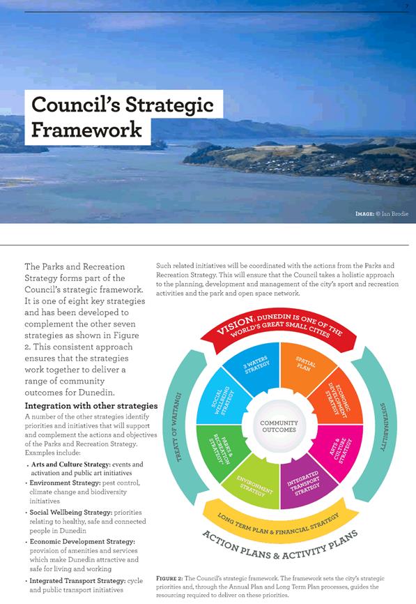
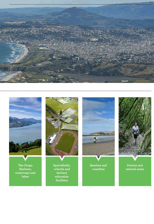
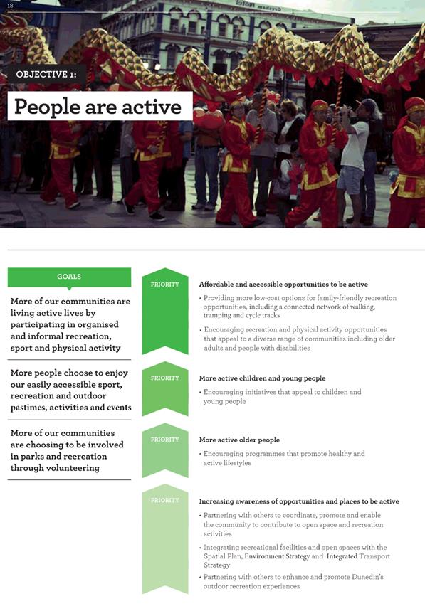
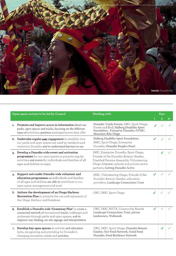
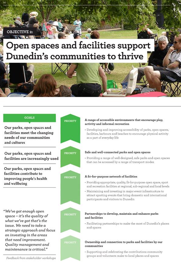
Parks and Recreation Strategy
Department: Parks and Recreation
EXECUTIVE SUMMARY
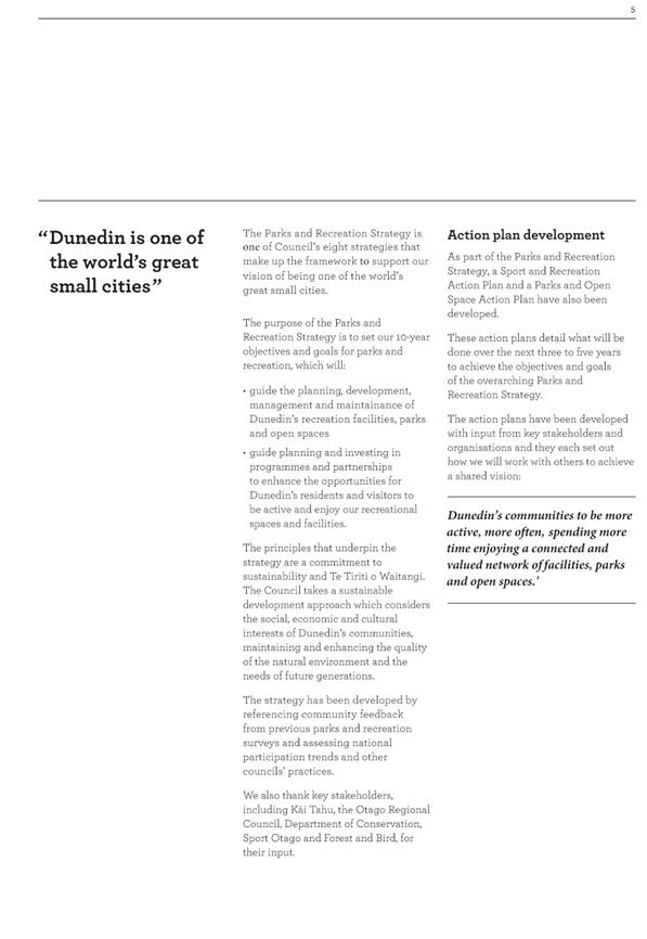
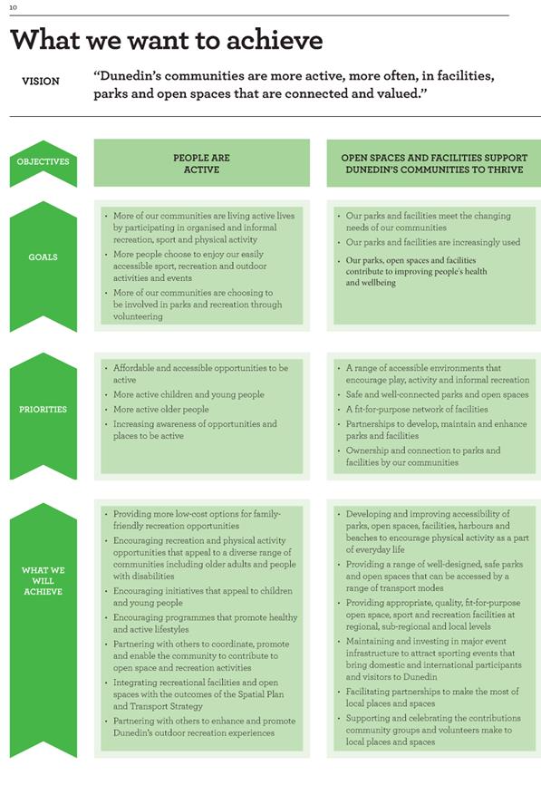
1 The
purpose of this report is to seek Infrastructure Services and Networks
Committee recommendation to Council that the Parks and Recreation Strategy
(2016-2026) including the Sport and Recreation Action Plan and the Open Space
Action Plan, is adopted at the Council meeting on 29 August 2017.
2 The
Parks and Recreation Strategy (the Strategy) is the final Strategy to be
developed as part of the Dunedin City Council’s Strategic framework. In
August 2016 the Community and Environment Committee endorsed the draft Strategy
for community consultation. The consultation period ended on 16 December 2016.
3 Feedback
received throughout the consultation period was generally in support of the
approach and direction outlined in the Strategy. Staff have subsequently
collated and summarised the feedback (Attachment B), which has resulted in
minor changes being made to the Strategy. Staff also continued to seek input
from key stakeholders on the development of the Strategy.
4 It
is recommended that the Infrastructure Services and Networks Committee approve
the amended Strategy (Attachment A) for Council adoption. Following adoption,
staff will proceed with finalising and publishing the Parks and Recreation
Strategy Document and developing the Parks and Recreation Strategy
implementation plan (the Plan).
5 The
Plan will be used to inform the development of the Parks and Recreation
Departments three year (2017-2020) work programme. Staff will regularly update
the Infrastructure Services and Networks Committee on the implementation of the
Strategy as part of the Parks and Recreation Groups Quarterly Report.
|
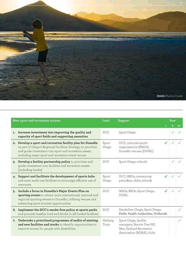
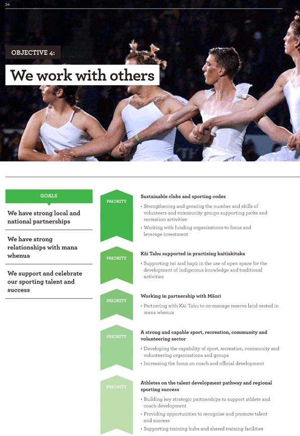
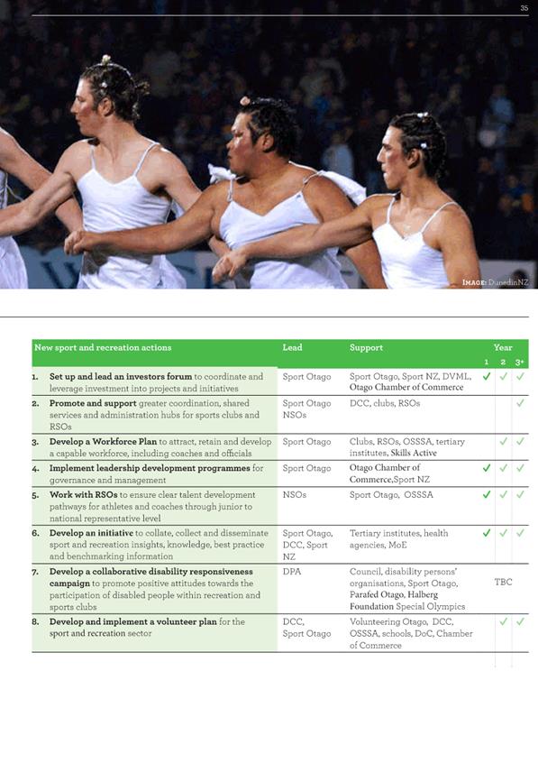
RECOMMENDATIONS
That the Committee:
a) Recommends
to Council that the Parks and Recreation Strategy (2016-2026), including
the Sport and Recreation Action Plan and Open Space Action Plan, is adopted
at the 29 August 2017 Council meeting.
|
BACKGROUND
6 Staff
reported a draft Strategy for endorsement to proceed with community
consultation to the Community and Environment Committee in August 2016. The
Strategy is the final component required to complete the Dunedin City
Council’s Strategic framework, which comprises eight key strategies.
7 Moved
(Cr Jinty MacTavish/Cr Kate Wilson): that the Committee:
a) Asks
staff to add reference to areas of overlap with, or that reference other
strategies e.g.
i) Cycling
initiatives from Integrated Transportation Strategy
ii) Pest
Control from Environment Strategy
iii) Events
in Arts and Culture Strategy
b) Approves
the draft Parks and Recreation Strategy (2016-2026), as amended, including the
Sport and Recreation Action Plan and Open Space Action Plan for community consultation,
subject to minor editorial amendments.
c) Notes
staff to report back following community consultation to Infrastructure
Services and Networks Committee in December 2016.
Motion carried (CE/2016/031) with Cr Vandervis voting against
8 Community
consultation on the draft strategy ran from November 14 2016 – December
2016. Between August 2016 and November 2016, staff addressed the request by the
Committee that the draft Strategy add reference to overlap with other
strategies, completed the graphic design (including infographics, logos and
images) of the document and published in a format suitable for consultation. A
consultation summary pamphlet was also produced.
9 Consultation
methods included:
a) distribution
of hard copies, posters and feedback forms available at Council facilities and
to key stakeholder organisations including Department of Conservation, Sport
Otago, Otago Regional Infrastructure Services and Networks Committee, Sport New
Zealand and Forest and Bird.
b) a
series of ‘pop up events’ at Council facilities, including
libraries and local pools.
c) emails
and PDF copies of the document to community networks and stakeholders.
d) promotion
of the strategy and the opportunity to provide feedback both online and in
print, including the Otago Daily Times, Facebook and the Dunedin City Council
website.
e) a
survey of The Dunedin People’s Panel
10 Over
100 submissions from members of the public and stakeholder organisations were
received. Stakeholders included the Otago Regional Council, Sport Otago,
Department of Conservation, Volunteering Otago, Kāi Tahu, Forest and Bird,
Sport New Zealand, Otago Regional Infrastructure Services and Networks
Committee, NZTA, Halberg Disability Sport Foundation and Enterprise Dunedin.
11 Council
also received 187 responses via the People’s panel.
DISCUSSION
12 Following
the end of the consultation period, staff collated and summarised the feedback
received. The feedback was generally in support of the Strategy, with the
majority of comments from both the wider community and stakeholders supporting
the vision, goals, priorities and actions of the Strategy.
13 A
number of comments commended the Council on the development of a holistic,
comprehensive and clearly written Strategy. There was strong support for the theme
of improving accessibility to parks and open spaces throughout the Strategy and
for the Strategy’s efforts to balance recreation with protection of flora
and fauna.
14 Feedback
that suggested additions/amendments to the strategy, focused primarily on the
actions within the Parks and Open Space Action Plan and the Sport and
Recreation Action Plan.
15 There
were also a number of requests from organisations, over and above the
stakeholders already involved, to be actively engaged in the ongoing implementation
of the Strategy.
16 Staff
collated and reviewed all feedback and identified seven key themes which have
been given more emphasis throughout the strategy:
a) being
active also includes leisure activities and pastimes, not only physical activity
b) the
value of a connected network of parks, open spaces, tracks and walkways to the
community
c) the
contribution of parks and recreation to the tourism industry
d) the
benefit of parks, recreation and activity to health and wellbeing
e) improving
Dunedin’s playgrounds and play spaces, including creating new destination
playgrounds and natural play areas
f) the
value of neighbourhood facilities, activities and recreation to the local
community
g) broaden
the people and organisations Council will work with to achieve the actions in
the action plans
17 Six
submitters considered that the Strategy goes beyond people being more active,
more often and that the Vision statement should be amended to reflect this. A
broader definition of active was also a theme throughout the feedback relating
to the Action Plans.
18 It
is therefore recommended that the Parks and Recreation Vision statement be
amended to ‘‘Dunedin’s communities are more active, more
often, spending more time enjoying a connected and valued network of
facilities, parks and open spaces’’
19 The
other proposed changes to the document relate primarily to the actions within
the action plans. A summary of feedback received and the proposed changes is
attached (Attachment B).
Monitoring and Review of the Action Plans
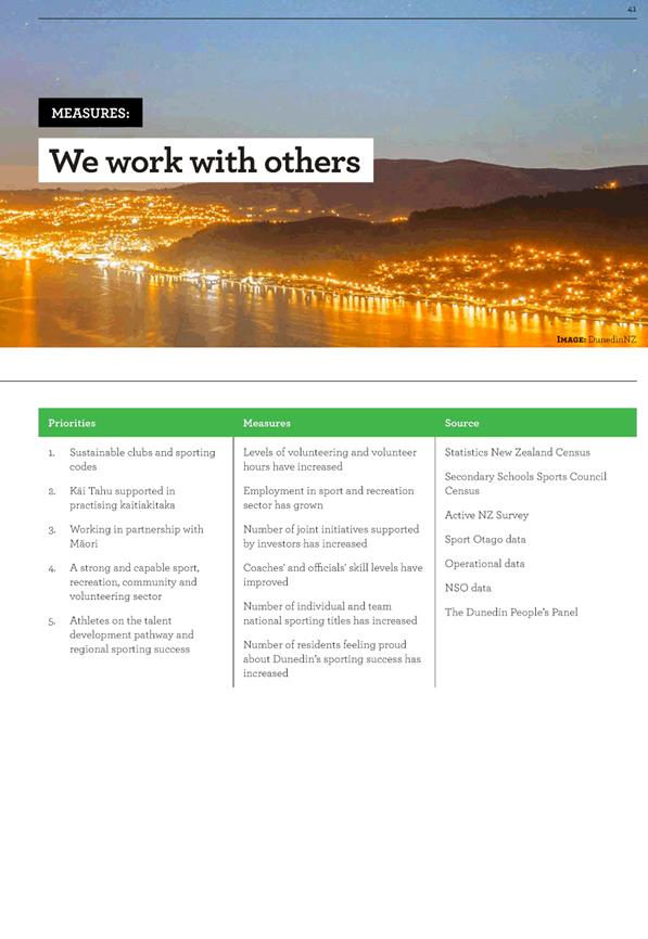
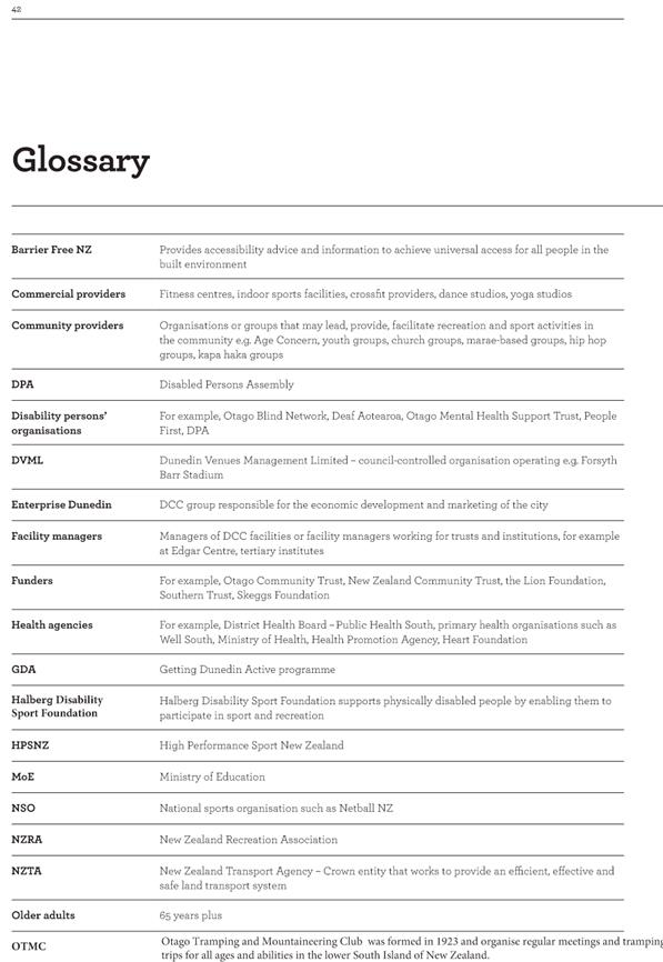
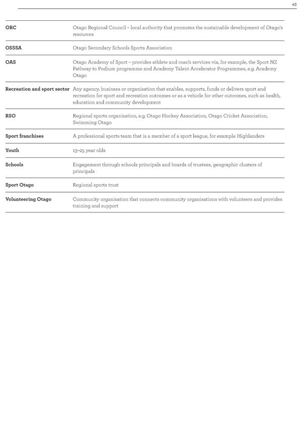
20 The Strategy and supporting action plans include measures to monitor
progress against the priorities set out in the Parks and Recreation strategic
framework.
21 There was overall support for the measures, however a number of
submitters considered that there needed to be a more specific biodiversity
measure in relation to Objective 3 ‘Our Parks, natural landscapes,
flora and fauna are treasured by the community’.
22 Staff have considered this comment in the context of the wider Councils’
strategic framework and consider that biodiversity monitoring and measuring is
sufficiently addressed within the Environment Strategy.
23 There
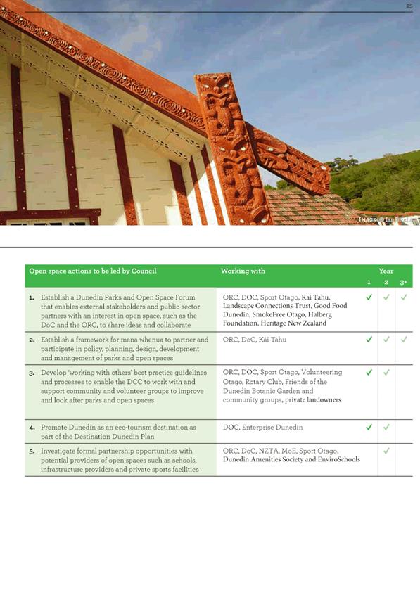
was support for the establishment of a Dunedin Parks and Open Space Forum to
enables external stakeholders and public sector partners to share ideas and
collaborate to deliver the Open Space Action Plan and monitor its progress.
24 Similarly,
there was support for a leadership group with representation from across the
sport and recreation sector to sponsor implementation of the Sport and
Recreation Action Plan and monitor its progress on behalf of the sector.
25 The
Forums will establish a monitoring and evaluation framework for the actions
based on the measures in this plan. Initiatives will be regularly monitored
during delivery and roles and responsibilities for actions reviewed at least
annually to respond to any changing circumstances.
Implementation Plan
26 To
enable the implementation of the Strategy, staff have begun to develop an
implementation plan (the Plan) based on the action plans within the strategy.
27 The
Plan will identify priorities, phasing and required resource to ensure
successful delivery and implementation of the Strategy over the next three
years. The Plan will form the basis of a three year work
programme (2017-2020) for the Parks and Recreation Group.
28 Staff
will regularly update the Infrastructure Services and Networks Committee on the
implementation of the Strategy as part of the Parks and Recreation Groups
Quarterly Report.
29 Where
the implementation plan identifies new initiatives, outside of the Parks and
Recreation Group’s current work programme and requires additional
operational and/or capital budgets these will be considered separately and as
part of the Long Term Plan (2018-2028).
OPTIONS
Option
One – Recommended Option
30 The
Infrastructure Services and Networks Committee recommends to the Council that
the Parks and Recreation Strategy (2016-2026), including the Sport and
Recreation Action Plan and Open Space Action Plan, is adopted at the 29 August
2017 Council meeting.
Advantages
· Aligns with the expectations of the key stakeholders and community
who have provided input and feedback into the direction and approach of the
Strategy.
· Enables the completion of the Dunedin City Council’s Strategic
Framework, as the Parks and Recreation Strategy is the last of the eight
strategies to be developed.
· Enables the actions to be incorporated into the Parks and Recreation
Group’s work programme, setting a clear direction for future planning,
development and management of Dunedin’s parks and recreation facilities
and assets.
Disadvantages
· There is a potential future ongoing operational and cost implication
to implement the actions identified within the Strategy.
Option
Two – Status Quo
31 The
Infrastructure Services and Networks Committee do not recommend to Council that
the Parks and Recreation Strategy (2016-2026) including the Sport and
Recreation Action Plan and Open Space Action Plan, is adopted by Council.
Advantages
· No potential for future ongoing operational and cost implications
Disadvantages
· Does not meet community and stakeholder expectations
· Delays the completion of the Dunedin City Council’s Strategic
Framework
· Delays the incorporation of the actions into the Parks and
Recreation Group’s work programme, presenting planning, policy and
operational risk to the organisation and its reputation.
NEXT STEPS
32 Following
adoption of the Strategy by Council, staff will proceed with finalising and
publishing the Parks and Recreation Strategy Document.
33 Staff
will also initiate the establishment of the Parks and Open Spaces Forum and the
Sport and Recreation Forums, aiming to convene the first meeting in September
2017. Staff will use these Forums to develop the Parks and Recreation Strategy
Implementation Plan.
34 Staff
will regularly update the Infrastructure Services and Networks Committee on the
implementation of the Strategy as part of the Parks and Recreation Groups
Quarterly Report.
Signatories
|
Author:
|
Rachael Eaton - Senior Recreation Planner
|
|
Authoriser:
|
Jendi Paterson - Recreation Planning and Facilities
Manager
Ruth Stokes - General Manager Infrastructure and
Networks
|
Attachments
|
|
Title
|
Page
|
|
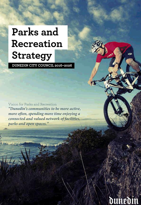
a
|
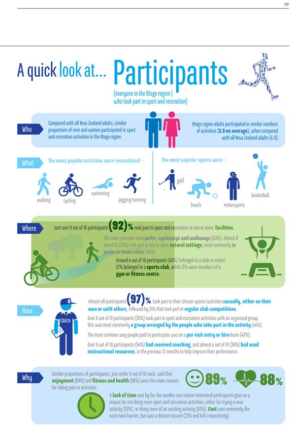
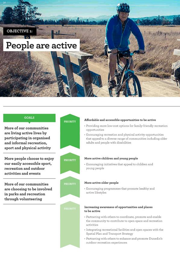
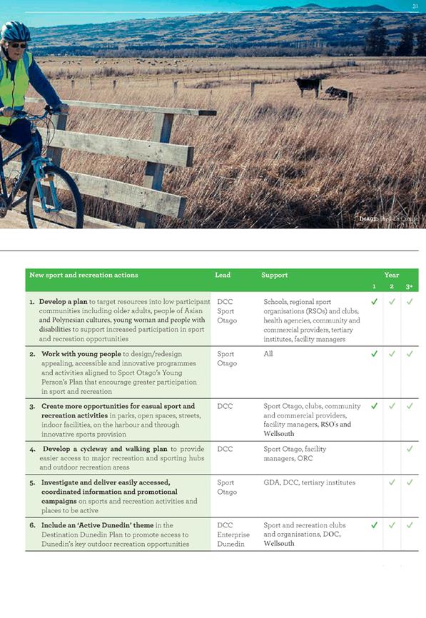
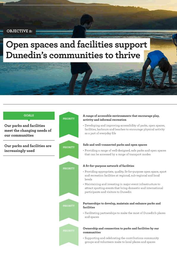
Parks and Recreation
Strategy 2016 -2026
|
48
|
|
b
|
Summary of Community
Consultation Feedback
|
93
|
|
SUMMARY OF CONSIDERATIONS
|
|
Fit with purpose
of Local Government
The Parks and Recreation Strategy will
assist the Council to meet the current and future needs of the Dunedin
community for good quality and cost-effective local infrastructure, local
public services and regulatory functions.
|
|
Fit with strategic
framework
|
|
Contributes
|
Detracts
|
Not applicable
|
|
Social Wellbeing Strategy
|
☒
|
☐
|
☐
|
|
Economic Development Strategy
|
☒
|
☐
|
☐
|
|
Environment Strategy
|
☒
|
☐
|
☐
|
|
Arts and Culture Strategy
|
☒
|
☐
|
☐
|
|
3 Waters Strategy
|
☒
|
☐
|
☐
|
|
Spatial Plan
|
☒
|
☐
|
☐
|
|
Integrated Transport Strategy
|
☒
|
☐
|
☐
|
|
Parks and Recreation Strategy
|
☒
|
☐
|
☐
|
|
Other strategic projects/policies/plans
|
☒
|
☐
|
☐
|
The Parks and Recreation Strategy
identify the recreational priorities and goals for the City’s strategic
framework and sets a clear direction that will inform the Council’s
projects, policies and plans.
The Strategy also contributes to the
Council’s existing strategies and plans.
|
|
Māori Impact
Statement
Staff consulted with Kāi Tahu in the
early development of the Strategy. Further consultation has occurred during
the development of the Implementation Plan.
|
|
Sustainability
The Strategy incorporates the principles
of sustainability of open space and recreation assets, and articulates the
Council’s environmental sustainability goals and priorities.
|
|
LTP/Annual Plan /
Financial Strategy /Infrastructure Strategy
The development of the Strategy is
consistent with the Long Term Plan and has no implications for the Annual
Plan, Financial or Infrastructure Strategy.
|
|
Financial
considerations
Any costs associated with the development
of the Strategy and Plans has been met from existing budgets. Financial
implications of potential initiatives identified in the Implementation Plan
will be assessed at the time of development.
|
|
Significance
This decision is considered to be of low
significance under the Significance and Engagement Policy.
|
|
Engagement –
external
Staff have engaged with a number of key
stakeholders during the development of the draft strategy. This includes the Otago Regional Council, Sport Otago, Department of Conservation, Kāi Tahu, Forest and Bird and Sport
New Zealand. There has been significant support from these stakeholders of
the proposed approach and direction set out in the Strategy and supporting
Action Plans.
|
|
Engagement -
internal
Feedback and input was sought on the
Strategy via a variety of meetings and briefings across Council departments
including Transport, Policy, Events and Community Development and with the
Strategy Advisory Group.
|
|
Risks: Legal /
Health and Safety etc.
There are no known risks.
|
|
Conflict of
Interest
There are no conflicts of interest.
|
|
Community Boards
Community Boards will be engaged in
implementation of the Strategy, as appropriate.
|
|
Infrastructure Services and
Networks Committee
14 August 2017
|
|

|
Infrastructure Services and Networks Committee
14 August 2017
|
|
|
Infrastructure Services and
Networks Committee
14 August 2017
|
|
|
Infrastructure Services and
Networks Committee
14 August 2017
|
|
|
Infrastructure Services and
Networks Committee
14 August 2017
|
|
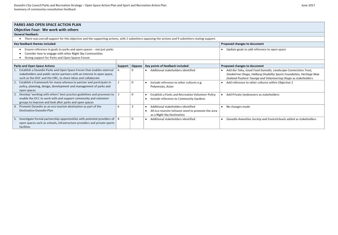
|
Infrastructure Services and
Networks Committee
14 August 2017
|
|
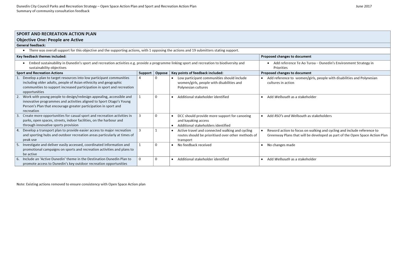
|
Infrastructure Services and
Networks Committee
14 August 2017
|
|
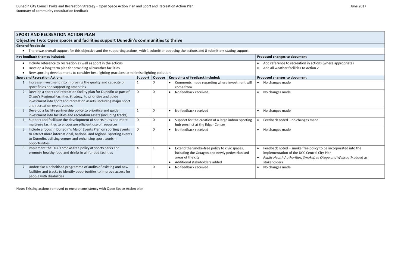
|
Infrastructure Services and
Networks Committee
14 August 2017
|
|
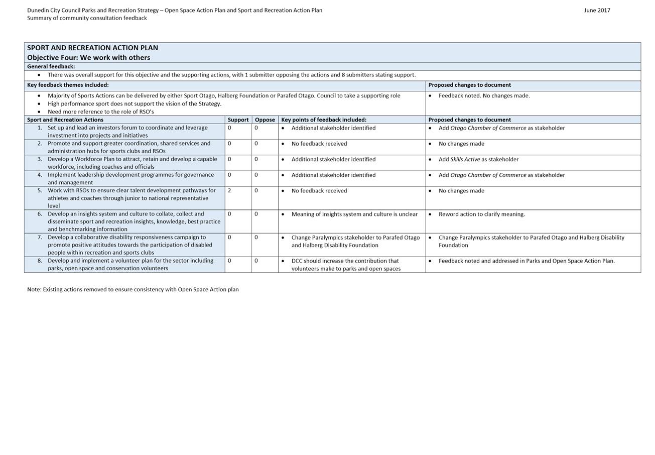
|
Infrastructure Services and
Networks Committee
14 August 2017
|
|
Proposal to name a new road off Riccarton Road
East
Department: Digital Services
EXECUTIVE SUMMARY
1 The
purpose of this report is to present the options for the naming of a new road
off Riccarton Road East as part of a residential development by AKGO
Limited.
2 The
developer's preference of road name complies with the Dunedin City Council Road
Naming Policy, however, the use of the preferred suffix "Wynd" is not
recommended.
|
RECOMMENDATIONS
That the Committee:
a) Decides
that the proposed road name “Wakefield Wynd” not be approved.
b) Approves the
use of ‘Wakefield’ for the name of the new road.
c) Decides that
the appropriate suffix for the new road is (Close / Place / Road /
Way).
d) Notes that
the Road Naming Policy will be updated to reflect the Australian and New
Zealand Rural and Urban Addressing Standards (AS/NZS 4819:2011).
|
BACKGROUND
3 A 17 lot
residential subdivision has been approved for 50 and 54 Riccarton Road East.
This subdivision will be serviced by a new road that will vest in
Council. The development is now at the stage the developer wishes to name
the new road.
4 At its
meeting of 14 June 2017 the Mosgiel Taieri Community Board considered a report
on the naming of the new road within the subdivision. The board recommended
that the Infrastructure Services and Networks Committee not approve the
application to name the new road "Wakefield Wynd".
DISCUSSION
5 The
Developer has proposed “Wakefield Wynd” as their preferred name for
this new road. No alternative names have been provided by the developer.
6 ”Wakefield”
was chosen as a reference to Edward Gibbon Wakefield (1796-1862).
Wakefield believed many of the social problems of Britain where due to
overcrowding and overpopulation and he saw emigration as a way of solving this
problem. He was involved schemes to settle both Canada and Australia
before becoming a director of the New Zealand Company in 1838. By the end
of 1839 he had dispatched nine ships to New Zealand. The company established
settlements at Wellington, Nelson, Wanganui and Dunedin. In 1843 the
company issued a prospectus for the sale of 48,000 hectares in a new settlement
called New Edinburgh at an undetermined location. In January 1844 a
160,000 hectare block was selected around Otago Harbour. The company
worked with the Free Church of Scotland and the first settlers sailed in
November 1847. Wakefield was heavily involved in the early settlement of
much of New Zealand. In January 1853 Wakefield arrived in New Zealand.
Initially landing in Christchurch, he soon relocated to Wellington. Here
he was elected to Parliament for Hutt, holding the seat until he resigned in
1855. He died in Wellington in 1862 and is buried in the Bolton Street
Cemetery.
7 The name
"Wakefield" fits the appropriateness criteria of the Road Name Policy
by use of a personal name for special service.
8 The name
"Wakefield" is not the same or similar to any other road name in
Dunedin.
9 The
suffix Wynd is frequently encountered in towns in Scotland and Northern
England. It derives from Old Norse Venda (to turn) implying a
turning off a main street. The old town of Edinburgh had many wynds,
until 19th century improvements led to them being widened and
renamed “streets”.
10 Currently
“Wynd” appears to have been used only once in New Zealand, and has
not been used previously within the boundaries of the Dunedin City Council
district. A “Wynd” is defined as "a narrow lane between
houses."
11 Acceptable road type
names are specified within the Australian and New Zealand Rural and Urban
Addressing Standards (AS/NZS 4819:2011).
The purpose of the addressing standard is to assign addresses that can be
readily and unambiguously identified and located. The standard is
intended for use by those agencies responsible for creating addresses, such as
Councils, where the addressing authorities enable them to propose addresses and
name roads. Wynd is not listed within this standard. While the
standard does not prohibit the use of names that are not listed, the use of the
suffix "Wynd" is a departure from existing naming protocols and
practices.
12 Wynd is not
considered to be a suitable description for a public road of normal width as
its meaning does not match the physical appearance or actual use of the
road. Additionally, the introduction of a new suffix description that the
general public are not familiar with may cause confusion around what
“Wynd” means, how it is pronounced and how it is spelled.
These factors would indicate it is not the most appropriate choice, and the
Committee may choose not to support the developer's proposal.
13 The Regional Manager
and Group Controller of Emergency Management Otago advised Council officers it
does not support the use of the suffix “Wynd” (as in Wakefield
Wynd) as the suffix is potentially confusing and they have a strong preference
for clarity as any confusion during a response, be it emergency services or a
wider local emergency situation, can put people at unnecessary risk.
14 A Senior Sergeant of
NZ Police confirmed any confusion around road naming can lead to a delay in
emergency response.
15 Land Information New
Zealand (LINZ) initially advised that they were strongly opposed to the use of
Wynd and would petition the Governor General to have the road renamed.
Council staff later received further advice that LINZ have withdrawn their
opposition.
16 The developer has
been advised that the application to use the suffix "Wynd" is not
supported by staff. At the time of writing this report no alternative
road name or suffix has been suggested by the developer.
OPTIONS
17 The road name
"Wakefield" complies with the road naming policy. The name
Wakefield is recommended for use but the suffix Wynd is not. As the
developer has not provided an alternative name the Infrastructure Services
Committee has the delegation to amend or decline the road name proposed.
Where the Committee wishes to amend the proposed name, the resolution of the matter
shall be left on the table to enable the amendment to be checked for compliance
with the road naming policy and to obtain the agreement of the proposer of the
name.
18 The road which is to
be named is a relatively short, standard width cul de sac. Using the Australian/New
Zealand Standard any of the following road types could be used as an
appropriate suffix:
a) Close –
Short enclosed roadway
b) Place –
Short, sometimes narrow, enclosed roadway
c) Road –
Open roadway primarily for vehicles
d) Way –
short enclosed roadway
19 Council staff
recommend using one of the Australia New Zealand approved suffixes such as
those listed above.
NEXT STEPS
20 Should the committee
accept the recommendation and decide on an alternative suffix for the road name
staff will contact to the developer to obtain agreement for the new name. The
naming process can then be completed.
21 Through this process
it was discovered that the DCC Road Naming Policy incorrectly used name
suffixes from a list supplied by New Zealand Post. The Policy will need
to be reviewed to refer instead to the Australia and New Zealand Rural and
Urban Addressing Standards (AS/NZS 4819:2011). The Policy Review will be
submitted for the Infrastructure Services Committee meeting of 14 August 2017.
Signatories
|
Author:
|
Bruce Hall - Information Support
|
|
Authoriser:
|
Richard Saunders - Group Manager Transport
Tracey Tamakehu - Chief Information Officer
|
Attachments
|
|
Title
|
Page
|
|
a
|
Site Plan
|
106
|
|
SUMMARY OF CONSIDERATIONS
|
|
Fit with purpose
of Local Government
This proposal relates to providing local infrastructure
and it is considered good-quality and cost-effective.
|
|
Fit with strategic
framework
|
|
Contributes
|
Detracts
|
Not applicable
|
|
Social Wellbeing Strategy
|
☐
|
☐
|
☒
|
|
Economic Development Strategy
|
☐
|
☐
|
☒
|
|
Environment Strategy
|
☐
|
☐
|
☒
|
|
Arts and Culture Strategy
|
☐
|
☐
|
☒
|
|
3 Waters Strategy
|
☐
|
☐
|
☒
|
|
Spatial Plan
|
☐
|
☐
|
☒
|
|
Integrated Transport Strategy
|
☒
|
☐
|
☐
|
|
Parks and Recreation Strategy
|
☐
|
☐
|
☒
|
|
Other strategic projects/policies/plans
|
☒
|
☐
|
☐
|
This is an administrative function.
|
|
Māori Impact
Statement
There are no known impacts for tangata whenua.
|
|
Sustainability
There are no implications for sustainability.
|
|
LTP/Annual Plan /
Financial Strategy /Infrastructure Strategy
There are no implications.
|
|
Financial
considerations
There are no financial implications.
|
|
Significance
The significance of the decision is low.
|
|
Engagement –
external
There has been engagement with the developer, Land
Information New Zealand, Civil Defense and Emergency Services.
|
|
Engagement -
internal
There has been no internal engagement.
|
|
Risks: Legal /
Health and Safety etc.
The Regional Manager and Group Controller of Emergency
Management Otago has stated that the suffix “Wynd” (as in
Wakefield Wynd) is potentially confusing and they have a strong preference
for clarity as any confusion during a response, be it emergency services or a
wider local emergency situation, can put the community at unnecessary risk.
|
|
Conflict of
Interest
There are no conflicts of interest.
|
|
Community Boards
The road is wholly within the Mosgiel Taieri Community
Board. The Board have recommended to the Committee that the application to
for Wakefield Wynd not be supported.
|
|
Infrastructure Services and
Networks Committee
14 August 2017
|
|
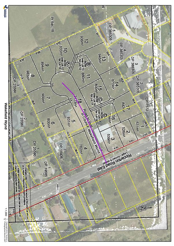
|
Infrastructure Services and Networks Committee
14 August 2017
|
|
Proposal to Name a New Private Way off
Glendermid Close, Sawyers Bay.
Department: Digital Services
EXECUTIVE SUMMARY
1 The
purpose of this report is to present the options for the naming of a new
private way off Glendermid Close as part of a residential development by
Sawyers Bay Ridge Limited. The developer's preference of road name
complies with the Dunedin City Council Road Naming Policy.
|
RECOMMENDATIONS
That the Committee:
a) Approves the
naming of a new private way off Glendermid Close as "Goddards Way".
|
BACKGROUND
2 A 13 lot
residential subdivision has been approved for 20A Fairview Terrace. This
subdivision will be serviced by a new private way off Glendermid Close.
The development is now at the stage the developer wishes to name the new road.
DISCUSSION
3 The
Developer has proposed "Goddards Way" as their preferred name for
this new private way. No alternative name has been suggested.
4 The
Goddard family owned this land from 1946 until 2005 and used it as a market
garden until 2013. The Goddard family were prominent in the community as market
gardeners for more than 60 years, and during that time employed many local
residents to harvest crops. The family still resides in Sawyers Bay.
5 The name
"Goddards" fits the appropriateness criteria of the Road Name
Guidelines by use of an historical person (or in this case family).
6 The name
"Goddards" is not the same or similar to any other road name in
Dunedin.
7 The
family has been contacted and given their permission for the name to be used in
this manner.
8 The road
name "Goddards" complies with the road naming policy.
9 The West
Harbour Community Board supported the proposed road name at their meeting on 19
July 2017.
OPTIONS
10 As the name complies
with the policy no options other than the recommendation have been presented.
NEXT STEPS
If the recommended name is approved, staff will process the
required documentation and advise the developer and Land Information New
Zealand of the new road name
Signatories
|
Author:
|
Bruce Hall - Information Support
|
|
Authoriser:
|
Richard Saunders - Group Manager Transport
Tracey Tamakehu - Chief Information Officer
|
Attachments
|
|
Title
|
Page
|
|
a
|
Location Map
|
110
|
|
SUMMARY OF CONSIDERATIONS
|
|
Fit with purpose
of Local Government
This proposal relates to providing local infrastructure
and it is considered good-quality and cost-effective.
|
|
Fit with strategic
framework
|
|
Contributes
|
Detracts
|
Not applicable
|
|
Social Wellbeing Strategy
|
☐
|
☐
|
☒
|
|
Economic Development Strategy
|
☐
|
☐
|
☒
|
|
Environment Strategy
|
☐
|
☐
|
☒
|
|
Arts and Culture Strategy
|
☐
|
☐
|
☒
|
|
3 Waters Strategy
|
☐
|
☐
|
☒
|
|
Spatial Plan
|
☐
|
☐
|
☒
|
|
Integrated Transport Strategy
|
☒
|
☐
|
☐
|
|
Parks and Recreation Strategy
|
☐
|
☐
|
☒
|
|
Other strategic projects/policies/plans
|
☒
|
☐
|
☐
|
This is an administrative function.
|
|
Māori Impact
Statement
There are no known impacts for tangata whenua.
|
|
Sustainability
There are no implications for sustainability.
|
|
LTP/Annual Plan / Financial
Strategy /Infrastructure Strategy
There are no implications.
|
|
Financial
considerations
There are no financial implications.
|
|
Significance
The significance of the decision is low.
|
|
Engagement –
external
There has been engagement with the developer.
|
|
Engagement -
internal
There has been no internal engagement.
|
|
Risks: Legal /
Health and Safety etc.
There are no risks.
|
|
Conflict of
Interest
There are no conflicts of interest.
|
|
Community Boards
The private way is wholly within the West Harbour
Community Board. The Board supports the proposed road name.
|
|
Infrastructure Services and
Networks Committee
14 August 2017
|
|
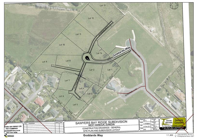
|
Infrastructure Services and Networks Committee
14 August 2017
|
|
Proposal to name a new private way off
Brighton Road, Waldronville.
Department: Digital Services
EXECUTIVE SUMMARY
1 The
purpose of this report is to present the options for the naming of a new
private way off Brighton Road, Waldronville as part of a residential
development by Sawyers Bay Ridge Limited. The developer's preference of
road name complies with the Dunedin City Council Road Naming Policy.
|
RECOMMENDATIONS
That the Committee:
a) Approves the
naming of a new private way off Brighton Road as “Catalina Lane”.
|
BACKGROUND
2 An 11 lot
residential subdivision has been approved for 275 Brighton Road. This subdivision
will be serviced by a new private way off Brighton Road. The development
is now at the stage the developer wishes to name the new private way.
3 The
developer has proposed “Victor Lane” as his preferred name and
“Vickers Lane”, Catalina Place” and “Hawker Lane”
as alternatives
DISCUSSION
4 Road
names in Waldronville follow a theme. They are named after aircraft and more
specifically aircraft in service in the 1950’s.
5 “Victor
Lane” is named for the Handley Page Victor, a British jet powered
strategic bomber that first flew in 1952 and entered service in 1958. It was
the third and final RAF V-bomber (the other two being the Avro Vulcan and the
Vickers Valiant, both already used for road names in Waldronville). Originally
a nuclear armed bomber it was retired from this role in 1968, and subsequently
used for strategic reconnaissance and aerial refuelling. The last Victor was
retired in 1993. The name "Victor" is not the same as any other road
name in Dunedin. However it is similar to Victoria Road, Victoria Street (2)
and Victory Place.
6 “Vickers
Lane”. Vickers Limited began manufacturing aircraft in 1911 and merged
with Armstrong Whitworth in 1927 to form Vickers-Armstrong. This was absorbed
into the British Aircraft Organisation in 1960. As the name of an aircraft
manufacturer it must be discounted as it does not fit the theme.
7 “Catalina
Place”. Named for the Consolidated PBY Catalina, an amphibian/flying
boat. First flown in 1935 it was retired by the US Navy in 1957 and by the
Brazilian Air Force in 1979. It was used in many roles including maritime
reconnaissance, air/sea rescue and anti-submarine warfare. More than 3300 were
built and several dozen still fly, mostly for aerial firefighting. It is not
the same or similar to any other name in Dunedin.
8 “Hawker
Lane”. Named for the Hawker Aircraft Corporation (later Hawker Siddeley).
This aircraft manufacturer built aircraft between 1920 and 1963. Similar to
Hawk Lane (Roslyn and St Leonards). As the name of an aircraft manufacturer it
must be discounted as it does not fit the theme.
9 The names
"Victor" and “Catalina” fit the appropriateness criteria
of the Road Name Guidelines by use of common or established theme.
10 Section 5.1 of the
Road Naming Policy states:
a) "5.1 New
road names shall not be the same as, or similar to, existing road names within
the City".
11 This would mean
“Victor Lane” may need to be discounted as being too similar to
Victoria Road, Victoria Street (2) and Victory Place.
12 The Saddle Hill
Community Board considered a report on the naming of this road at their meeting
on 13 July 2017. The Board supported naming the road “Catalina
Lane” which is a minor amendment to the option proposed by the developer.
OPTIONS
Option
1 - The Committee approves “Catalina Lane”
Advantages
· The
name complies with the policy in that there are no other similar road names.
Disadvantages
· This
is a minor amendment to one of the developer’s alternative choices for a
name.
Option
2 - The Committee approves “Victor Lane”
Advantages
· This
is the developer’s first choice for a name.
Disadvantages
· The
name does not comply with the policy due to the similarity in sound between
Victor Lane and the existing road names Victoria Street and Victory Place.
· There
may be confusion for emergency services, NZ Post and members of the public.
NEXT STEPS
13 If the recommended
name is approved, staff will process the required documentation and advise the
developer and Land Information New Zealand of the new road name.
Signatories
|
Author:
|
Bruce Hall - Information Support
|
|
Authoriser:
|
Tracey Tamakehu - Chief Information Officer
Richard Saunders - Group Manager Transport
|
Attachments
|
|
Title
|
Page
|
|
a
|
Location Map
|
115
|
|
SUMMARY OF CONSIDERATIONS
|
|
Fit with purpose
of Local Government
This proposal relates to providing local infrastructure
and it is considered good-quality and cost-effective.
|
|
Fit with strategic
framework
|
|
Contributes
|
Detracts
|
Not applicable
|
|
Social Wellbeing Strategy
|
☐
|
☐
|
☒
|
|
Economic Development Strategy
|
☐
|
☐
|
☒
|
|
Environment Strategy
|
☐
|
☐
|
☒
|
|
Arts and Culture Strategy
|
☐
|
☐
|
☒
|
|
3 Waters Strategy
|
☐
|
☐
|
☒
|
|
Spatial Plan
|
☐
|
☐
|
☒
|
|
Integrated Transport Strategy
|
☒
|
☐
|
☐
|
|
Parks and Recreation Strategy
|
☐
|
☐
|
☒
|
|
Other strategic projects/policies/plans
|
☒
|
☐
|
☐
|
This is an administrative function.
|
|
Māori Impact
Statement
There are no known impacts for tangata whenua.
|
|
Sustainability
There are no implications for sustainability.
|
|
LTP/Annual Plan /
Financial Strategy /Infrastructure Strategy
There are no implications.
|
|
Financial
considerations
There are no financial implications.
|
|
Significance
The significance of the decision is low.
|
|
Engagement –
external
There has been engagement with the developer.
|
|
Engagement -
internal
There has been no internal engagement.
|
|
Risks: Legal /
Health and Safety etc.
There are no risks.
|
|
Conflict of
Interest
There are no conflicts of interest.
|
|
Community Boards
The private way is wholly within the Saddle Hill Community
Board. The Board support the recommended name for the new road.
|
|
Infrastructure Services and
Networks Committee
14 August 2017
|
|
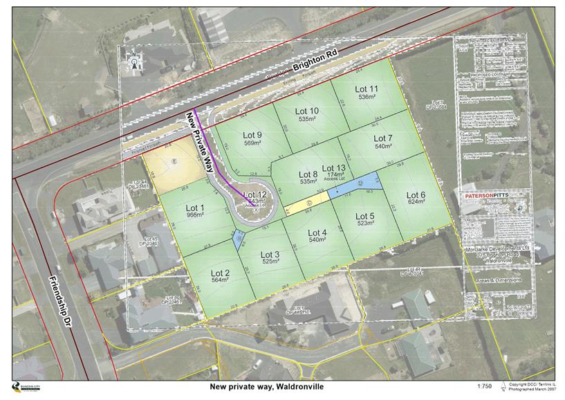
|
Infrastructure Services and Networks Committee
14 August 2017
|
|
Amendment to Road Naming Policy
Department: Digital Services
EXECUTIVE SUMMARY
1 The
purpose of this report is to recommend an amendment to the Dunedin City Council
Road Naming Policy.
2 The Road
Naming Policy (the Policy) provides guidance and clarity for the naming of
roads in Dunedin city. Staff recently discovered that the policy
incorrectly refers to road types in use by New Zealand Post. The road types
should refer to the list provided by the Australian/New Zealand Standard for
Rural and Urban Addressing.
|
RECOMMENDATIONS
That the Committee:
a) Approves an
amendment to the Dunedin City Council Road Naming Policy to reflect the road
types provided in the Australian/New Zealand Standard for Rural and Urban
Addressing (NZS 489:2011).
|
BACKGROUND
3 The Road
Naming Policy (the Policy) and Guidelines were adopted by the Infrastructure
Services Committee (the Committee) in December 2011.
4 At the
request of the Committee, staff amended the Policy and Guidelines in July 2016
to make the road naming criteria clearer to applicants.
DISCUSSION
5 In a
recent road name proposal the developer requested approval to use a road type
that did not appear in the approved road types listed in the Policy.
6 The
Policy currently states the road types list is not exhaustive and other road
types may be proposed by the developer if the road type appropriately describes
the proposed road. The Policy currently references a list of road types
based on those used by New Zealand Post and road types already in use in
Dunedin.
7 At the
time The Policy was written the road types listed were not standard in the
Australian/New Zealand Standard for Rural and Urban Addressing. The
standard is intended for use by those agencies responsible for creating
addresses, such as Councils, where the addressing authorities enable them to
propose addresses and name roads. The purpose of the addressing standard
is to assign addresses that can be readily and unambiguously identified and
located.
8 To avoid
ambiguity staff propose an amendment to the existing policy to replace the road
type list in the existing Policy with the road types approved by the
Australian/New Zealand Standard for addressing.
9 To ensure
consistency with the addressing standard, the following paragraph related to
Road Name Suffix on page 6 of the existing policy will be replaced:
Road Name Suffix – The road name
suffix for the road should be the one that most accurately reflects the type of
road that it is. A list of suggested suffixes and their meanings is
included in the table below. Note that this list is not exclusive –
other road name types can be used where their application is appropriate.
Road Names without a suffix are not uncommon in Dunedin,
but should only be used if necessary to accurately reference another name (e.g
Canongate is the name of an Edinburgh Street).
10 The new paragraph to
be included in the amended policy will be:
Road Type – The road type should
accurately reflect the type of road that it is. A list of road types and
their meanings is included in the table below. Only road types on the
list will be considered. Road names without a road type will not be
considered (e.g Canongate).
Historically allocated road types that do not meet the
addressing standard will not be changed unless the road is required to be
renamed for other reasons.
11 A copy of the
existing policy is included as Attachment A. A copy of the new table is
included as Attachment B.
OPTIONS
Option
One – Recommended Option
Amend the policy to reflect the road types provided in the
Australian / New Zealand Standards for Rural and Urban Addressing
Advantages
· The
policy will be consistent with the Australian/New Zealand Standard for Rural
and Urban Addressing
Disadvantages
· The
current policy will need to be amended and users advised of the change.
Option
Two – Status Quo
Do not amend the policy to reflect the road types provided
in the Australian / New Zealand Standards for Rural and Urban Addressing
Advantages
· No
change to current policy.
Disadvantages
· Inconsistent
with the Australian/New Zealand Standard for Rural and Urban Addressing
NEXT STEPS
12 If the amended
policy is adopted, Council officers will update the policy on the DCC website
and send copies of the amended policy to customers identified as regular users
of the process. Community Boards will also be advised of the change.
Signatories
|
Author:
|
Tracey Tamakehu - Chief Information Officer
|
|
Authoriser:
|
Richard Saunders - Group Manager Transport
Simon Pickford - General Manager Community Services
|
Attachments
|
|
Title
|
Page
|
|
a
|
Road Naming Policy June
2016
|
120
|
|
b
|
AS/NZS 4819:2011
Appendix B Road Types - New Zealand
|
134
|
|
SUMMARY OF CONSIDERATIONS
|
|
Fit with purpose
of Local Government
This decision/report/proposal relates to providing local
infrastructure and it is considered good-quality and cost-effective, by
ensuring road names are fit for purpose and allow for correct addressing for
use by emergency and postal services.
|
|
Fit with strategic
framework
|
|
Contributes
|
Detracts
|
Not applicable
|
|
Social Wellbeing Strategy
|
☐
|
☐
|
☒
|
|
Economic Development Strategy
|
☐
|
☐
|
☒
|
|
Environment Strategy
|
☐
|
☐
|
☒
|
|
Arts and Culture Strategy
|
☐
|
☐
|
☒
|
|
3 Waters Strategy
|
☐
|
☐
|
☒
|
|
Spatial Plan
|
☐
|
☐
|
☒
|
|
Integrated Transport Strategy
|
☒
|
☐
|
☐
|
|
Parks and Recreation Strategy
|
☐
|
☐
|
☒
|
|
Other strategic projects/policies/plans
|
☐
|
☐
|
☒
|
This policy outline advice on appropriate road naming and
is administrative.
|
|
Māori Impact
Statement
There are no known impacts for Māori.
|
|
Sustainability
There are no known impacts for sustainability.
|
|
LTP/Annual Plan /
Financial Strategy /Infrastructure Strategy
There are no known impacts as this is an administrative
function.
|
|
Financial
considerations
There are no known financial impacts.
|
|
Significance
The significance of the decision is low in terms of
Councils Significance and Engagement Policy.
|
|
Engagement –
external
There has been no external engagement.
|
|
Engagement -
internal
Transport have reviewed the amended policy.
|
|
Risks: Legal /
Health and Safety etc.
There are no known risks.
|
|
Conflict of
Interest
There are no known conflicts of interest.
|
|
Community Boards
The role of community boards are not changed by the
amended policy.
|
|
Infrastructure Services and
Networks Committee
14 August 2017
|
|
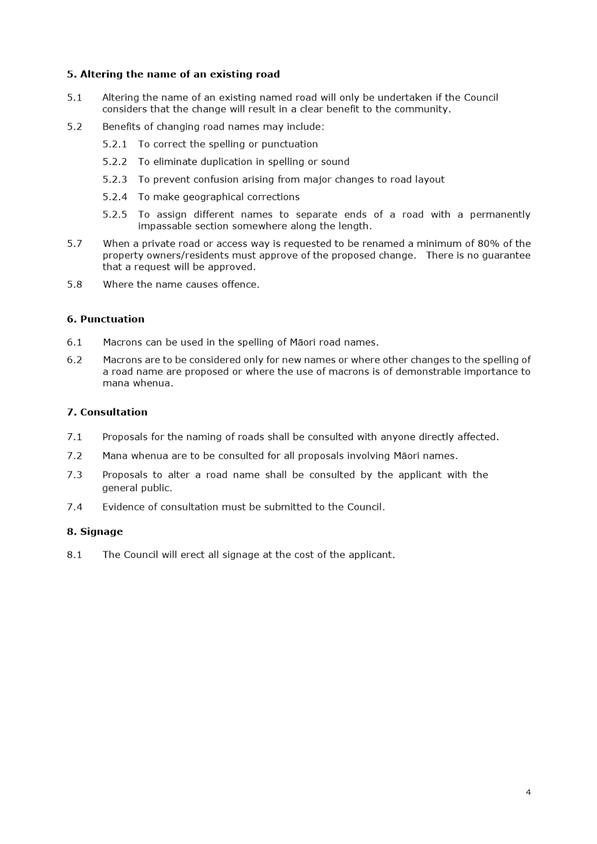

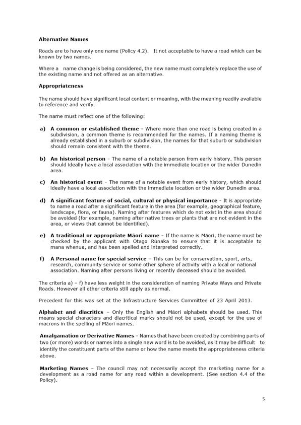
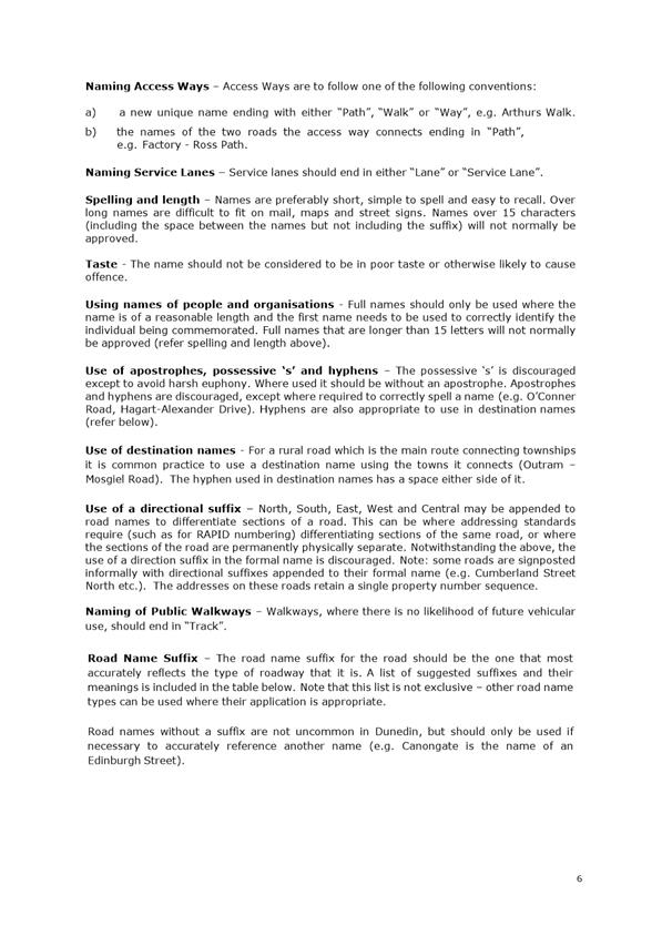
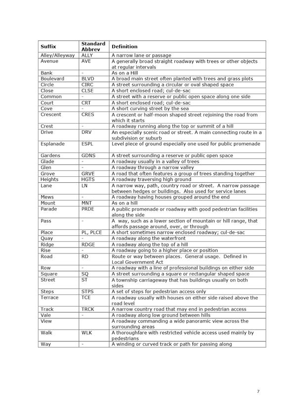
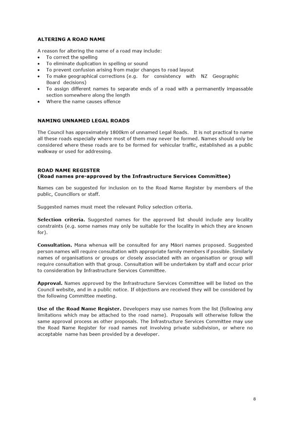
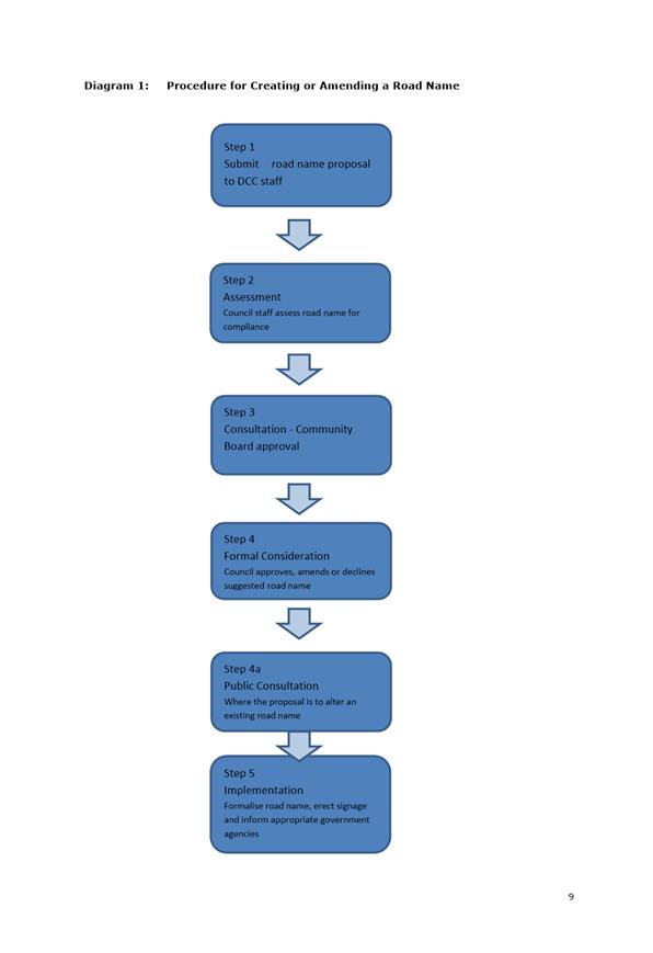
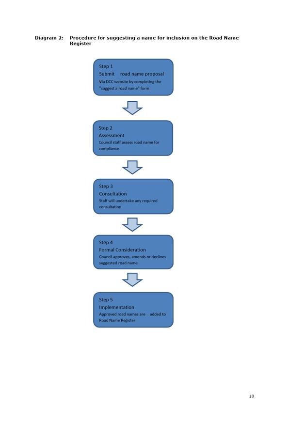
|
Infrastructure Services and Networks Committee
14 August 2017
|
|

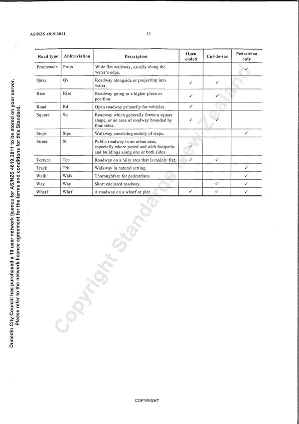
|
Infrastructure Services and Networks Committee
14 August 2017
|
|
Transport Activity Report for the Quarter
Ended 30 June 2017
Department: Transport
EXECUTIVE SUMMARY
1 This
report updates the Committee on Transport operations, maintenance and capital
works, including contracted out services.
2 Highlights
for the quarter include:
a) Capital
renewals for the 2016/17 year delivered to 100% programme budget.
b) A programme to
complete a full clean of the city’s mud tanks was completed in early
June.
c) Consultation
on the DCC urban cycle fund project has been completed with construction
planned for the 2017/18 year.
d) Procurement
for the 2017/18 capital renewals programme commenced prior to 1 July 2017.
|
RECOMMENDATIONS
That the Committee:
a) Notes the
Transport Activity Report for the Quarter ended 30 June 2017.
|
BACKGROUND
3 The
Transport activity provides the planning, construction, maintenance and
upgrading of the transport network. The network includes:
· roads
· cycle
ways
· footpaths
· bridges
and retaining walls
· street
lighting
· traffic
signals
· road
marking.
4 The New
Zealand Transport Agency (NZTA), the national road funding authority, provides
a financial assistance subsidy for works that meet agreed criteria via the
National Land Transport Programme.
DISCUSSION
Contract
Management
5 The
Transport Maintenance Contract was tendered in early 2016 and awarded to Downer
on 1 July 2016 for three years valued at $45 million.
6 Given the
tight timeframes in procuring the contract a six month transition period was
agreed with Downer. During this period performance measures and
underlying business processes were formally implemented and reported on from 1
January 2017. Performance results dictate the volume of renewal work that will
be awarded to Downer over the following year.
7 A robust
performance framework is now in place focusing on five key result areas as
follows:
a) Service
Delivery - Adherence to programme, specification and budget
b) Value for
Money – Delivering services efficiently
c) Customer
Service – Improved customer experience across all aspects of the contract
d) Safety –
Strict adherence to health and safety requirements and pro-active management of
health and safety issues
e) Collaborative
and Sustainable Working Environment – A business culture that encourages
innovation, initiative and sustainable work methods that protects and enhances
DCC's reputation.
Service
Delivery
8 Performance
is measured by network audit outcomes, adherence to programme delivery and
compliance with asset data and reporting requirements.
9 The
results in this area were acceptable during the period with strong performance
in programme quality and audit results. Improvements are required in the
measure of programme delivery.
10 The contractor
cleaned all of the mud tanks for the network by 30 June 2017.
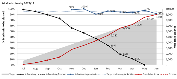
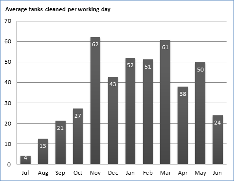
11 A decrease in the
percentage of compliant mud tanks in June was partly the result of auditors
focussing on the most at risk areas of the city. Additionally the period from
April to June produces the highest amount of leaf litter and sediment runoff.
The data captured during auditing is being used by Downer to refine the
cleaning programme for the 2017/18 year. There is a high level of confidence
that the mud tank network is being maintained to a high standard and will
perform as expected during a rain event.
12 Downer has improved
its planning and increased resources to achieve better delivery against the
programme in the 2017/18 year. While over 85% of the overall programme was
delivered in the 2016/17 year there were issues with delays to the delivery of
jobs which resulted in customer expectations not being met.
Value
for Money
13 Performance is
measured by inspection audits for work completed, co-ordination of corridor
access and the quality of claims.
14 Results in this area
have been unsatisfactory with a number of quality issues being identified by
staff. Downer has invested in staff training and independent auditing to ensure
the quality of delivery is improved with June results showing an improvement in
the quality of work undertaken.
15 The quality of
completed works will continue to be monitored to ensure compliance with
contract specifications. Payment is withheld for any works that do not
meet the required standards. Of the audited jobs presented in the June 2017
claim 16% were identified as not being to the appropriate specification and
payment was withheld.
16 Robust contract
monitoring processes are in place to ensure payment is only being made when the
work is completed to an acceptable standard and the appropriate claim has been
submitted to DCC.
Customer
Service
17 Performance is
measured by Customer Service Agency (CSA) response times and results from
customer satisfaction surveys sent to affected residents following road works.
18 Results in this area
for June were at an acceptable standard. 97% of CSA requests were
completed on time versus the targeted 95%.
19 Staff have
identified a gap in the current process where customers are not offered a call
back to update them on their request. Staff will work with the contractor
on the best process for addressing this issue.
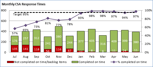
20 Council has
continued customer satisfaction surveys for residents living on roads included
in the 2016/17 renewal sites.
21 Feedback from these
surveys is being used to improve the process for future renewal programmes.
Issues identified through the surveys include a lack of road sweeping resulting
in excess chip on roads and footpaths and the general tidiness of sites.
Safety
22 Performance is
measured through Traffic Management Planning (TMP) audits, Health and Safety
audit results and reporting and record keeping for any health and safety
incidents.
23 Results in this area
have improved across the year.
24 Nineteen TMP audits
were undertaken in June by staff, with one incident of
non-conformance. The reason for the non-conformance was a lack of
adequate covering for a dig out site which was subsequently shut down and
addressed by the contractor.
25 Council has engaged
the services of an independent Health and Safety adviser who is undertaking
monthly health and safety site inspections. These are conducted in
collaboration with Council and Downer staff. Results in this area have
shown continual improvement. The first audit was conducted in April and
resulted in a scoring of 70%. The audit in June resulted in a scoring of
100%.
26 The process is also
designed to be a collective learning experience for those operational staff
involved by raising awareness and knowledge of potential health and safety
risks and appropriate process to mitigate.
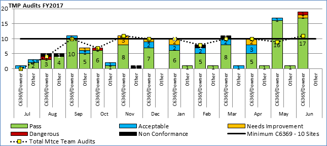
Major
initiatives
27 Peninsula
Connection Safety Improvement Project – The second public open
day for the Peninsula Connection was held on 26 July. This workshop is to
present the detailed design to the public and seek any final feedback prior to
the tender process commencing. Key points to note in the final design are as
follows:
· The
design for the Peninsula includes a 1.2m shoulder, 3m vehicle lane and a 3m
shared path between Vauxhall and Portobello. From Portobello the design
includes a 0.7m shoulder, 3m vehicle lane and a 2.5m shared path. These designs
will provide the greatest safety improvements for all road users. A copy of the
cross sections is included as Attachment A.
· Following
feedback from the last open day a new rounded edge separator has been designed.
This separator will be installed for all new sections and all existing
separators will be replaced. This new design addresses concerns from cyclists
and drivers regarding the existing sharp edged separators.
· The
order of construction for the project is still to be confirmed through the
tender process. At this stage it is anticipated that construction will commence
at the city end of the route. The rationale for this is that the greatest
safety benefits are realised in the areas with the highest traffic counts. In
this case the highest counts are at the city end of the Peninsula. Staff are
aware of the preference of many Peninsula residents to provide connections
between the main residential areas. Discussions will be held with contractors
to explore whether there are options available to achieve this.
28 An expression of
interest process for contractors was completed in June. A good response was
achieved and early engagement is now occurring with these contractors. The
competitive tender process will commence in August with physical works expected
to start in October.
29 Regional Land
Transport Plan – A paper is being provided to the Committee to
approve the Council submission to the Regional Land Transport Plan.
30 Urban Cycleway
Programme – A consultation process has been completed for the Urban
Cycleway programme. This programme includes a number of routes to provide
better connections around the harbour and from the harbour to the city. A
summary of the feedback received and resulting changes to designs is being
presented in a separate report to the Committee.
31 Transport Model –
The new traffic model is on track to be delivered by the end of the calendar
year. This will be a significant asset for the city as we consider projects
such as the Central City Plan. The model includes a micro-simulation of the
central city to assist with detailed traffic modelling.
32 Capital Renewals
2016/17 – The capital renewal programme for the 2016/17 year was
completed to 100% of budget. Significant progress has been made addressing
deferred maintenance on seawalls, bridges and retaining walls. There has also
been significant investment in car parks at our parks and reserves and other
key sites such as the Railway Station to bring these up to an acceptable level
of service. Discussions with Parks and Recreation and Parking Operations are
ongoing to ensure these levels of service are maintained.
33 LED Street Light
Installation – A procurement process has commenced to appoint a
design lead for the LED renewal project. In addition staff have been
working with NZTA and other councils to identify efficiencies to benefit
renewal projects. Discussions on an approved 3000 kelvin light fitting have
been positive which should assist with the NZTA business case process.
34 Safety
improvement projects – Following a significant underspend on safety
improvement projects in 2015/16 staff have been working on a number of packages
to deliver during the 2016/17 and 2017/18 years. A number of safety improvement
projects were undertaken resulting in 100% of budget spent. Projects
included:
· Citywide
safety improvement package focussing on making crossings accessible for all
road users.
· Puddle
Alley/Dukes Road intersection upgrade.
· An
upgrade of Allanton Road at the intersection of Scroggs Hill which had a poor
safety record.
· Implementation
of a number of minor safety improvements at schools to improve student safety.
· Installation
of three new speed indicator signs. This brings the total number of signs to
six. They are moved around various sites across the city where speeding has
been identified as an issue.
· A
safety improvement project at Westwood to provide safe access to residents and
encourage reduced speed.
· The
installation of 3D crossings in the tertiary precinct to improve safety for
pedestrians.
35 A number of
additional safety improvement projects are confirmed and will be tendered for
construction in early 2017/18 subject to funding being available. These
include:
· Baldwin Street safety improvements
· Victoria / Forbury / Bedford intersection upgrade
(roundabout)
· Wharf Street / Roberts Street intersection upgrade
· Town belt traverse pedestrian safety improvements
· South Dunedin intersection improvements
· Playfair
Avenue / South Road (Caversham) intersection improvements
· Installation
of a package of roundabouts at the Green Island / Fairfield motorway
interchange in conjunction with NZTA
· Installation
of safety barriers on the Otago Peninsula to improve safety for drivers
· A
further package of crossing improvements to improve accessibility on the
network.
OPTIONS
36 As an update report
there are no options.
NEXT STEPS
37 Areas of focus for
the next quarter will be:
· Working
with Downer to improve performance in year two of the contract with an emphasis
on delivery of the programme and quality of work.
· Procurement
of capital works for the 2017/18 year with 75% of all works to be tendered by
30 September 2017.
· Completion
of the Highcliff Road slip repairs and safety improvements.
· Completion
of the first draft of the Transport Asset Management Plan to support NZTA's
next three year funding round.
· Begin
the procurement process for the Peninsula Connection Safety Improvement
Project.
· Progress
design and procurement for the Urban Cycleway work package.
· Complete
the Council submission to the 2018/19 to 2021/22 Regional Land Transport Plan.
Signatories
|
Author:
|
Merrin McCrory - Asset and Commercial Manager, Transport
|
|
Authoriser:
|
Richard Saunders - Group Manager Transport
Ruth Stokes - General Manager Infrastructure and
Networks
|
Attachments
|
|
Title
|
Page
|
|
a
|
Peninsula Connection
Cross Sections
|
145
|
|
SUMMARY OF CONSIDERATIONS
|
|
Fit with purpose
of Local Government
This report relates to providing local infrastructure and
it is considered good-quality and cost-effective.
|
|
Fit with strategic
framework
|
|
Contributes
|
Detracts
|
Not applicable
|
|
Social Wellbeing Strategy
|
☒
|
☐
|
☐
|
|
Economic Development Strategy
|
☒
|
☐
|
☐
|
|
Environment Strategy
|
☒
|
☐
|
☐
|
|
Arts and Culture Strategy
|
☐
|
☐
|
☒
|
|
3 Waters Strategy
|
☐
|
☐
|
☒
|
|
Spatial Plan
|
☒
|
☐
|
☐
|
|
Integrated Transport Strategy
|
☒
|
☐
|
☐
|
|
Parks and Recreation Strategy
|
☒
|
☐
|
☐
|
|
Other strategic projects/policies/plans
|
☒
|
☐
|
☐
|
The Integrated Transport Strategy supports the outcomes of
a number of strategies.
|
|
Māori Impact
Statement
No known impacts.
|
|
Sustainability
The Integrated Transport Strategy supports sustainable
outcomes.
|
|
LTP/Annual Plan /
Financial Strategy /Infrastructure Strategy
The Integrated Transport Strategy is included in the long
term plan.
|
|
Financial
considerations
No financial implications.
|
|
Significance
This is considered to be of low significance in terms of
the Council’s Significance and Engagement Policy.
|
|
Engagement –
external
No external engagement.
|
|
Engagement -
internal
No internal engagement.
|
|
Risks: Legal /
Health and Safety etc.
No risks.
|
|
Conflict of
Interest
No conflict of interest.
|
|
Community Boards
Not applicable.
|
|
Infrastructure Services and
Networks Committee
14 August 2017
|
|
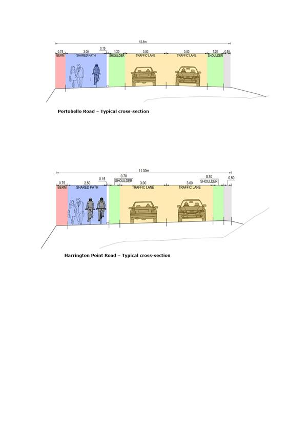
|
Infrastructure Services and Networks Committee
14 August 2017
|
|
Proposed Consultation Dunedin City Speed
Limits Bylaw Amendment 8
Department: Transport
EXECUTIVE SUMMARY
1 Council
has completed a speed limit review in Dunedin of the following roads in
Dunedin:
a) The Esplanade,
St Clair
b) Three Mile
Hill, Half Way Bush
c) Shetland
Street, Wakari
d) Wingatui Road,
Mosgiel
e) Gladstone Road
North, Mosgiel.
2 The speed
limit review identified four roads where a permanent speed limit change is
recommended, and one road where a variable speed limit change is recommended.
3 The
objective of the review is to recommend the most appropriate safe speed limit
for each road taking into account the level of use, roadside development and
surrounding environment, as well as being credible to road users and nationally
consistent.
4 Council
staff recommend postponing the inclusion of any roads identified as requiring
”challenging conversations” in this amendment due to the need for a
more robust engagement process, in accordance with the new New Zealand
Transport Agency Speed Management Guide.
5 Council
staff also recommend postponing the extension of the 40 km/h variable speed
limit on Shetland Street at Wakari School until such time as we return to
Council with an approach to speed limits around all schools in the Dunedin
area.
|
RECOMMENDATIONS
That the Committee:
a) Decides that a bylaw is the most appropriate way of
addressing the control of speed in the following locations: The Esplanade, St Clair, Wingatui Road, Mosgiel and Gladstone Road North, Mosgiel.
b) Approves that
the Statement of Proposal for Amendment 8 to the Dunedin City Council Speed
Limits Bylaw 2004 be publicly notified for consultation during the period 1
September 2017 to 1 October 2017.
c) Decides that
a Hearings Committee of 3 Councillors be appointed to hear and consider any
submissions received and report recommendations back to the Council.
d) Approves of
postponing proposed speed limit changes on Three Mile Hill Road which is
identified as requiring “challenging conversations” due to the
need for engagement as per the new New Zealand Transport Agency Speed
Management Guide
e) Approves of
postponing any changes to variable speed zones around Wakari School pending a
review of a consistent approach to speed limits around schools in the Dunedin
area.
f) Requests
Council staff report back to the Infrastructure Networks and Services
Committee regarding the adoption of consistent speed limits around schools.
|
BACKGROUND
6 Land
Transport Rule 54001: ‘Setting of Speed Limits 2003’ established
procedures that enable road controlling authorities to set enforceable speed
limits on roads within their jurisdiction.
7 The power
to set a speed limit is limited to road controlling authorities that have the
power to make bylaws concerning the use of roads under the Local Government Act
2002, or power to make bylaws under specific legislation, e.g. airport
authorities.
8 Council
established a new speed limit bylaw, the Dunedin City Speed Limits Bylaw in
2004, following the change in legislation giving road controlling authorities
the responsibility of setting speed limits.
9 Any
changes to speed limits are required to be carried out in accordance with Land
Transport Rule: Setting of Speed Limits 2003 and the special consultative
process in the Local Government Act 2002 prior to adoption by Council, as an
amendment to the Dunedin City Council Speed Limit Bylaw 2004.
10 Speed limit reviews
have been ‘on hold’ pending changes by NZTA in the approach to
speed management.
a) This new
approach to speed management is outlined in the Speed Management Guide, which
was released in November 2016 with a roll out of workshops for road controlling
authorities in March 2017.
b) The
submissions of the Draft Land Transport Rule: Setting of Speed Limits 2017
closed on 16 June 2017 and is anticipated to be adopted in the next few months.
11 NZTA is supportive
of proceeding with speed limit reviews under the current rule, if it is clear
that the speed limit changes proposed are not controversial and are supported
by the following principles as set out in the Speed Management Guide:
a) Evidence-based
b) A national
consistent approach
c) Prioritise
high benefit areas that improve both safety and economic productivity, and also
areas that will contribute to the credibility of speed management
d) Achieve value
for money
e) Build better
understanding between road controlling authorities and the public for speed
management.
12 The speed limit
review was undertaken in accordance with Land Transport Rule 54001: Setting of
Speed Limits 2003, as is legally required, considering both level of
development and safety.
13 The
Rule requires the speed limit to be calculated using the rating method
incorporated in the Speed Limits New Zealand (SLNZ) Rule. This rating method
calculates speed limits based on the intensity of roadside development, with
the objective of ensuring there is a national consistency in setting speed
limits that reflects the urban vs. rural environment, as shown in Table 1.
Table 1
Speed limits derived from rating
|
Environment
|
Rating
|
Rated speed limit
|
|
Towns,
main centres
|
>11
|
50
|
|
Smaller
settlements, major divided roads
|
6-11
|
70
|
|
Rural
undivided roads with minimal development
|
3-6
|
80
|
|
Rural
roads
|
<3
|
100
|
14 While the level of
development is considered a fundamental determinant of speed limits, the Rule
(Clause 3.2(5) a) enables road controlling authorities to set a speed limit
that is different to the calculated one, if it is the safe and appropriate
speed limit for the road. The process for determining safe and appropriate
speeds is more complex than the rating method and is outlined in Attachment A.
15 The Rule also allows
for 40 kilometres per hour variable speed limits to operate at the start and
end of the school day. Attachment B summarises the criteria for a 40 kilometres
per hour variable speed limit near urban schools which includes traffic speed
and traffic volume outside the schools.
DISCUSSION
16 Three
road sections were initially reviewed for permanent speed limit changes. In the
process of reviewing these road sections:
a) One road section,
Three Mile Hill, is recommended to be postponed as the appropriate intervention
is unclear without first engaging with the community. The current vehicle
speeds are above what is considered “safe and appropriate” so it is
identified as requiring “challenging conversations” on either
reducing the speed limit or engineering the road up to the current speed limit.
b) One additional
road section, Gladstone Road North, was identified as meriting a speed limit
change as it intersects the road section of Wingatui Road that is under review,
and had similar characteristics to Wingatui Road.
c) The review of
speed limits on all the four roads has been completed and changes are
recommended to three of them as summarised in Tables 2 below. Attachment C
contains a more detailed synopsis of the review. Attachment D & E contains
maps of the recommended permanent speed limit changes.
Table 2 Proposed speed limit changes
and rationale
|
Ref
|
Location /Road Name
|
Road section
|
Speed Limit (km/h)
|
|
current
|
proposed
|
|
Shared use reserve roads[1]
in Dunedin’s urban area – reduce speed limit to 30 km/h to match
operating speeds & high pedestrian & cyclist use
|
|
1
|
Esplanade, St Clair
|
Forbury to Beach
|
50
|
30
|
|
Urban expansion in East
Mosgiel - reduce speed limit to 50 km/h to match urbanisation
|
|
2
|
Wingatui Road
|
From Gladstone Road to 100m south of Factory Rd
|
70
|
50
|
|
3
|
Gladstone Road North
|
From 100 m east of Wingatui Rd to 50/70 sign 165 m
west of Wingatui Rd & 90 m n/o Gladstone (to No. 214)
|
70
|
50
|
|
|
|
|
|
|
Table 3 Roads where no change is recommended at this
time
|
Road
|
Section
|
Proposal &
rationale
|
|
Three Mile Hill
Road
|
50/70 sign to 70/80 sign (457 metres) plus 100 metres
of Dalziel Road, south of Three Mile Hill Road
|
Request for this
70 km/h section to become 50km/h.
Recommendation: This section of road is prioritised
under the Second Priority intervention (along with Dalziel Road) with both
road sections identified with interventions requiring “challenging
conversations”. It is not a “self-explaining road” and
unclear the best approach for addressing the safety concerns. For this
reason, it is recommended to go through the new engagement process
recommended by NZTA and under the new Rule.
|
17 As a part of DCC
Speed Limit Bylaw Amendment 7 in 2014, five schools were found to meet the
requirements for a 40 kilometres per hour variable speed limit. One of these
schools requires an extension of the zone to more appropriately define the
school zone. Table 4 lists the school, the proposed school section (school
zone) to which 40 kilometres per hour variable speed limit is to apply, as well
as the times of operation. Attachment F shows the school zone as a map.
Table 4
Proposed 40 km/h variable school zone speed limit
|
Ref
|
School
|
Road sections of school zone
|
40 km/h variable
speed limit
Hours of operation
(school days only)
|
|
1
|
Wakari School
|
Shetland
Street
· Extend an additional 115 metres to the
south
|
8.40am – 9.00am
3.00pm – 3.15pm
|
18 Council staff
recommend postponing consultation on proposed changes to Shetland Street
outside Wakari School pending a review of speed limits around all schools, in
order to develop a consistent safety approach.
19 Attachment G
outlines the process of reviewing speed limits, step by step. The current
review is at Step 5 of 16; the formal steps and key dates are listed in Table 5
below.
Table 5
Formal Steps and key dates
|
Step
|
Task name
|
Date
|
|
5
|
Initiate Formal Process
|
14
August 2017 (This Meeting)
|
|
6
|
Public consultation
|
1 September -1 October 2017
|
|
7
|
Hearings Committee convened
(if required)
|
October/November 2017
|
|
11
|
Council Resolution
|
16 November 2017
|
|
16
|
Amendment 8 take effect
|
February 2018
|
20 Public consultation
on the proposed Amendment 8 to the Speed Limits Bylaw is Step 6 on the Speed
Limit Review process in Attachment G. This will be advertised by way of public
notice and media publicity. Directly affected parties will be contacted and
invited to submit. These parties include affected residents, the affected school,
NZ Police, and the New Zealand Transport Agency.
21 In addition, all
community boards will be consulted, including those that are not directly
affected by the proposed changes.
22 The Statement of
Proposal for Amendment 8 to the Dunedin City Council Speed Limits Bylaw 2004 is
in Attachment H. It includes the Proposed Amendments text and maps that will
become part of the bylaw, as well as a summary of the Statement of Proposal and
a submission form for consultation.
23 As this speed limit
review is relatively small, the estimated cost for installing permanent speed
limit signs is such that it will be funded under the current maintenance
contract.
OPTIONS
Option
One – Recommended Option
24 The recommended
option is to proceed with the public consultation process for a permanent
speed limit changes to the following three roads under the current speed
management rules;
· The
Esplanade, St Clair
· Wingatui
Road, Mosgiel
· Gladstone
Road North, Mosgiel.
Advantages
· Speed
in affected areas will be reduced, which will improve safety for all road
users.
· Speed
limit changes that are recommended in this report are appropriate for the
roadside environment.
· Speed
limit changes will not be delayed or caught up as part of the transition to the
new rule that is anticipated to be adopted later this year.
Disadvantages
· Changes
to the speed limit on Wingatui Road, and the adjoining section of Gladstone
Road North, would raise discrepancies with the NZTA’s Speed Management
Maps, as they have not been identified as roads of highest priority, due to the
recent transition from rural residential to residential.
· Speed
limit changes to The Esplanade would not be consistent with the NZTA’s
Speed Management Maps, however, the changes would be consistent with other main
centres based on the Esplanade’s “high place function and
concentration of active users” as per the new Speed Management Guide.
Option
Two – Status Quo
25 The status quo would
be to leave these speed limits unchanged and wait for the adoption of the new
NZTA Land Transport Rule: Setting of Speed Limits 2017.
Advantages
· Speed
limit reviews would be prioritised using the new evidence-based approach.
· The
new process for speed limit reviews includes engagement and collaboration with
the community and key stakeholders.
· The
new approach to speed management looks to address the problem within the road
corridor and speed limit changes may be one of many options discussed.
Disadvantages
· Delays
in speed limit changes would mean speed limits in Wingatui Road and Gladstone
Road North sections would not fit the changed road environment.
NEXT STEPS
26 The next step in the
speed limit review process is public consultation for one month (proposed for 1
September – 1 October) followed by a public hearing in October/November
2017.
27 Staff will report
back to the Committee regarding the adoption of consistent speed limits around
schools.
Signatories
|
Author:
|
Lisa Clifford - Senior Transportation Engineer
|
|
Authoriser:
|
Richard Saunders - Group Manager Transport
Ruth Stokes - General Manager Infrastructure and
Networks
|
Attachments
|
|
Title
|
Page
|
|
a
|
Technical Process for
Determining Speed Limits
|
155
|
|
b
|
Selection Criteria for
Traffic Control Devices near Schools
|
156
|
|
c
|
Table of Proposed
Permanent Speed Limit Changes
|
157
|
|
d
|
Map of Proposed
Permanent Speed Limit - Esplanande
|
160
|
|
e
|
Map of Proposed
Permanent Speed Limit - Wingatui Road and Gladstone Road
|
161
|
|
f
|
Map of Proposed
Variable Speed Limit - Wakari School
|
162
|
|
g
|
Speed Limit Review -
Key Steps
|
163
|
|
h
|
Statement of Proposal -
Amendment 8 to the DCC Speed Limit Bylaw 2004
|
165
|
|
SUMMARY OF CONSIDERATIONS
|
|
Fit with purpose
of Local Government
This proposal relates to providing a regulatory function
and it is considered good-quality and cost-effective.
|
|
Fit with strategic
framework
|
|
Contributes
|
Detracts
|
Not applicable
|
|
Social Wellbeing Strategy
|
☒
|
☐
|
☐
|
|
Economic Development Strategy
|
☐
|
☐
|
☒
|
|
Environment Strategy
|
☐
|
☐
|
☒
|
|
Arts and Culture Strategy
|
☐
|
☐
|
☒
|
|
3 Waters Strategy
|
☐
|
☐
|
☒
|
|
Spatial Plan
|
☒
|
☐
|
☐
|
|
Integrated Transport Strategy
|
☒
|
☐
|
☐
|
|
Parks and Recreation Strategy
|
☐
|
☐
|
☒
|
|
Other strategic projects/policies/plans
|
☐
|
☐
|
☒
|
Ensuring Dunedin is a safe city which is prioritised in
the Social Wellbeing Strategy, Spatial Plan and Long Term Plan as well as the
Integrated Transport Strategy. Safer speeds is one of the four pillars under
the Safe System approach to reduce the number of fatal and serious injury
crashes occurring on Dunedin’s road network.
|
|
Māori Impact
Statement
There are no known impacts for tangata whenua
|
|
Sustainability
No implications for sustainability
|
|
LTP/Annual Plan /
Financial Strategy /Infrastructure Strategy
There are no implications for the above plans and
strategies.
|
|
Financial
considerations
The financial cost for the recommended option is minimal
and can be covered through the current maintenance contract.
|
|
Significance
There is community interest in making the changes
identified in Amendment 8 regarding road safety.
|
|
Engagement –
external
No external engagement has been undertaken, but community
views will be sought as part of the engagement exercise.
|
|
Engagement -
internal
No internal engagement has occurred.
|
|
Risks: Legal /
Health and Safety etc.
The proposed speed limit changes will “treat”
the risk by reducing speeds to fit the road environment. For the roads where
a change is not recommended risk would not be treated simply by a change in posted
speed limits. Further interventions to treat any risk adequately will
be assessed and developed using the new Speed Management Guidelines.
|
|
Conflict of
Interest
No conflicts of interest have been identified.
|
|
Community Boards
All community boards will be invited to participate in the
community engagement process where speed limit changes are proposed to roads
within their areas.
|
|
Infrastructure Services and
Networks Committee
14 August 2017
|
|
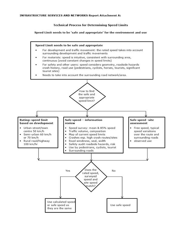
|
Infrastructure Services and Networks Committee
14 August 2017
|
|
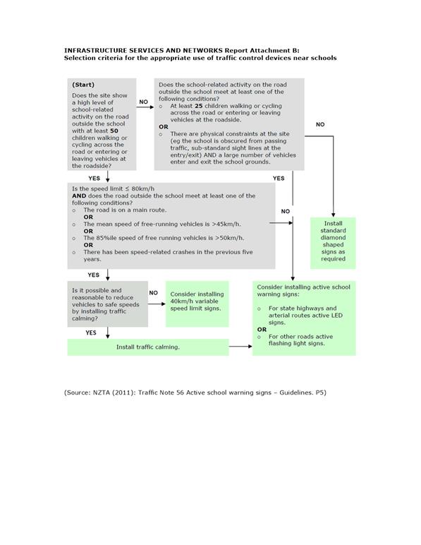
|
Infrastructure Services and Networks Committee
14 August 2017
|
|

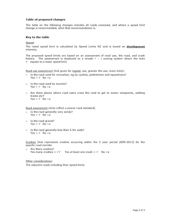
|
Infrastructure Services and
Networks Committee
14 August 2017
|
|
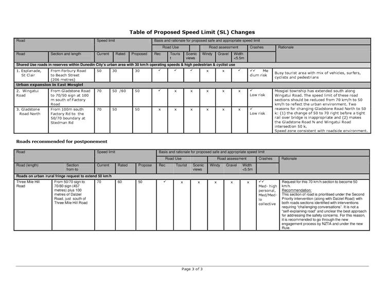
|
Infrastructure Services and
Networks Committee
14 August 2017
|
|
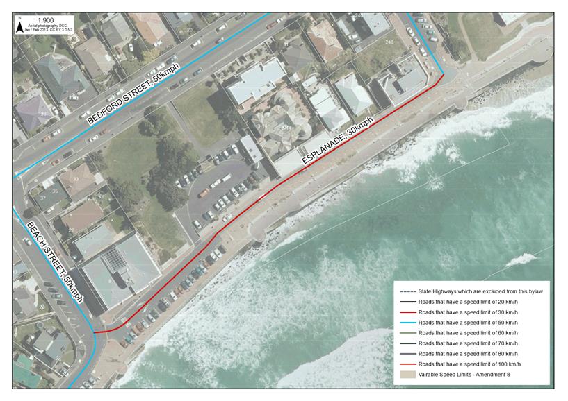
|
Infrastructure Services and Networks Committee
14 August 2017
|
|
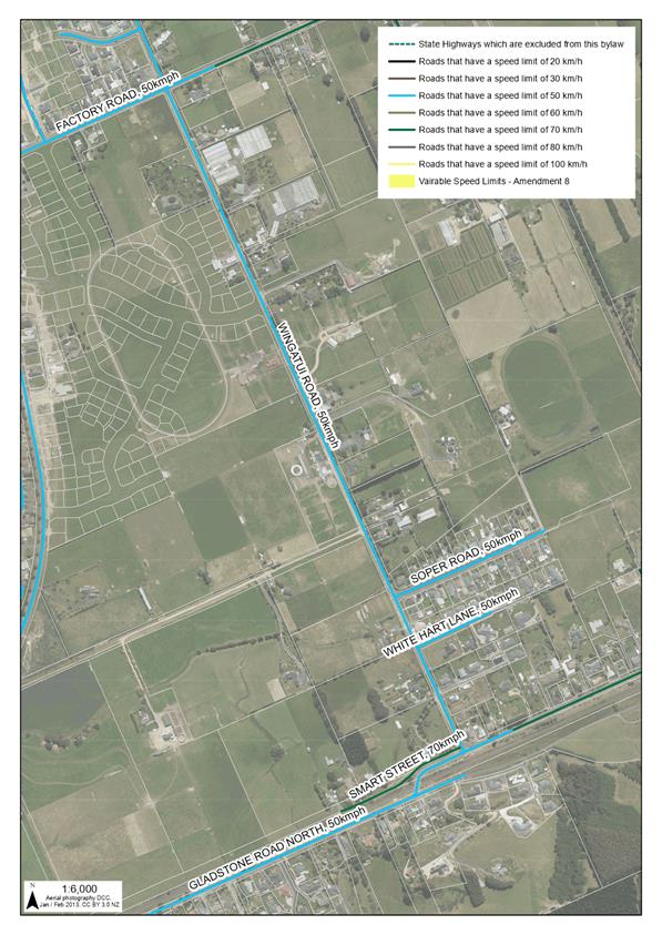
|
Infrastructure Services and Networks Committee
14 August 2017
|
|
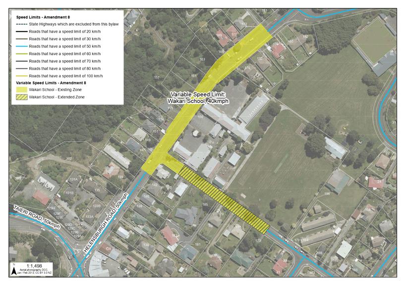
|
Infrastructure Services and Networks Committee
14 August 2017
|
|
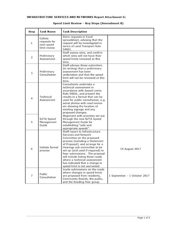
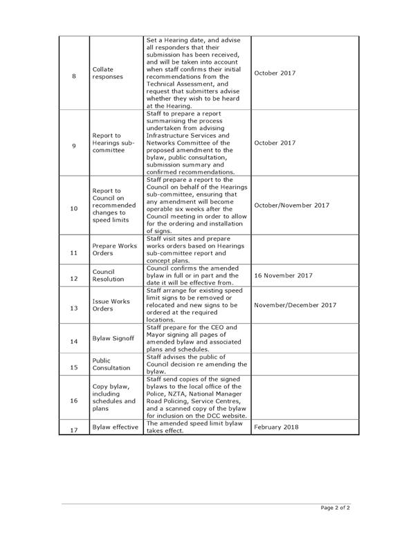
|
Infrastructure Services and Networks Committee
14 August 2017
|
|
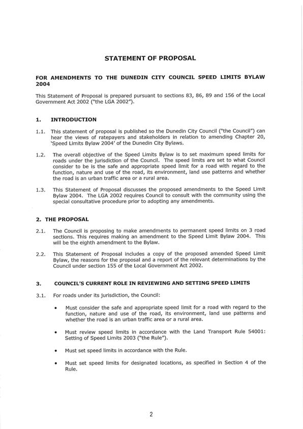
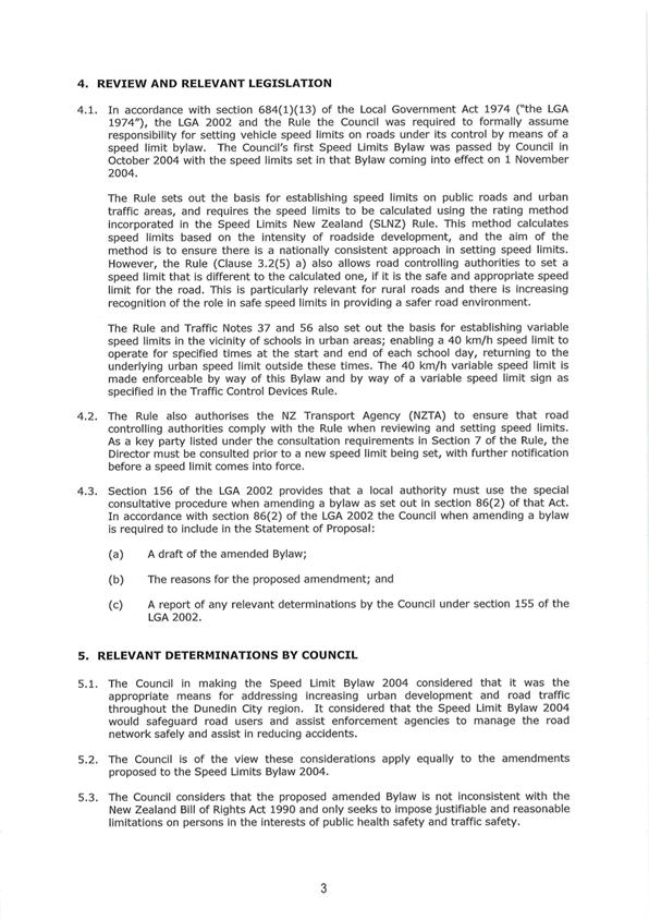
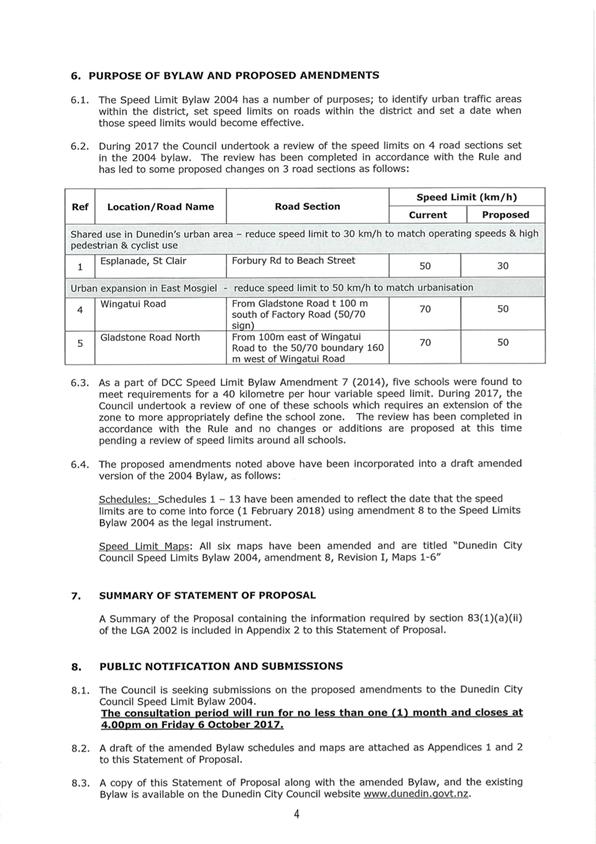
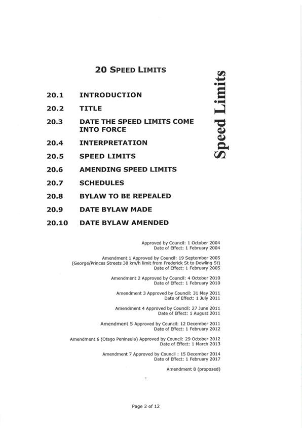
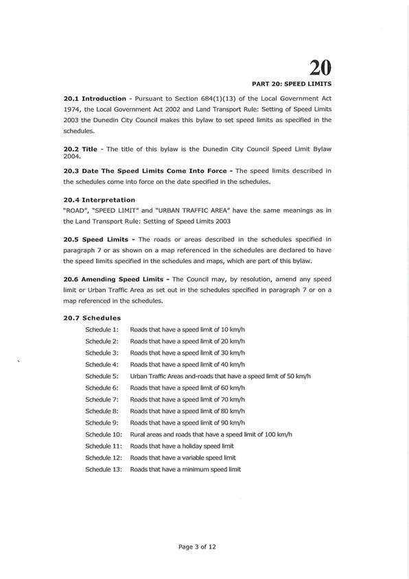
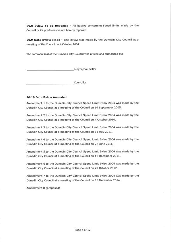
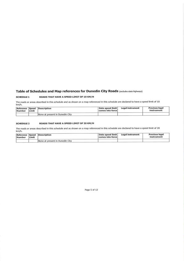
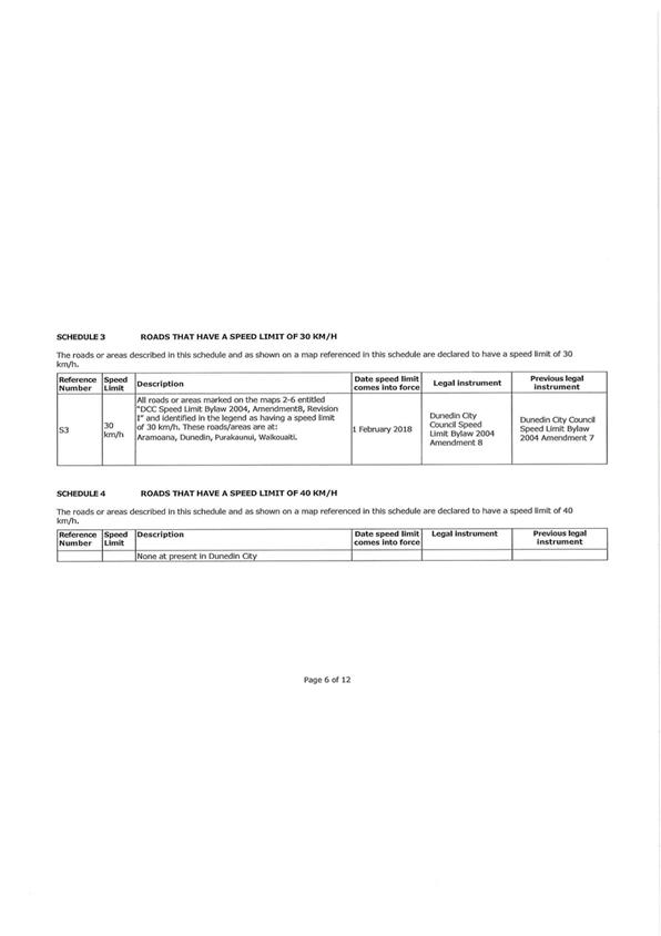
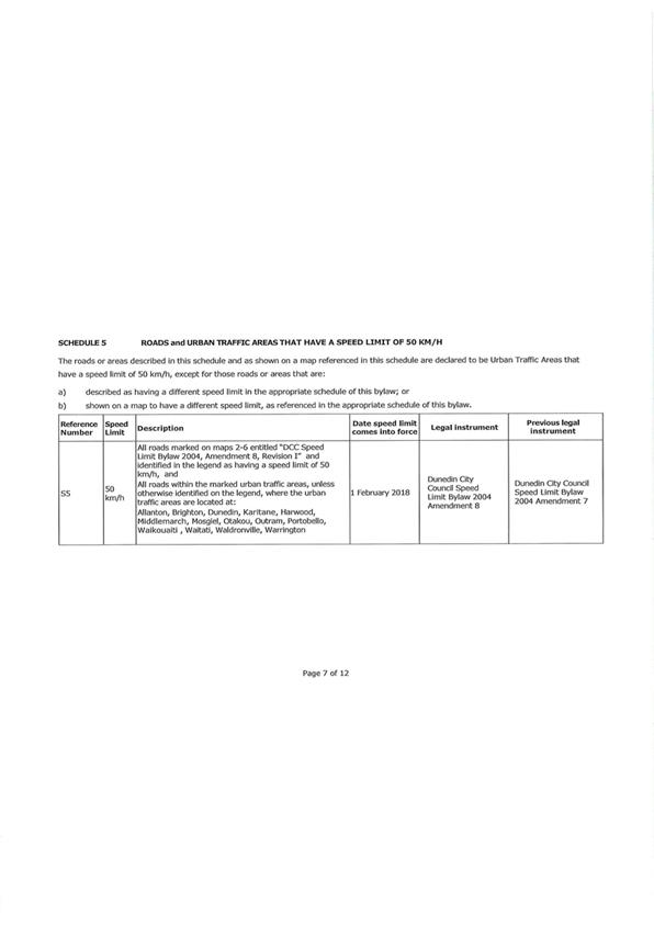
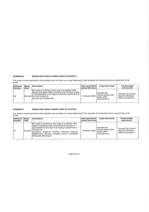
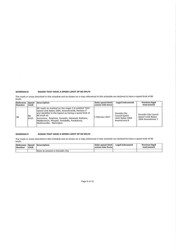
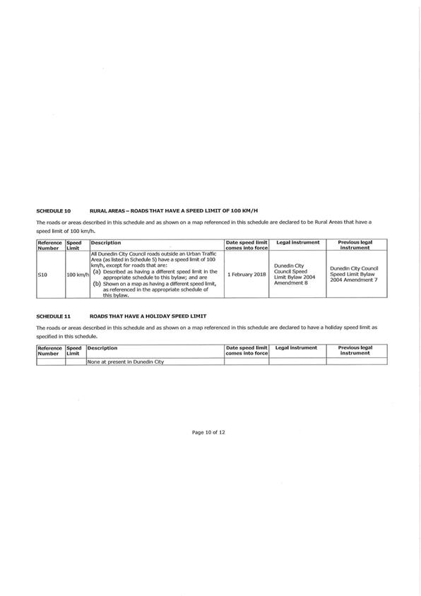
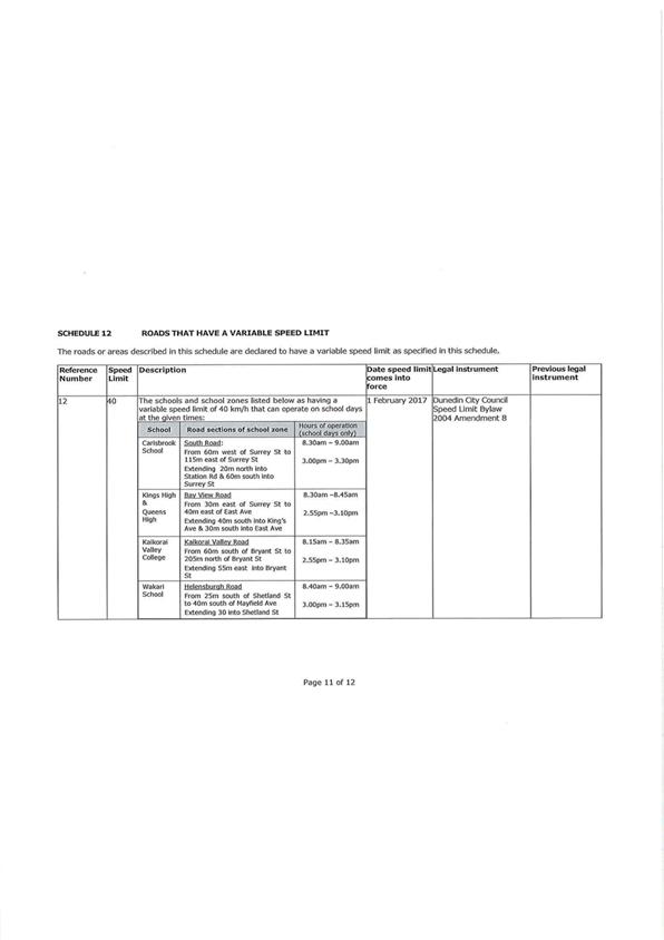
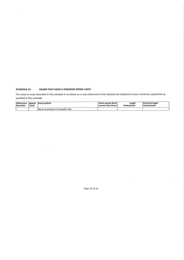
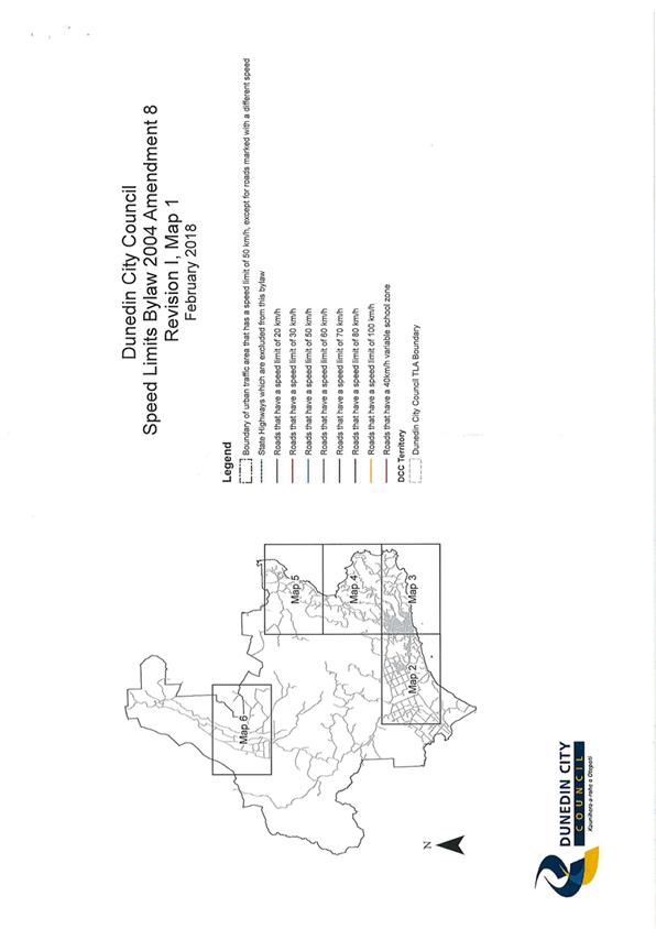
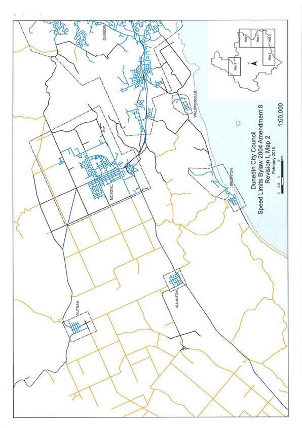
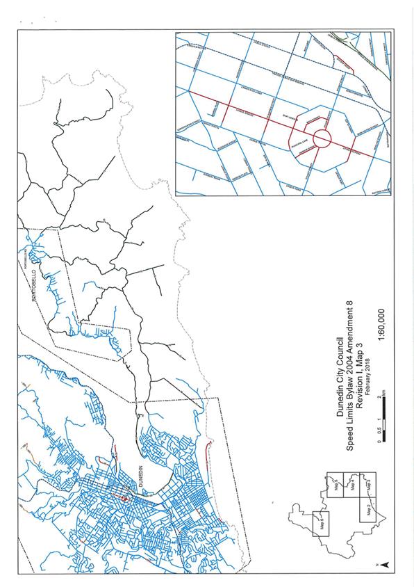
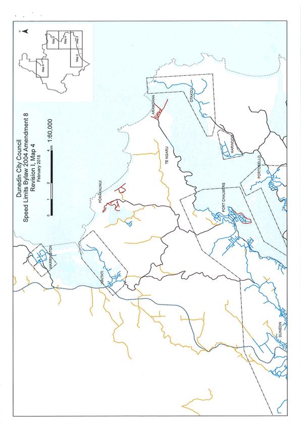
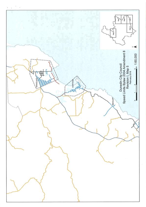
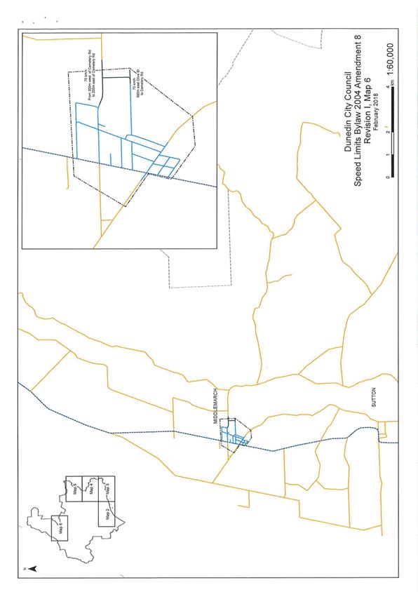
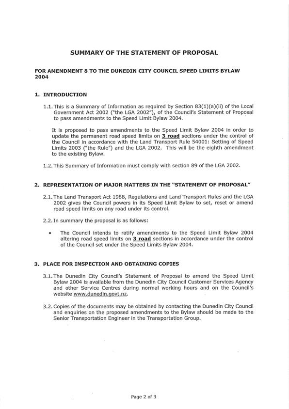
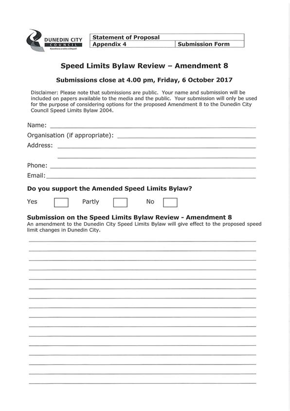
|
Infrastructure Services and Networks Committee
14 August 2017
|
|
Update on the NZTA Speed Management Guidelines
Department: Transport
EXECUTIVE SUMMARY
1 This
report presents the New Zealand Transport Agency (NZTA) Speed Management
Guide which was adopted in November 2016. The Guide is a tool
designed to assist the NZTA and Road Controlling Authorities (RCAs) to better
determine the road risks that will feed into the development of speed
management approaches for communities that address identified risks and meet
their needs.
2 This
report recommends that the DCC follow the methodology in the Guide to
prioritise speed limit reviews and develop a forward works programme to be
included in the next three year Long Term Plan (LTP).
3 It is
recommended that the Committee approve the new approach to speed limit reviews
based on the Speed Management Guide.
|
RECOMMENDATIONS
That the Committee:
a) Notes the
new NZTA Speed Management Guide adopted in November 2016.
b) Adopts the
NZTA Speed Management Guide for implementing DCC speed limit reviews.
|
BACKGROUND
4 The power
to set a speed limit is limited to road controlling authorities (RCAs) that
have the power to make bylaws concerning the use of roads under the Local
Government Act 2002, or power to make bylaws under specific legislation, e.g.
airport authorities.
5 Council
established a new speed limit bylaw, the Dunedin City Speed Limits Bylaw in
2004, following the change in legislation giving road controlling authorities
the responsibility of setting speed limits.
6 Any
changes to speed limits are required to be carried out in accordance with Land
Transport Rule: Setting of Speed Limits 2003 and the special consultative
process in the Local Government Act 2002 prior to adoption by Council as an
amendment to the Dunedin City Council Speed Limit Bylaw 2004.
7 Speed
limits have historically been reviewed every other year due to the complexity
of the process. The last speed limit review was in 2014.
8 Speed
limit reviews have been ‘on hold’ pending changes by NZTA in the
approach to speed management.
9 Safer
Speeds is one of the four pillars under Safe Systems. The others are Safer
Roads and Roadsides, Safer Vehicles and Safer Drivers.
10 The Guide is
a tool as a part of the Safe System Approach which recognises that people make
mistakes but should not die or be seriously injured as a result of those
mistakes.
11 The Guide
fulfils part of the 2012-2015 Safer Journeys Action Plan, which outlines a
multi-sector approach to establishing a safe and efficient road system for New
Zealanders.
12 The Guide
sits under the Safer Speeds Programme, an initiative that aims to help
New Zealanders choose the right speed for the road.
13 In March 2017, NZTA
introduced the new approach to speed management through a series of workshops
for RCAs which was attended by Transport staff.
14 The new Road
Safety Risk Mapping tool associated with the Guide is to be released in
late July 2017, and there will be communication sent to RCAs to support the
release.
15 Consultation on the
Land Transport Rule 54001: “Setting of Speed Limits 2017” closed on
16 June 2017 and will replace the 2003 rule.
16 The Ministry has
indicated it is keen to get the new Rule finalised as soon as possible, which
could be as soon as the end of August 2017.
17 The new 2017 Rule
will use the tools in the new Speed Management Guide to determine the safe and
appropriate speed for a given section of road.
DISCUSSION
18 The objective of
NZTA’s Speed Management Guide is to provide a nationally
consistent approach to speed management.
19 The Guide
will assist local councils to prioritise ‘high benefit’ speed
management opportunities.
20 The Guide
supports a new conversation on road risk and speed through engagement.
21 In
conjunction with the Guide, a predictive road assessment methodology has
been designed to proactively assess road safety risk in the form of a GIS map
tool called Speed Management Maps.
Speed Management Framework
22 Speed management is
about achieving safe and appropriate speeds that reflect road function, design,
safety, and use.
23 Speed management
should be targeted to two areas:
a) To reduce
deaths and serious injuries, and improve economic productivity;
b) Where there
are high benefit opportunities to improve the credibility of speed limits.
These will be corridors where road users already travel at the safe and
appropriate speed, but the posted speed limit is out of alignment.
24 The Speed Management
Framework provides a single assessment method for determining safe and
appropriate speeds on New Zealand’s entire road network. It provides the
opportunity to better align travelling speeds with road function, design,
safety, and use because the One Network Road Classification (ONRC) takes
traffic volumes, freight volumes, and place functions into account.
25 Current speed
frameworks and speed management processes were developed when there was no
overarching road classification system. This has resulted in some routes where
travel speeds are not appropriate to road use and function.
26 The Speed Management
Framework sets out safe and appropriate speed ranges taking into account road
function, design, safety, and use. The Guide steers RCAs to where the
highest benefit opportunities lie on their networks.
Draft Speed Management Maps
27 The New Zealand
Transport Agency will provide for each RCA a draft Speed Management Map of
their network, which will:
a) show where the
existing speed limits differ most from the Framework’s safe and
appropriate speeds
b) identify where
the greatest benefits from applying speed management will be achieved.
28 A draft Speed
Management Map will help an RCA to determine:
a) where
infrastructure improvements should be targeted to improve safety and efficiency
b) where a review
of the speed limits should be considered
c) where there is
a high risk, but likely to be ‘challenging conversations” with the
public and stakeholders, because current traffic speeds are not safe or
appropriate but this does not self-explain well to communities and road users
d) lower priority
areas, but where action might be required in the future.
29 A draft Speed
Management Map:
a) better aligns
travel speeds with traffic volumes, freight volumes, and place functions, as
part of an integrated one network approach (consistent with the One Network
Road Classification Framework)
b) will show
where it is best to invest in safety improvements in order to make high risk
corridors safer at current travel speeds, and where it is more efficient to
manage speed down, while also supporting better engagement in speed management.
30 Four types of
interventions are identified to address speed management. They are:
a) “Engineer
up” is the intervention recommended for the economically important
roads where the safety performance is poor, and there is a strong case for
investment to bring the corridor up to the required standard to support
existing or higher travel speeds. Here travel speeds will tend to be close to
the existing speed limit, or possibly higher.
b) “Challenging
conversations” are the corridors where current travel speeds and the
speed limit are above the calculated safe and appropriate speed and the safety
performance is poor. However, in these instances, the criterion for engineering
up is not satisfied, even though the safest performance justifies some sort of
intervention. In these cases road users are travelling too fast for the safety
conditions of the corridor, and the intervention may require a lowering of the
current speed limit, either permanently or on an interim basis until the
investment can be justified, or the safety performance improves. These are
defined as “challenging conversations” because the discussions
around lowering limits can often be challenging, and the RCAs need to be
prepared for careful and sometimes extended community engagement and
consultation.
c) “Self-explaining”
are the corridors where the posted speed limit is higher than the safe and
appropriate speed, but where road users are already travelling at the safe and
appropriate speed. These are the high benefit opportunities because lowering
the speed limit will be self-explanatory and credible to road users. This helps
to improve community understanding of safe and appropriate speeds, and improves
the credibility of speed limit settings. It also helps to explain roads better
to visiting drivers.
d) “Potential
increase” is the intervention for a few corridors nationwide where it
is recommended to increase speeds to 110 kilometres per hour.
Early Engagement
31 Speed is a highly
sensitive topic and the approach to implementation can be as, if not more,
important and challenging as the technical analysis.
32 The Speed Management
Maps (when finalised) will be a starting point for consideration, but we also
need to take into account local knowledge, engage with the community and then
move to formal consultation if intervention is needed.
33 The engagement
approach is to have a productive conversation on the safety concerns, noting
some roads are difficult to read and not safe at their current limits.
34 The objective of
engagement is to build public understanding of road risk resulting in safer
choices by communities and individuals.
Formal consultation and the Rule
35 Formal consultation
is still required and needs to comply with the Land Transport Rule: Setting of
Speed Limits 2003 until such time as the new Rule 2017 is adopted.
36 RCAs still need to
carry out assessments under the Rule.
Forward Works
37 The Speed Management
Maps have identified the First Priority (top 5%) and Second Priority (next 5%)
of corridors where interventions are recommended.
38 Puddle Alley was the
only corridor identified within Dunedin City Council’s local road network
that recommends “engineering up”. Safety improvements to Puddle
Alley are currently underway and have received additional funding from NZTA to
complete the works.
39 The remaining
emphasis for safety improvements will focus on roads identified as needing
“challenging conversations” to determine the most appropriate
approach to safety concerns.
40 The Speed Management
Maps have identified three corridors in this category within Dunedin City
Council’s local roads as being in the First Priority (top 5%). They are:
a) Brighton Road,
north of Allen Street to Blackhead Road
b) Three Mile
Hill Road, from Flagstaff-Whare Flat Road to Silverstream Valley Road
c) Princes
Street, south of Dowling Street
41 The Speed Management
Maps have also identified the Second Priority corridors as shown:
a) Dalziel Road
b) Three Mile
Hill Road, from north of Taieri Road (50/70 k sign) to north of Dalziel Road
(70/80 sign
c) Blackhead
Road, from Middleton Road to Brighton Road
d) Maclaggan
Street, from Broadway to Graham Street
e) Allanton Road,
from Hwy 86 to Granton Road
f) Morris Road
(west of Coalsgate Road to east of Chain Hills Road)
g) Portobello
Road (Cove to Collinswood and between MacAndrews Bay and Broad Bay)
h) Highcliff Road
(east of Hilton Road to west of Camp Road). Safety improvements are currently
underway for this corridor.
OPTIONS
There are no options to consider as part
of this proposal.
NEXT STEPS
42 Council staff will
provide feedback to NZTA on the draft Speed Management Maps.
43 Council staff will
use the draft Speed Management Maps as a tool for prioritisation of safety
interventions.
44 Staff will look to
develop a forward works programme, with emphasis of the road corridors whose
interventions are described as “challenging conversations”.
45 Staff will include
these corridors in the next three year LTP.
Signatories
|
Author:
|
Lisa Clifford - Senior Transportation Engineer
|
|
Authoriser:
|
Merrin McCrory - Asset and Commercial Manager, Transport
Richard Saunders - Group Manager Transport
Ruth Stokes - General Manager Infrastructure and
Networks
|
Attachments
|
|
Title
|
Page
|
|
a
|
NZTA Speed Management
Guide
|
202
|
|
SUMMARY OF CONSIDERATIONS
|
|
Fit with purpose
of Local Government
This proposal enables democratic local decision making and
action by, and on behalf of communities.
This proposal relates to providing local infrastructure
and it is considered good-quality and cost-effective.
This proposal relates to providing a public service and it
is considered good-quality and cost-effective.
This proposal relates to providing a regulatory function
and it is considered good-quality and cost-effective.
|
|
Fit with strategic
framework
|
|
Contributes
|
Detracts
|
Not applicable
|
|
Social Wellbeing Strategy
|
☒
|
☐
|
☐
|
|
Economic Development Strategy
|
☒
|
☐
|
☐
|
|
Environment Strategy
|
☐
|
☐
|
☒
|
|
Arts and Culture Strategy
|
☐
|
☐
|
☒
|
|
3 Waters Strategy
|
☐
|
☐
|
☒
|
|
Spatial Plan
|
☒
|
☐
|
☐
|
|
Integrated Transport Strategy
|
☒
|
☐
|
☒
|
|
Parks and Recreation Strategy
|
☐
|
☐
|
☒
|
|
Other strategic projects/policies/plans
|
☐
|
☐
|
☒
|
Ensuring Dunedin is a safe city which is prioritised in
the Social Wellbeing Strategy, Spatial Plan and Long Term Plan as well as the
Integrated Transport Strategy. Safer speeds is one of the four pillars under
the Safe System approach to reduce the number of fatal and serious injury
crashes occurring on Dunedin’s road network.
Safe and appropriate speeds not only address safety but
the efficiency of the road network which contributes to the Economic
Development Strategy.
|
|
Māori Impact
Statement
No known impacts for tangata whenua
|
|
Sustainability
No implications for sustainability
|
|
LTP/Annual Plan /
Financial Strategy /Infrastructure Strategy
The priority safety improvements in our Forward Works
Programme will contribute to the development of the LTP.
|
|
Financial
considerations
The financial cost for the recommended option is minimal
as it can be covered through the current maintenance contract.
|
|
Significance
There is community interest in road safety thorugh safer
speeds.
|
|
Engagement –
external
<Enter text>
|
|
Engagement -
internal
<Enter text>
|
|
Risks: Legal /
Health and Safety etc.
<Enter text>
|
|
Conflict of
Interest
<Enter text>
|
|
Community Boards
<Enter text>
|
|
Infrastructure Services and
Networks Committee
14 August 2017
|
|

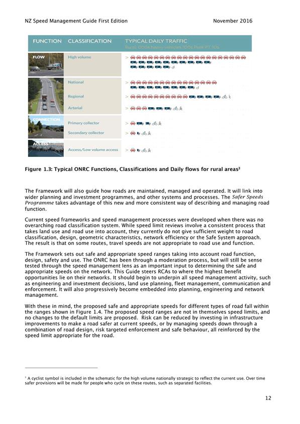
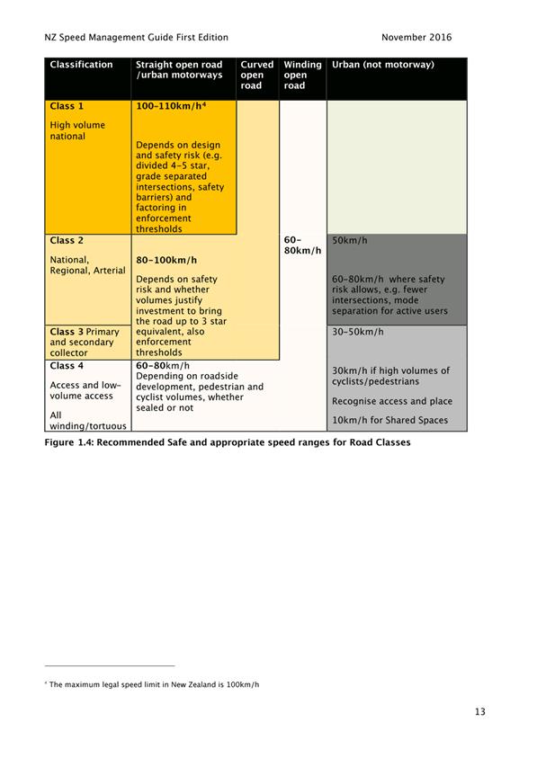
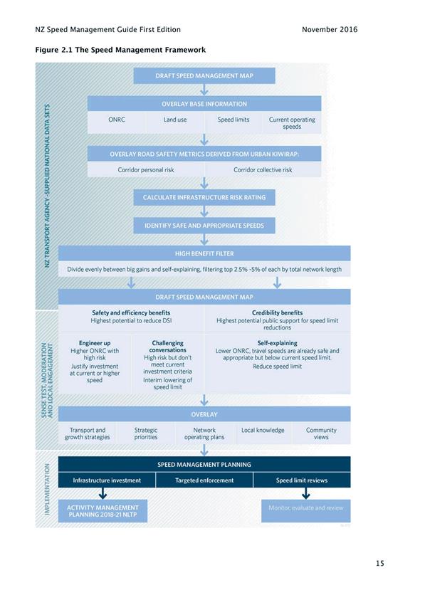
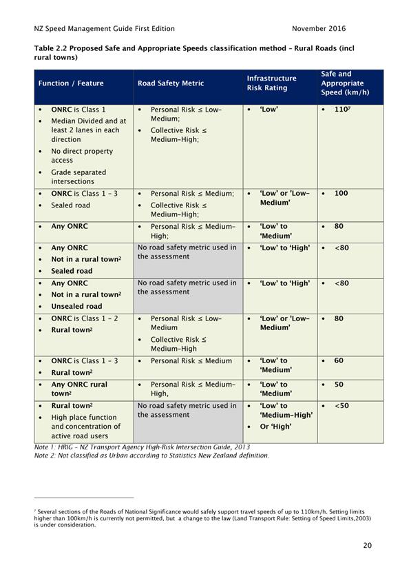
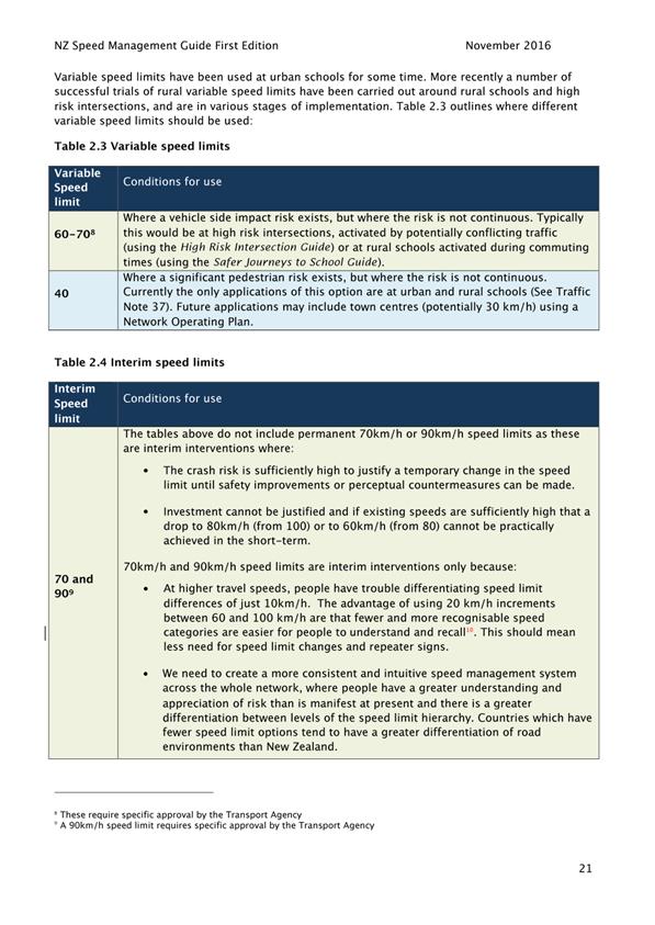
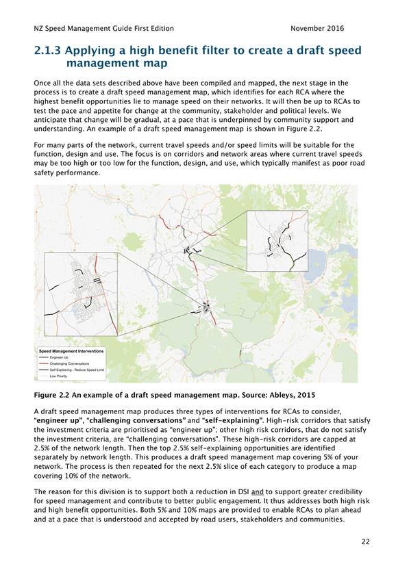
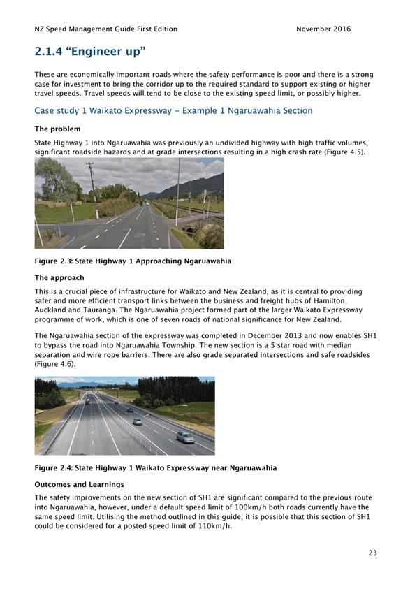
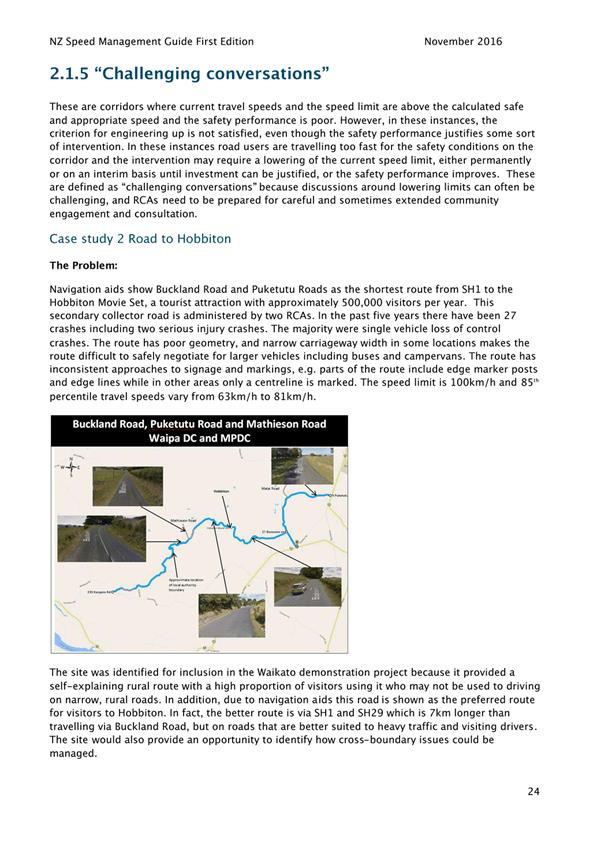
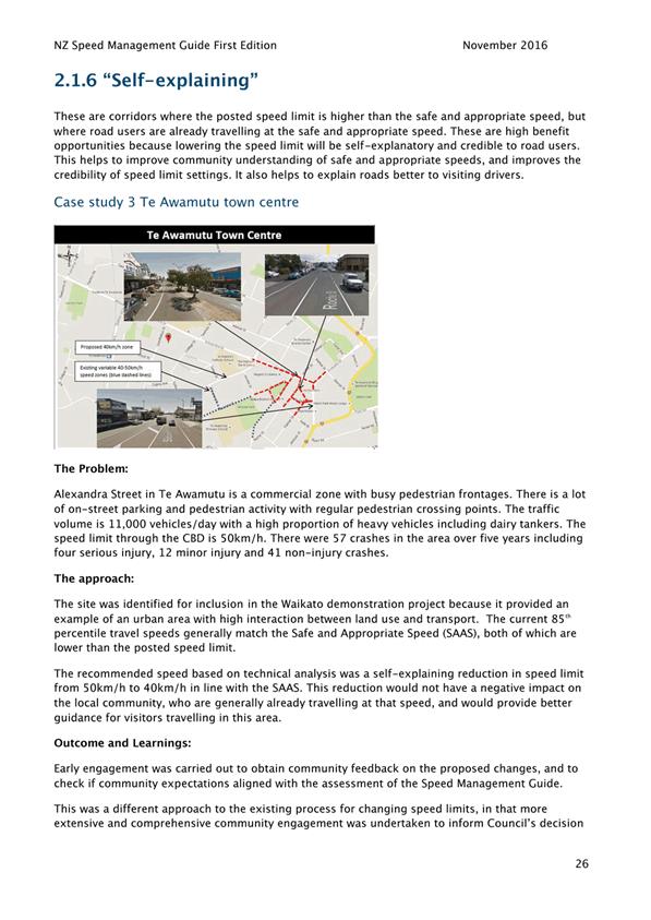
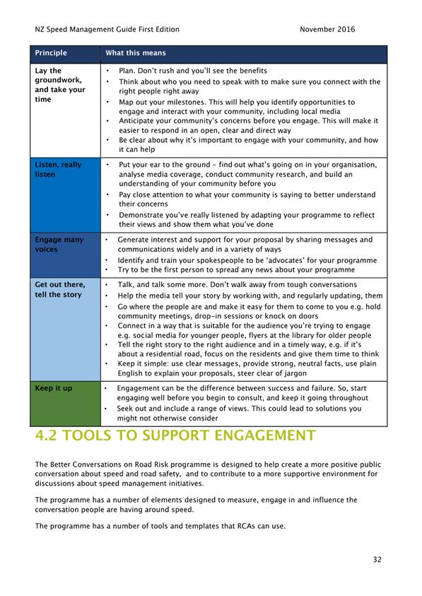
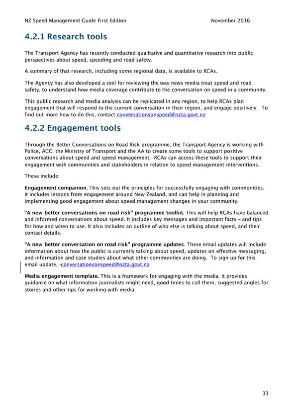
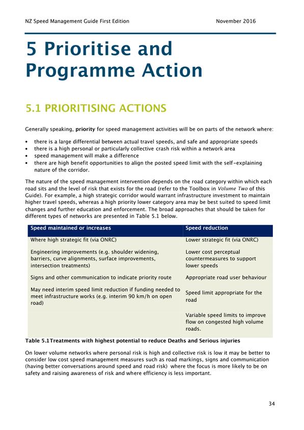
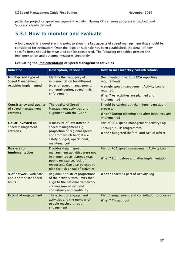
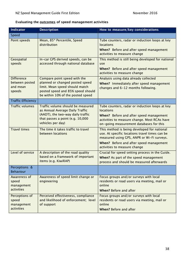
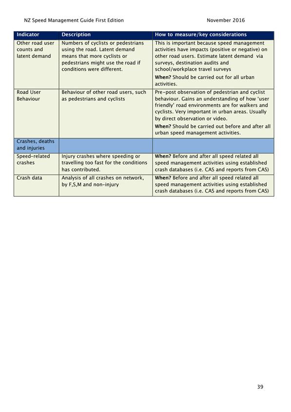
|
Infrastructure Services and Networks Committee
14 August 2017
|
|
Dunedin Urban Cycleways
Department: Transport
EXECUTIVE SUMMARY
1 The
purpose of this report is to seek approval to proceed with the Dunedin Urban
Cycleways preferred option for improvements within Dunedin’s central city
area.
2 Dunedin
City Council (DCC) was allocated $3 million in Urban Cycleway funding in 2015.
Projects using this fund must be substantially complete by 30 June 2018.
3 In August
2016, the Connecting Dunedin governance group agreed the scope of the Dunedin
Urban Cycleways programme for a project within the central city area. This
project is forecast to cost approximately $7 million. The balance of DCC urban
cycleway funding was reallocated by NZTA to the one way pair cycle project to
ensure Dunedin still received the benefit from this fund.
4 Community
consultation on concept designs for the Dunedin Urban Cycleways project was
undertaken in June 2017.
5 Feedback
received throughout the consultation period was generally in support of the
project. Staff have subsequently collated and summarised the feedback, which
has resulted in changes to some of the concept designs presented for
consultation.
6 It
is recommended that the Committee endorse the recommended option presented in
this report.
7 Following
Committee endorsement, staff will lodge a business case for the project with
the NZ Transport Agency for funding approval and approval to proceed to
implementation.
|
RECOMMENDATIONS
That the Committee:
a) Approves the
preferred option for the Dunedin Urban Cycleways project to be submitted to
the New Zealand Transport Agency for funding approval including new or
improved cycling infrastructure in the following areas:
i) Dunedin Railway Station to a new bridge over Water
of Leith near the mouth of the river, via Anzac Avenue, the St Andrew Street
carpark, and alongside the railway corridor and Wickcliffe Street
ii) The blocks between the State Highway One one-way
system (Duke, Howe, Dundas, Albany and Hanover Streets);
iii) A harbourside link along Fryatt, Birch and Kitchener
Streets, through Crosswharf Reserve between Fryatt and Birch Streets and the
full length of the existing shared path on Portsmouth Drive
b) Notes that
staff will review on-street car parking management in areas affected by
cycleways developments.
|
BACKGROUND
8 Dunedin’s
Strategic Cycle Network was adopted by the Council in 2011. The sum of $19.87
million is allocated for the Strategic Cycle Network in DCC’s current
Long Term Plan.
9 An
application was made to NZ Transport Agency’s Urban Cycleways Fund in
March 2015 to extend the cycleways infrastructure within Dunedin’s
central city area. The application was approved in August 2015, on the condition
that physical works are substantially completed by June 2018.
10 The Urban Cycleways
Programme and National Land Transport Programme (NLTP) fund are both
administered by the NZ Transport Agency. These funding mechanisms enable
up to two-thirds of cycleways funding to be met by the Government. The
remaining one-third is Dunedin’s local share.
11 In August 2016,
senior management from DCC, NZ Transport Agency, and Otago Regional Council
agreed a “Connecting Dunedin” governance group to oversee delivery
of Dunedin’s programme of transport projects.
12 The Connecting
Dunedin governance group agreed a revised scope for Dunedin’s Urban
Cycleways programme that focussed this project on connecting existing and
future infrastructure investment between the State Highway One (SH1) one-way
pair and around Dunedin’s harbour.
13 This project will
deliver approximately 5.0 km of safe and connected cycleways in central
Dunedin, a new bridge across the Water of Leith and supporting cycleways
infrastructure including wayfinding signage and cycle parking. The project has
a construction estimate of $6.1 million.
14 Construction of this
project must be completed by June 2018 to ensure Urban Cycleways funding is
received.
DISCUSSION
15 The Dunedin Urban Cycleways project for Dunedin’s
central city area aims to:
a) construct a
new cycleway from the Dunedin Railway Station to a new bridge over Water of
Leith near the mouth of the river via Anzac Avenue, the St Andrew Street
carpark, a new path alongside the railway corridor, and Wickcliffe Street;
b) improve the
safety of the road blocks between the SH1 one-way system (Duke, Howe, Dundas,
Albany, and Hanover Streets);
c) enhance
existing road markings and cycle lanes along Fryatt, Birch, and Kitchener
Streets, and widen the path along the harbour front between Fryatt and Birch
Streets;
d) build up and
resurface the existing Portsmouth Drive shared path.
16 Initial concept
designs for the Anzac Avenue, railway corridor extension, Water of Leith bridge,
and SH1 connectors were informed by the NZ Transport Agency’s cycle
network guidance. This is considered current best practice, and has been
developed with reference to the Christchurch City Council Major Cycleway Design
Guide, Auckland Transport Code of Practice, and Austroads design guidelines.
Stakeholder
Engagement
17 Initial concept
designs were presented to stakeholder representatives from SPOKES, the
Automobile Association, and NZ Transport Agency at a workshop in April
2017. These stakeholder groups have had experience with previous
Strategic Cycle Network implementation in Dunedin.
18 The purpose of the
workshop was to gain feedback on the initial concept designs and agree what
cycle facility types would be presented for wider community consultation.
19 Workshop
participants agreed that concept designs be prepared for community consultation
showing:
a) Anzac Avenue
– a 3.5m two-way cycleway on the south side with a separate footpath for
pedestrians, and replacing the on-road cycle lane on the north side with a
shoulder.
b) Rail Corridor
Extension – a 3m wide shared path with minor landscaping.
c) Water of Leith
Bridge – a 3.5m wide pedestrian/cycle bridge.
d) Duke and Howe
Streets – a shared road with sharrow markings and intersection thresholds.
e) Dundas Street
- green advance stop boxes.
f) Albany Street
- on-road cycle lanes with reflective lane dividers, and green advance stop
boxes at intersections.
g) Hanover Street
– a mid-block treatment that encourages reduced traffic speed, and green
advance stop boxes at intersection.
20 In addition, a
consultation concept plan was prepared for a harbourside link showing enhanced
road markings and cycle lanes along Fryatt, Birch, and Kitchener Streets, a
widened path through Crosswharf Reserve between Fryatt and Birch Streets and
highlighting the full length of the existing shared path on Portsmouth Drive to
be built up and resurfaced.
21 KiwiRail are a
specific stakeholder as a cycleway route is proposed to be built on their land.
KiwiRail gave Stage One in principle approval in August 2016. This signifies
acceptance of the route being constructed on the rail corridor with further
review required around specific elements of the design, for example separating
fence, clearances around Kiwirail equipment, and road rail interfaces.
Community
Consultation
22 Community
consultation was undertaken in June 2017.
23 A project
information flier was prepared and is included as Attachment A. This
information was uploaded on the Council’s website along with an overview
map, concept designs for each street and some artists impressions.
24 Project information
fliers were hand delivered to residential and business properties along the
proposed cycleway routes. An electronic copy of the flier was also emailed to
property owners and other parties identified as having an interest in the
Dunedin Urban Cycleways programme. The availability of project information was
also advertised via news and social media networks.
25 One-to-one meetings
were held with business and property owners as requested. Notes were taken
during these meetings, and business and property owners were also encouraged to
provide feedback through the on-line form.
26 A consultation
feedback summary is included as Attachment B. The summary was prepared by GHD consultants
who have been engaged as technical consultants to the Dunedin Urban Cycleways
project.
Summary
of Submissions
27 A total of 52
submissions were received during the consultation period. Of these submissions,
40 (77%) supported or generally supported the proposal, while 8 (15%) did
not.
28 The Automobile
Association, University of Otago, and Southern District Health Board provided
written submissions in support of the proposal.
29 The number and type
of submissions received are summarised in Figure 1 below.
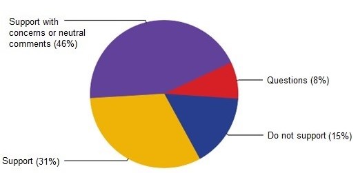
Figure 1 Summary of feedback – overall response
30 The main issues
raised through consultation feedback were:
· car parking (19 comments)
· safety of designs (17 comments)
· bicycle parking (13 comments)
· traffic calming for speed management (12 comments)
· traffic congestion (7 comments), and
· separation along shared paths (6 comments).
31 On-street car
parking was mentioned in 19 submissions. People who commented on car parking
mainly expressed concern with loss of on-street parking in Anzac Avenue and in
Albany Street.
32 The safety of the
designs was raised in seventeen (17) submissions. People who commented on
design aspects mainly expressed concern for the safety of cyclist and
pedestrians where they felt the concept designs did not take this into
account.
33 Specific issues
relating to Anzac Avenue, Albany Street and the harbour connection are
discussed below.
34 There were no
specific issues raised in relation to the railway corridor extension, new Water
of Leith bridge, Duke Street, Howe Street, Dundas Street, or Hanover Street
concept designs.
Anzac
Avenue
35 The main issues
raised in response to the Anzac Avenue concept design related to parking, the
safety of the designs and the need for traffic calming for speed
management.
36 The consultation
concept design proposed the loss of 14 4-hour pay and display car parks in
Anzac Avenue. This loss of parking was of particular concern to local
businesses and commercial tenants. Concerns about the proposed loss of
car parking was compounded by the new Cobb and Co restaurant, the potential
Cadbury World redevelopment, uncertainty over the future weekend use of the
Cadburys Bow Street car park for the Farmers Market and a lack of parking
circulation on week days caused by commuters parking all day.
37 A revised concept
design has been prepared in response to consultation feedback. The revised
design enables the existing on-street car parks to be retained, as well as the
creation of five new on-street car park spaces at the St Andrews Street end of
Anzac Avenue. Anzac Avenue is currently held under designation by the NZ
Transport Agency and this design requires approval from the NZ Transport Agency
prior to implementation.
38 The revised design
is achieved by narrowing the proposed cycle lane and removing the on-road
shoulder included on the consultation concept design. The revised design will
appear more constrained which will assist in reducing traffic speeds,
addressing concerns raised in some submissions. It also includes two
pedestrian crossing points to improve safety for people crossing the road to
and from the Farmers Market.
39 Should the revised
concept design not be approved by the NZ Transport Agency, staff recommend that
no works progress on Anzac Avenue at this time. Further discussions with NZTA
will be held to consider options for Anzac Avenue as part of a wider Railway
Station Precinct plan. Other comments received from business owners and
commercial tenants indicated that 2-hour pay and display on-street car parking
would better serve the area than the current 4-hour duration. There was also
suggestion to change traffic flow on Anzac Avenue to one-way only.
40 DCC is working with
NZ Transport Agency to improve conditions in the Railway Station Precinct
area. It is anticipated that car parking and vehicle circulation in the
area will be considered as part of a wider Railway Station Precinct plan.
Albany
Street
41 The main issues
raised in response to the Albany Street concept design related to the safety of
the designs and parking.
42 A tour coach/bus
stop is needed to be retained in Albany Street alongside Museum Reserve.
The consultation concept design proposed cycle lanes with reflective lane
dividers which a bus would cross to enter the bus stop. Cyclists would ride
along the outside of a waiting bus, between the bus and the vehicle lane. The
safety of this design was also raised in a safety audit.
43 A revised concept
design has been prepared in response to consultation feedback and the safety
audit. In the revised design cyclists would ride along the inside of a
waiting bus, between the bus and the footpath. This design is currently used in
Christchurch and was put forward as an option by the safety audit team. A
picture showing this design in use in Christchurch in included as Attachment C.
44 In addition, the
consultation design proposed the loss of six 4-hour pay and display car parking
space on Albany Street. This loss of parking is of particular concern to the
Otago Museum, as it is on top of car parking loss proposed by the SH1 one way
pair cycle lanes project.
45 Staff discussed
opportunities to improve parking management in the area with the Museum.
Metered parking is currently located on both sides of Cumberland Street between
Albany Street and St David Street, and for the full block of Union Street
between Cumberland Street and Castle Street. In contrast, on-street parking is
unrestricted in the parallel block on Castle Street and unrestricted in St
David Street. St David Street is 400 metres from the Museum main entrance
and a safe walk from the Museum, as no main roads need to be crossed.
46 The Museum
encouraged the Council to improve parking management in the area, and indicated
that changing parking in St David Street to 4-hour pay and display would help
mitigate the loss of 4-hour pay and display on-street parking in the area as a
result of cycleways development. Staff will follow up this request as part of
St David Street improvements being made in conjunction with the SH1 Cycleway
project.
Harbour
connections
47 The main issues
raised in response to the harbour connection concept design related to the
safety of designs and separation between pedestrians and cyclists within
Crosswharf Reserve between Fryatt Street and Birch Street.
48 The key issue within
Crosswharf Reserve relates to older people and disabled people who are using
this area being at risk of injury resulting from collisions between pedestrians
and cyclists. The consultation concept design proposed to widen the
current shared path along the upper section of Crosswharf Reserve from 2.5m to
3.2m and set street furniture back.
49 It is proposed to
manage these concerns by signposting the lower section of Crosswharf Reserve
‘No Cycling’. The lower section can be accessed by stairs and ramps
at both ends. The upper shared path section will be signed with courtesy signs
reminding users to share the path.
50 In addition, there
are a number of locations where cyclists will cross the road and pass busy
vehicle entrances such as off-road car parks. Signage will be added to alert
cyclists and motorists to potential conflict areas.
Portsmouth
Drive
51 The main issues
raised in response to the Portsmouth Drive concept design related to the separation
between cyclist and vehicles along Portsmouth Drive.
52 The current shared
path is separated from the vehicle lanes for the majority of the length by a
landscape strip. However, from Orari Street to Strathallan Street there is no
landscape strip and path users are at the same height as the road because
drainage is provided by a dish channel.
53 It is proposed to
manage these concerns by installing new kerb and channel along this section of
Portsmouth Drive. This will provide grade separation by elevating path users
above the vehicle lanes, in a similar way to a footpath.
Supporting
Infrastructure
54 NZ
Transport Agency’s Urban Cycleways Programme fund extends to supporting
cycleway infrastructure including wayfinding signage and cycle parking.
55 Appropriate
directional and wayfinding information for cyclists will be installed as part
of this project, and include signage to existing cycle routes completed in
previous years. A comprehensive signs and markings plan will be prepared to
ensure consistent guidance is given to all road users where changes are
proposed.
56 Comments
were received in 13 submissions about where the Council should put bicycle
parking. The locations for new cycle parking and the style of
the infrastructure will be agreed with DCC’s urban design team and
installed as part of this project. Directional
signage will direct cyclists to cycle parking locations.
Preferred
Option Concept Designs
57 Changes to some
consultation concept plans have occurred following review of the submissions
received and following subsequent feedback received from stakeholders. Concept
designs have been prepared for a project preferred option showing:
a) Anzac Avenue (design
change) - a 3m two-way cycleway on the south side with a separate footpath for
pedestrians, and car parking on both sides of the road (subject to NZ Transport
Agency approval), included as Attachment D.
b) Rail Corridor
Extension (no change) – a 3m wide shared path with minor landscaping,
included as Attachment E.
c) Water of Leith
Bridge (no change) – a 3.5m wide pedestrian/cycle bridge, included as
Attachment F.
d) Duke and Howe
Streets (no change) – a shared road with sharrow markings and
intersection thresholds, included as Attachment G and H.
e) Dundas Street
(no change) - green advance stop boxes with cycle approach lanes, included as
Attachment I.
f) Albany Street
(design change) - on-road cycle lanes with reflective lane dividers and green
advance stop boxes at intersections. Cycle bypass path inside bus stop with
raised treatment to slow cyclists and bus passenger zone for passenger safety, included
as Attachment J.
g) Hanover Street
(no change) – a mid-block treatment that encourages reduced traffic
speed, and green advance stop boxes at intersection, included as Attachment K.
h) A harbourside
link with enhanced road markings and cycle lanes along Fryatt, Birch, and
Kitchener Streets, a 3.2m wide path through Crosswharf Reserve between Fryatt
and Birch Streets and the full length of the existing shared path on Portsmouth
Drive that will be built up and resurfaced, included as Attachment L and M.
OPTIONS
58 Three options are
put forward for consideration.
Option
One – Recommended Option
59 The Committee
approves the project preferred option to be submitted to NZ Transport Agency
for funding approval which includes:
a) Dunedin
Railway Station to a new bridge over Water of Leith near the mouth of the river
via Anzac Avenue, the St Andrew Street carpark, alongside the railway corridor,
and Wickcliffe Street;
b) The blocks
between the SH1 one-way system (Duke, Howe, Dundas, Albany, and Hanover
Streets);
c) A harbourside
link along Fryatt, Birch, and Kitchener Streets, through Crosswharf Reserve
between Fryatt and Birch Streets and the full length of the existing shared
path on Portsmouth Drive
Advantages
· Enables
timely submission of a Business Case to the New Zealand Transport Agency for
funding approval to proceed to implementation.
· Likely
to result in Dunedin benefiting from Urban Cycleways Programme funding which
sees two thirds of project costs being met by the New Zealand Transport Agency.
· Responds
to consultation feedback in support of Dunedin Urban Cycleways.
· Establishes
safe cycle connections between the SH1 one way pair cycle lanes and completes the
inner harbour section of a harbour circuit.
Disadvantages
· Will
result in changes to the existing road network which may disadvantage some road
users.
· The
proposed programme does not make use of all of the urban cycleway funding
available to DCC.
Option
Two – Recommended Option with changes
60 The Committee
approves the project preferred option with changes to be submitted to NZ
Transport Agency for approval.
Advantages
· Likely
to result in Dunedin benefiting from Urban Cycleways Programme funding which
sees two thirds of project costs being met by the New Zealand Transport Agency.
· Will
provide an increased level of service for cyclists in Dunedin.
Disadvantages
· Delays
submission of a Business Case to New Zealand Transport Agency for funding approval
to proceed to implementation.
· May
present a risk to the project budget if changes result in a higher construction
estimate.
· May
present a risk to the project timetable if changes cannot be constructed by 30
June 2018.
· Likely
to result in changes to the existing road network which may disadvantage some
road users.
Option
Three – Status Quo
61 The Committee does
not approve any option.
Advantages
· Will
retain the existing level of service for road users with no changes to the road
network.
· Council
will not need to spend its local share.
· No
risk to Council of not completing construction by 30 June 2018.
Disadvantages
· Does
not result in Council benefitting from Urban Cycleways Programme funding.
· Does
not respond to consultation feedback in support of Dunedin Urban Cycleways.
· Unlikely
to improve road safety for cyclists in Dunedin.
NEXT STEPS
62 Subject to approval
of a preferred option by the Committee, staff will submit a Business Case to
the New Zealand Transport Agency for funding approval to proceed to
implementation.
63 On receipt of this
approval, construction contracts will be tendered for construction to commence
in December 2017.
Signatories
|
Author:
|
Susan Lilley - Senior Transportation Planner
|
|
Authoriser:
|
Richard Saunders - Group Manager Transport
Ruth Stokes - General Manager Infrastructure and
Networks
|
Attachments
|
|
Title
|
Page
|
|
a
|
Dunedin Urban Cycleways
project flier
|
253
|
|
b
|
Consultation Feedback
Summary
|
255
|
|
c
|
Bus stop design used in
Christchurch
|
265
|
|
d
|
Anzac Avenue project
preferred option
|
266
|
|
e
|
Railway Corridor
Extension project preferred option
|
268
|
|
f
|
Water of Leith bridge
project preferred option
|
274
|
|
g
|
Duke Street project
preferred option
|
275
|
|
h
|
Howe Street project preferred
option
|
276
|
|
i
|
Dundas Street project
preferred option
|
277
|
|
j
|
Albany Street project
preferred option
|
279
|
|
k
|
Hanover Street project
preferred option
|
280
|
|
l
|
Harbourside link
project preferred option
|
281
|
|
m
|
Portsmouth Drive
project preferred option
|
298
|
|
SUMMARY OF CONSIDERATIONS
|
|
Fit with purpose
of Local Government
This report relates to providing local infrastructure and
it is considered good-quality and cost-effective.
|
|
Fit with strategic
framework
|
|
Contributes
|
Detracts
|
Not applicable
|
|
Social Wellbeing Strategy
|
☒
|
☐
|
☐
|
|
Economic Development Strategy
|
☒
|
☐
|
☐
|
|
Environment Strategy
|
☒
|
☐
|
☐
|
|
Arts and Culture Strategy
|
☐
|
☐
|
☒
|
|
3 Waters Strategy
|
☐
|
☐
|
☒
|
|
Spatial Plan
|
☒
|
☐
|
☐
|
|
Integrated Transport Strategy
|
☒
|
☐
|
☐
|
|
Parks and Recreation Strategy
|
☒
|
☐
|
☐
|
|
Other strategic projects/policies/plans
|
☐
|
☐
|
☒
|
Dunedin Urban Cycleways delivers on the
Integrated Transport Strategy focus on safety and focus on travel
choices.
|
|
Māori Impact
Statement
Staff consulted with KTKO in relation to
a new Water of Leith bridge and any potential impact to the river. The
advice was that there were no major concerns for Te Rūnanga o
Otakou. There are no other known impacts.
|
|
Sustainability
Making cycling safer and more attractive can contribute to
sustainability.
|
|
LTP/Annual Plan /
Financial Strategy /Infrastructure Strategy
The project is included in the Long Term Plan.
|
|
Financial
considerations
Any costs associated with Dunedin Urban
Cycleways have been met from existing budgets.
|
|
Significance
This decision is considered to be of low
significance under the Significance and Engagement Policy.
|
|
Engagement –
external
Staff have engaged with a number of key
stakeholders during the development of the Dunedin Urban Cycleways project.
This includes SPOKES, the Automobile Association, NZ Transport Agency, the Otago Regional Council and University
of Otago. There has been support for the project from these stakeholders.
|
|
Engagement -
internal
Feedback has been sought from Parks and
Recreation and City Development (Urban Design).
|
|
Risks: Legal /
Health and Safety etc.
If the project is not delivered by 30 June 2018, Urban
Cycleways Programme funding may not be provided. There are no other
known risks.
|
|
Conflict of
Interest
There are no conflicts of interest.
|
|
Community Boards
This project is not in a Community Board area. The
harbour connection, including the Water of Leith Bridge, will connect to
planned and future cycleways projects that are strongly supported by the West
Harbour Community Board and the Otago Peninsula Community Board.
|
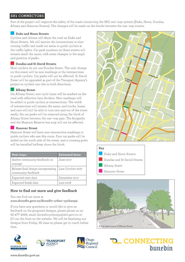
|
Infrastructure Services and Networks Committee
14 August 2017
|
|
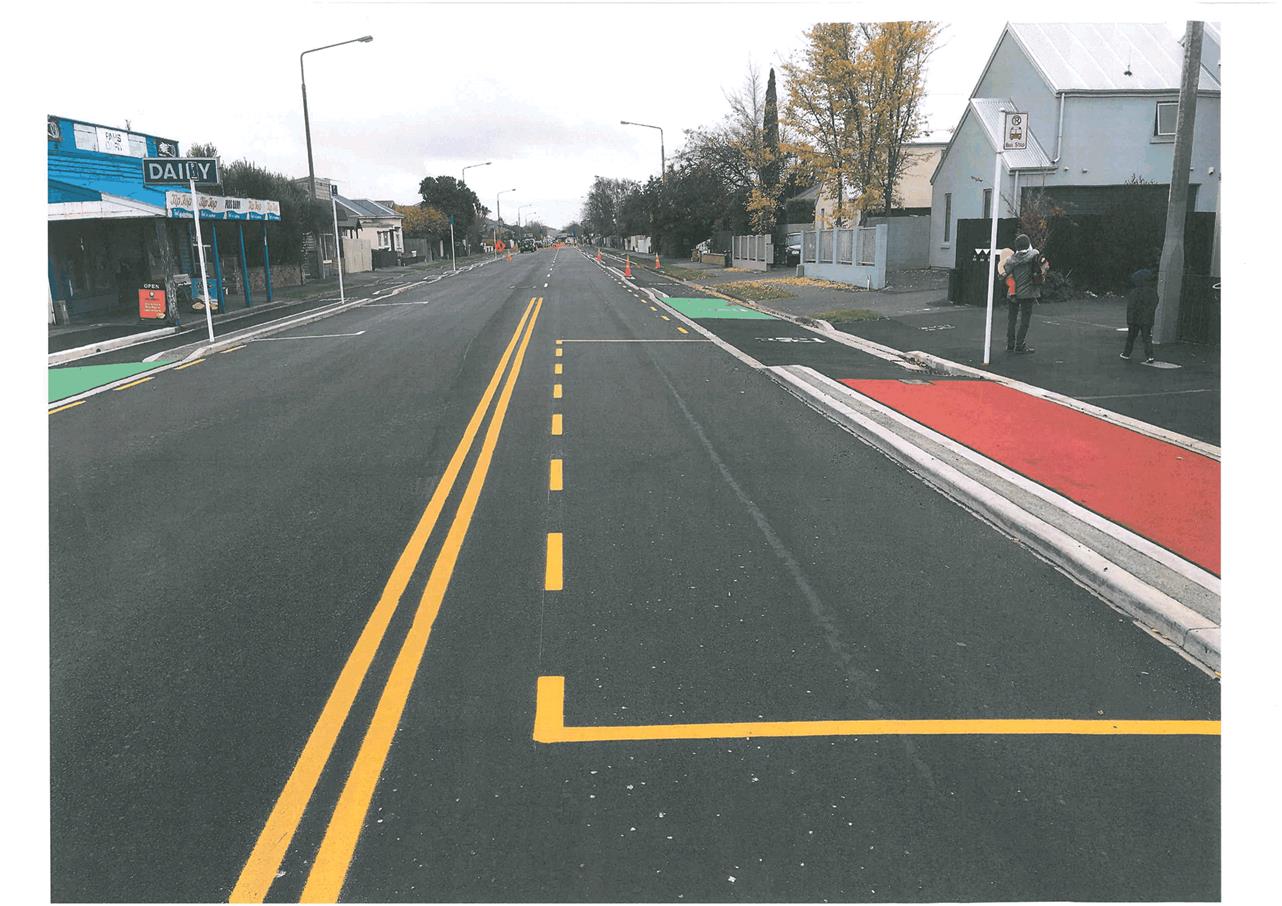
|
Infrastructure Services and Networks Committee
14 August 2017
|
|
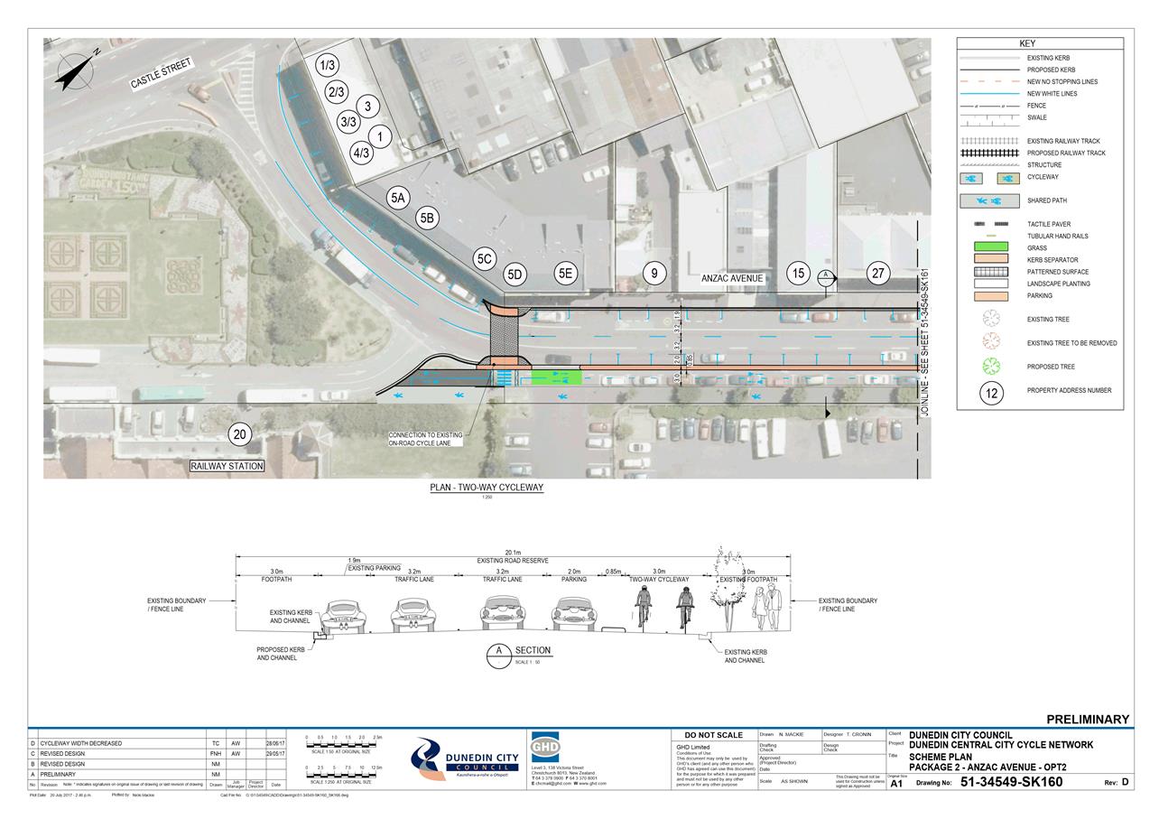
|
Infrastructure Services and
Networks Committee
14 August 2017
|
|
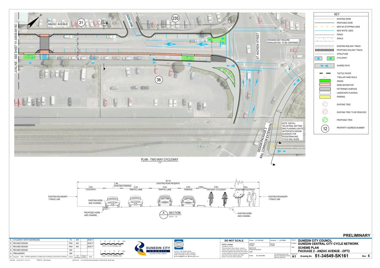
|
Infrastructure Services and
Networks Committee
14 August 2017
|
|
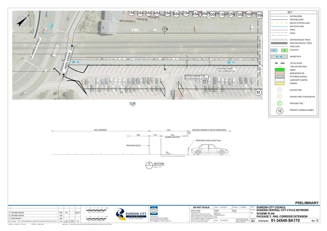
|
Infrastructure Services and
Networks Committee
14 August 2017
|
|
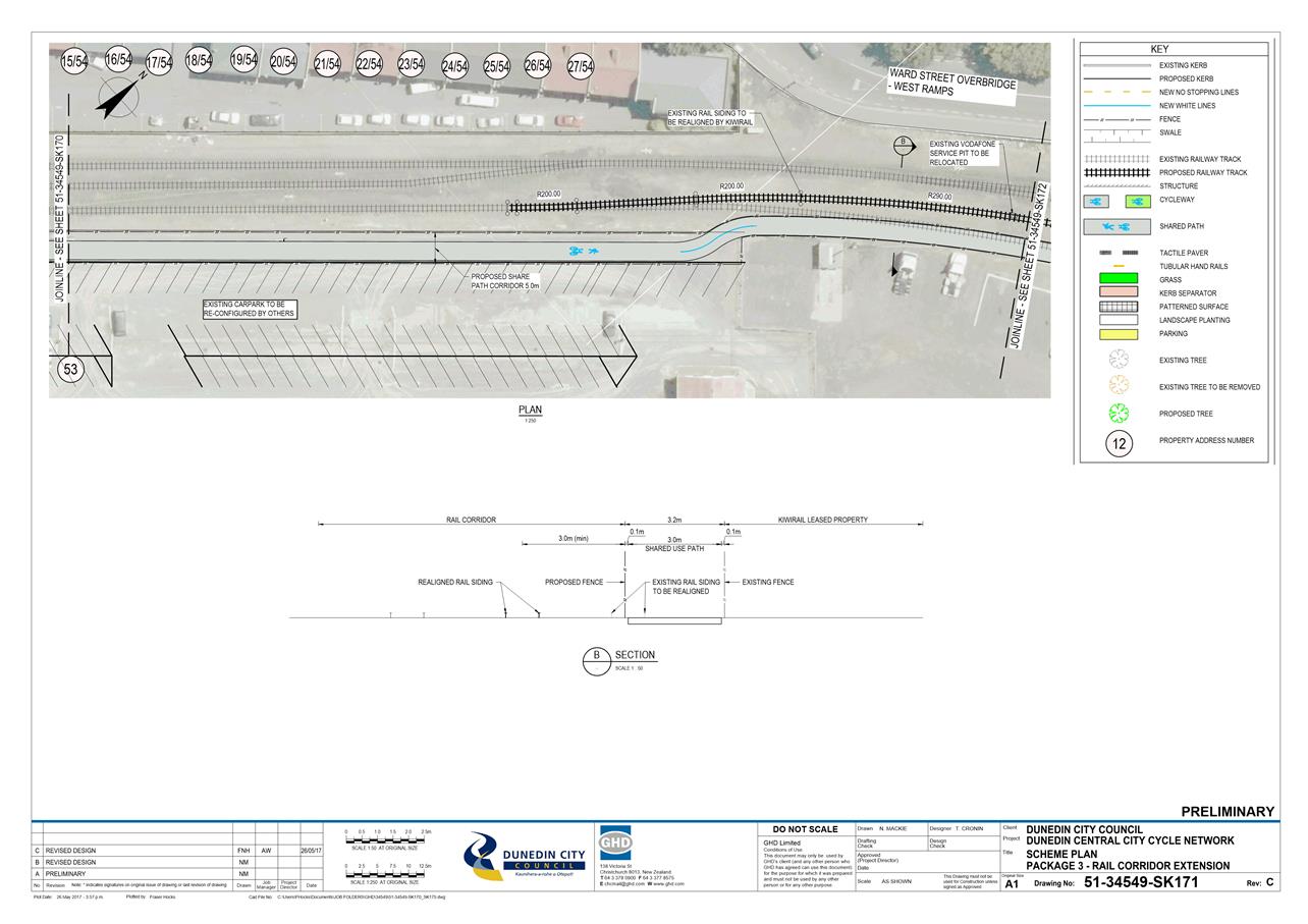
|
Infrastructure Services and
Networks Committee
14 August 2017
|
|
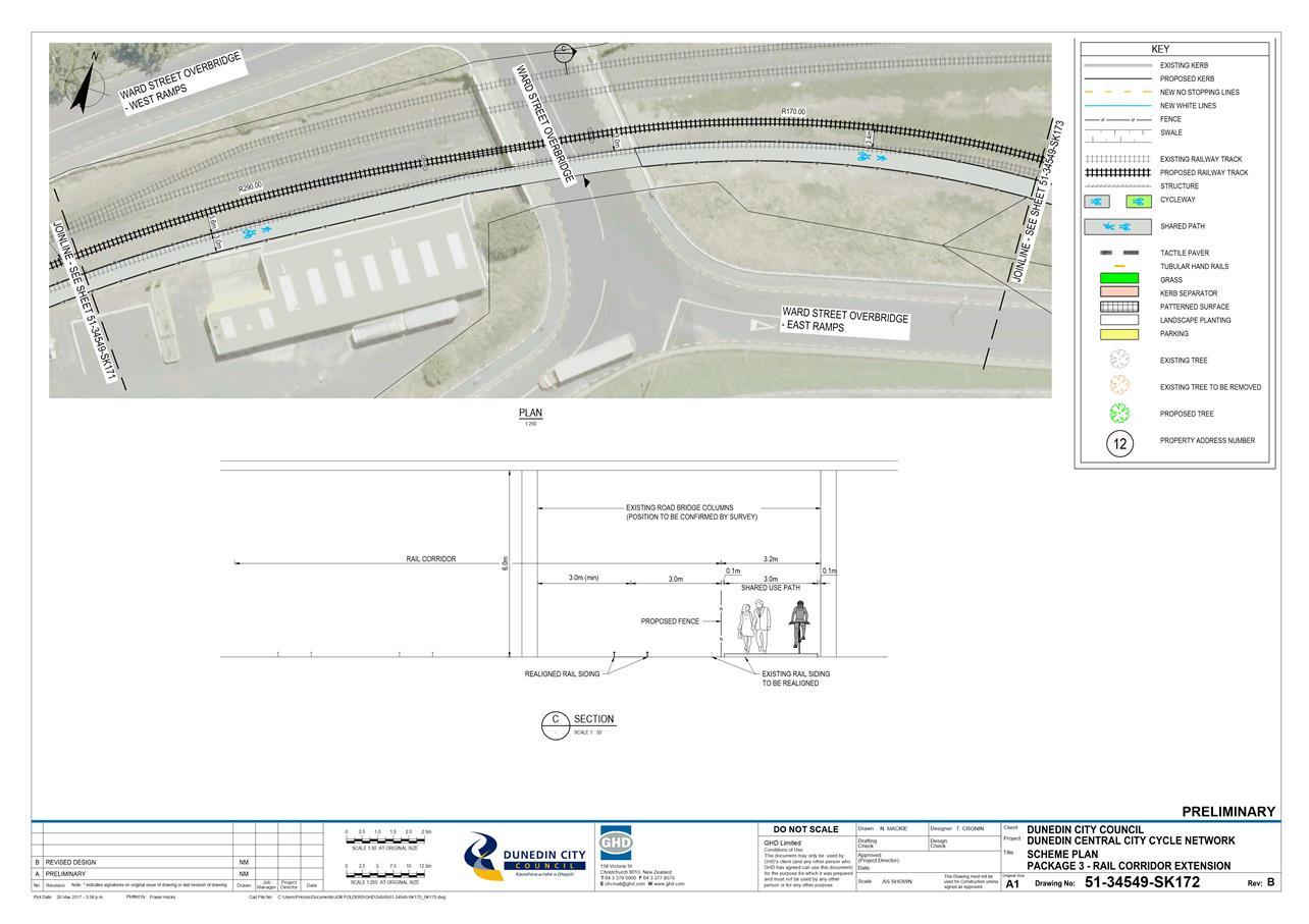
|
Infrastructure Services and
Networks Committee
14 August 2017
|
|
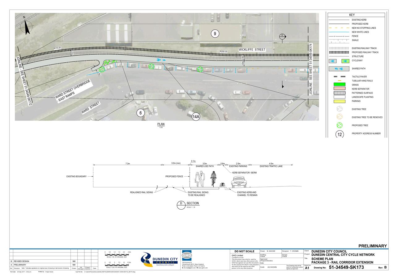
|
Infrastructure Services and
Networks Committee
14 August 2017
|
|
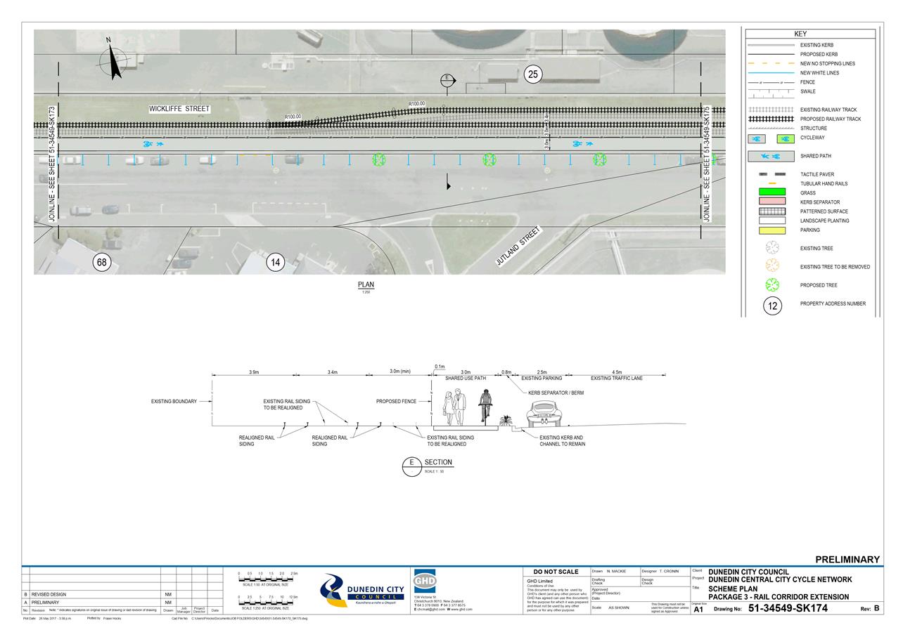
|
Infrastructure Services and
Networks Committee
14 August 2017
|
|
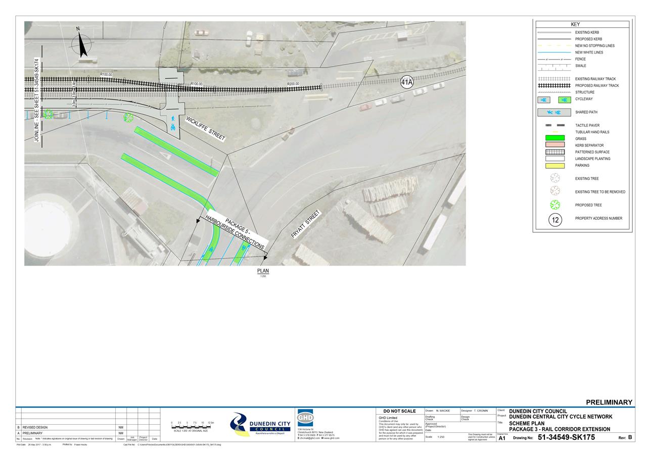
|
Infrastructure Services and
Networks Committee
14 August 2017
|
|
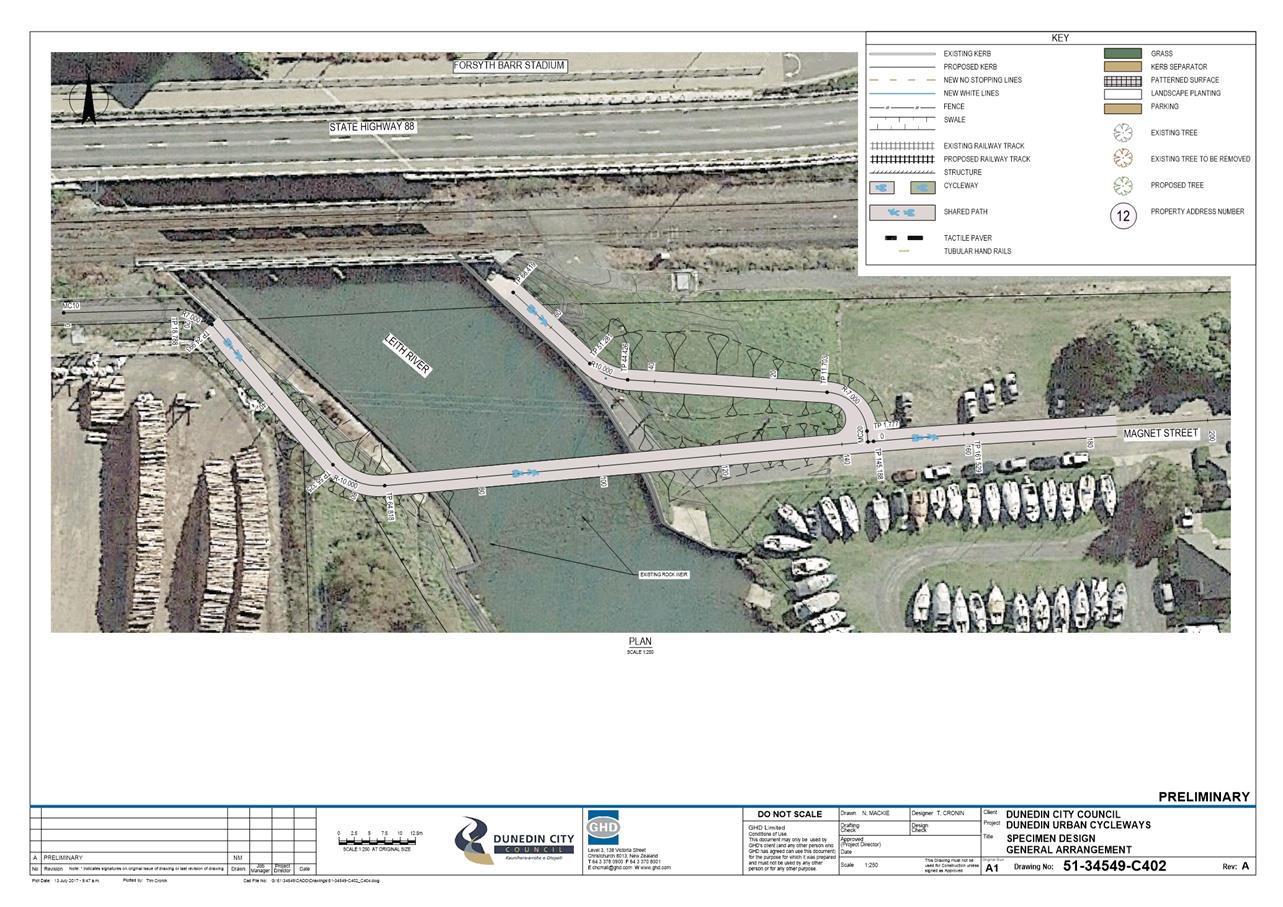
|
Infrastructure Services and Networks Committee
14 August 2017
|
|
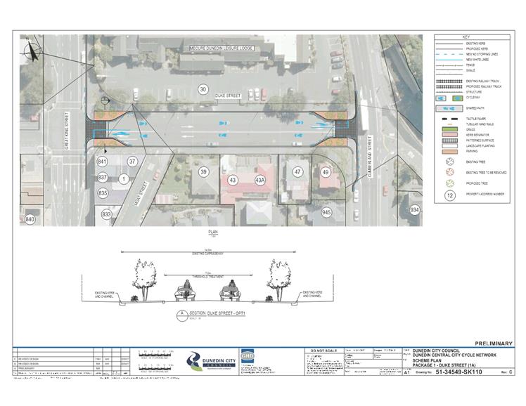
|
Infrastructure Services and Networks Committee
14 August 2017
|
|
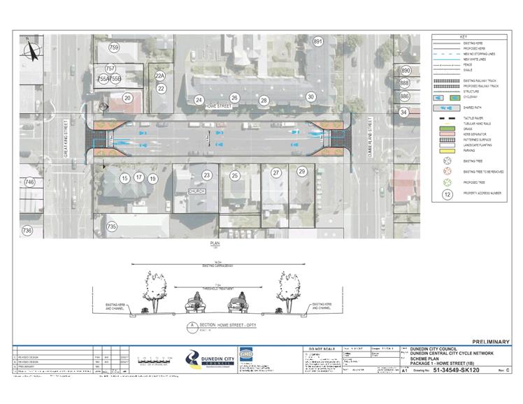
|
Infrastructure Services and Networks Committee
14 August 2017
|
|
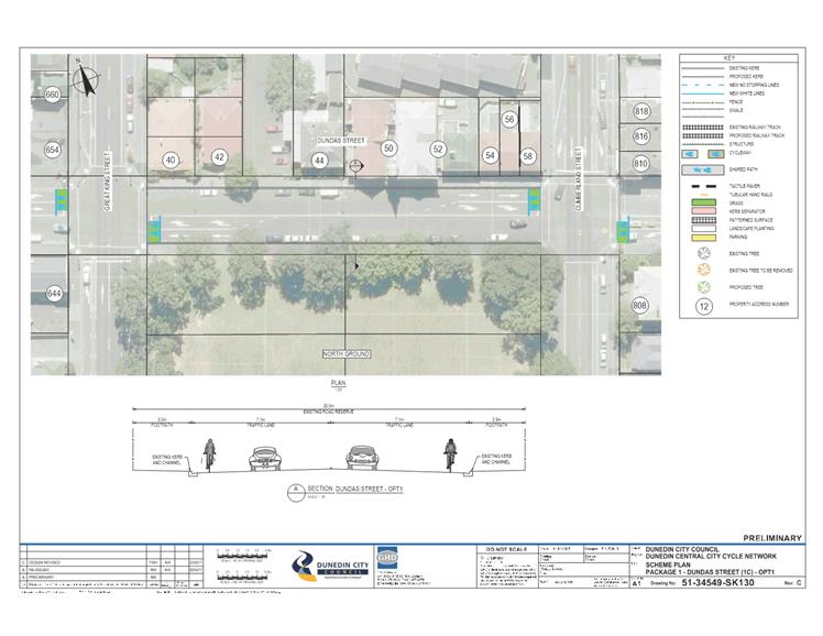
|
Infrastructure Services and Networks Committee
14 August 2017
|
|
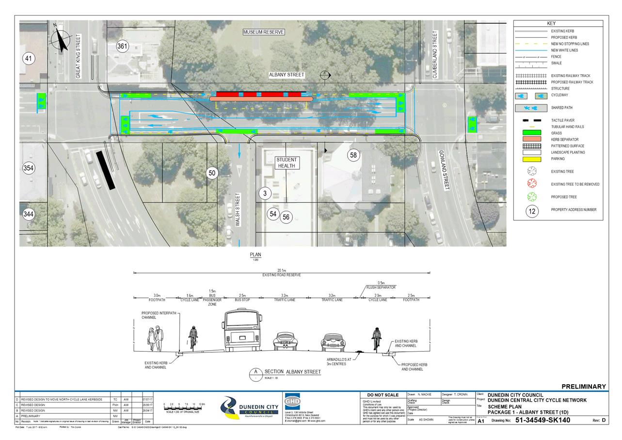
|
Infrastructure Services and Networks Committee
14 August 2017
|
|
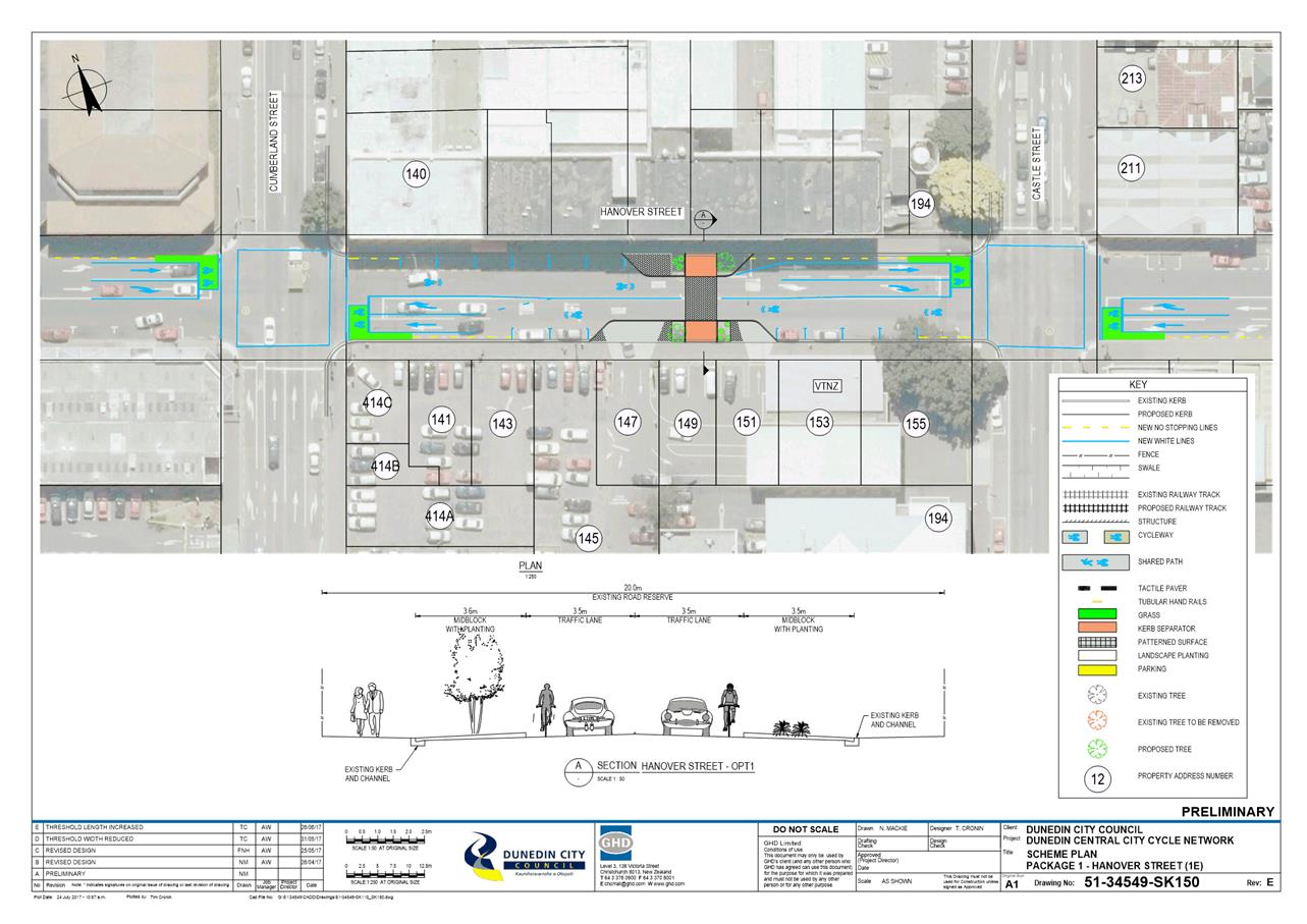
|
Infrastructure Services and Networks Committee
14 August 2017
|
|
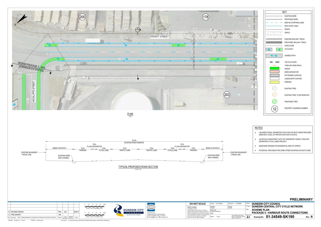
|
Infrastructure Services and
Networks Committee
14 August 2017
|
|
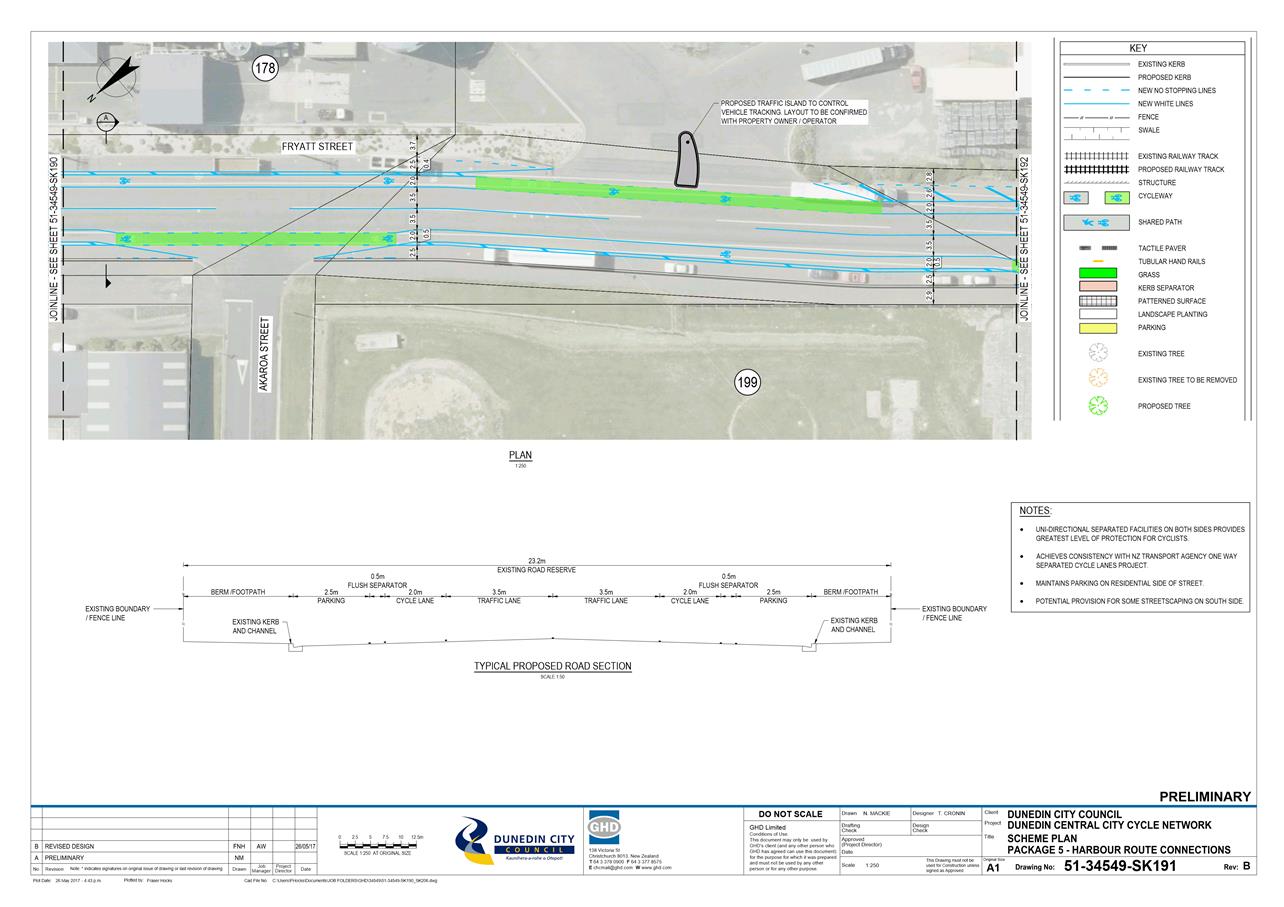
|
Infrastructure Services and
Networks Committee
14 August 2017
|
|
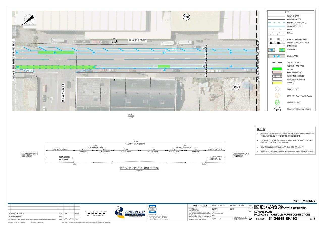
|
Infrastructure Services and
Networks Committee
14 August 2017
|
|
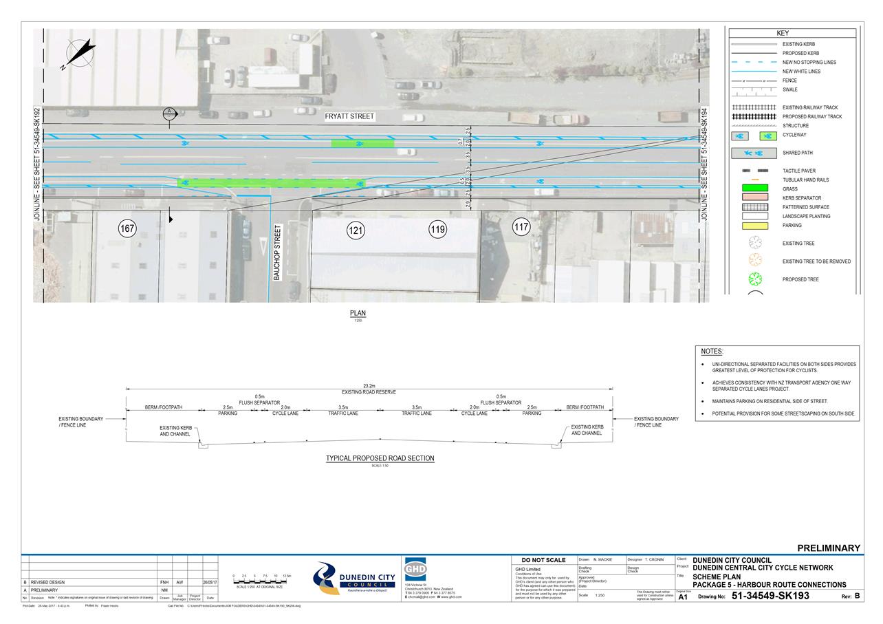
|
Infrastructure Services and
Networks Committee
14 August 2017
|
|
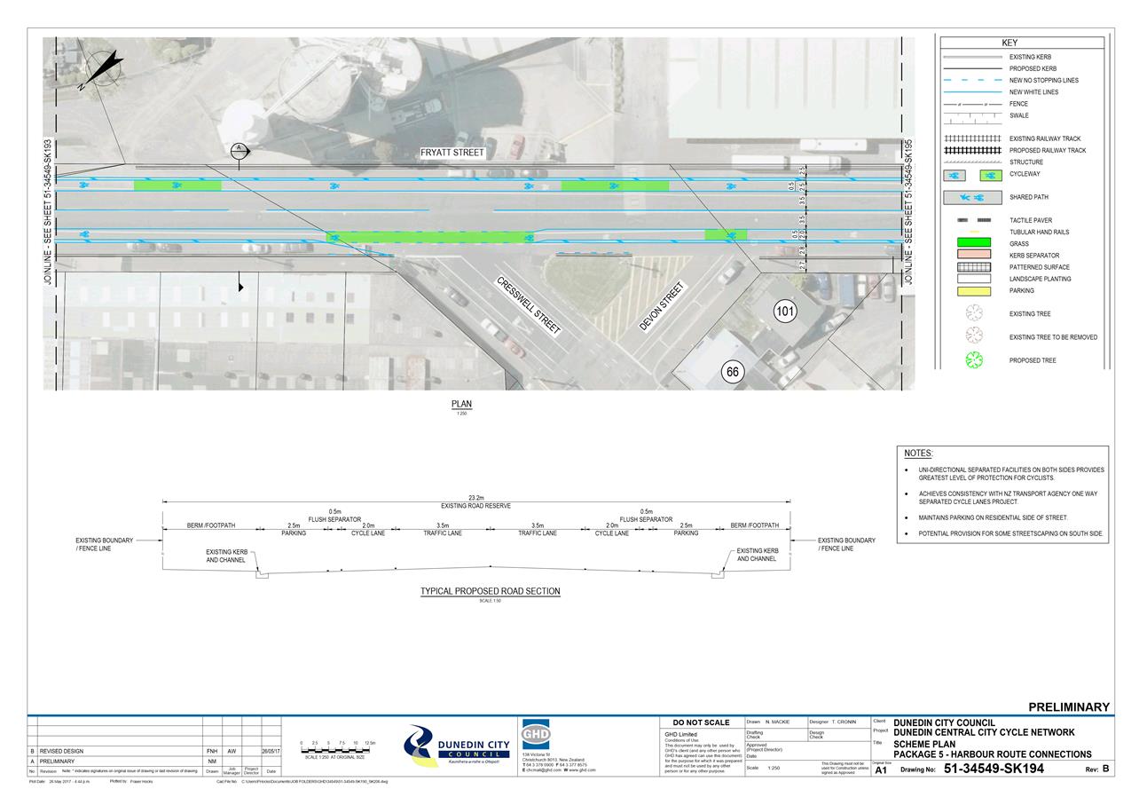
|
Infrastructure Services and
Networks Committee
14 August 2017
|
|
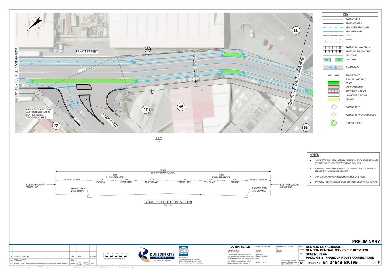
|
Infrastructure Services and
Networks Committee
14 August 2017
|
|
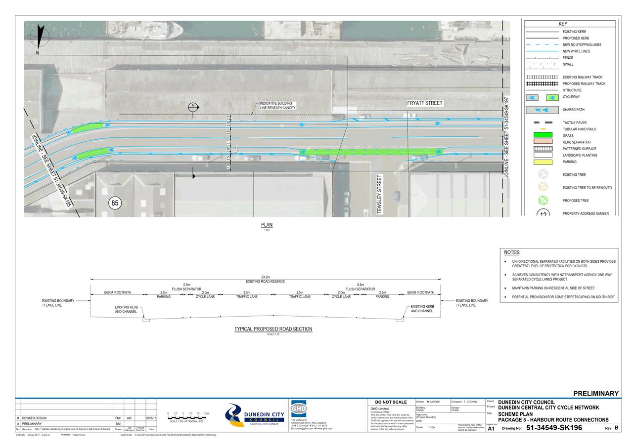
|
Infrastructure Services and
Networks Committee
14 August 2017
|
|
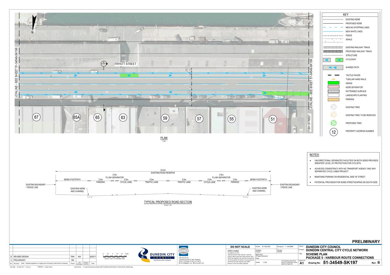
|
Infrastructure Services and
Networks Committee
14 August 2017
|
|
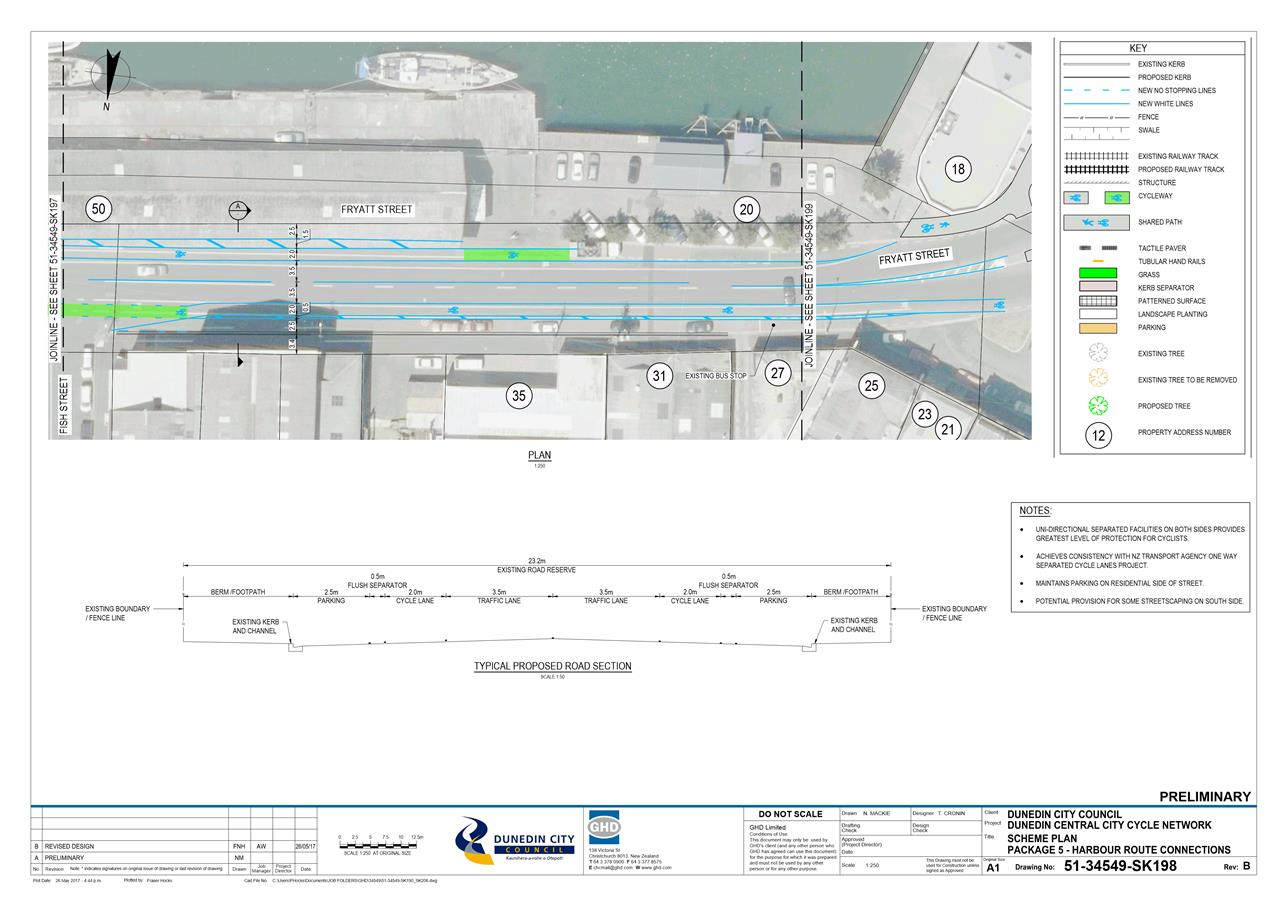
|
Infrastructure Services and
Networks Committee
14 August 2017
|
|
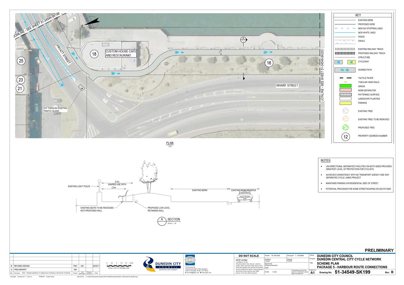
|
Infrastructure Services and
Networks Committee
14 August 2017
|
|
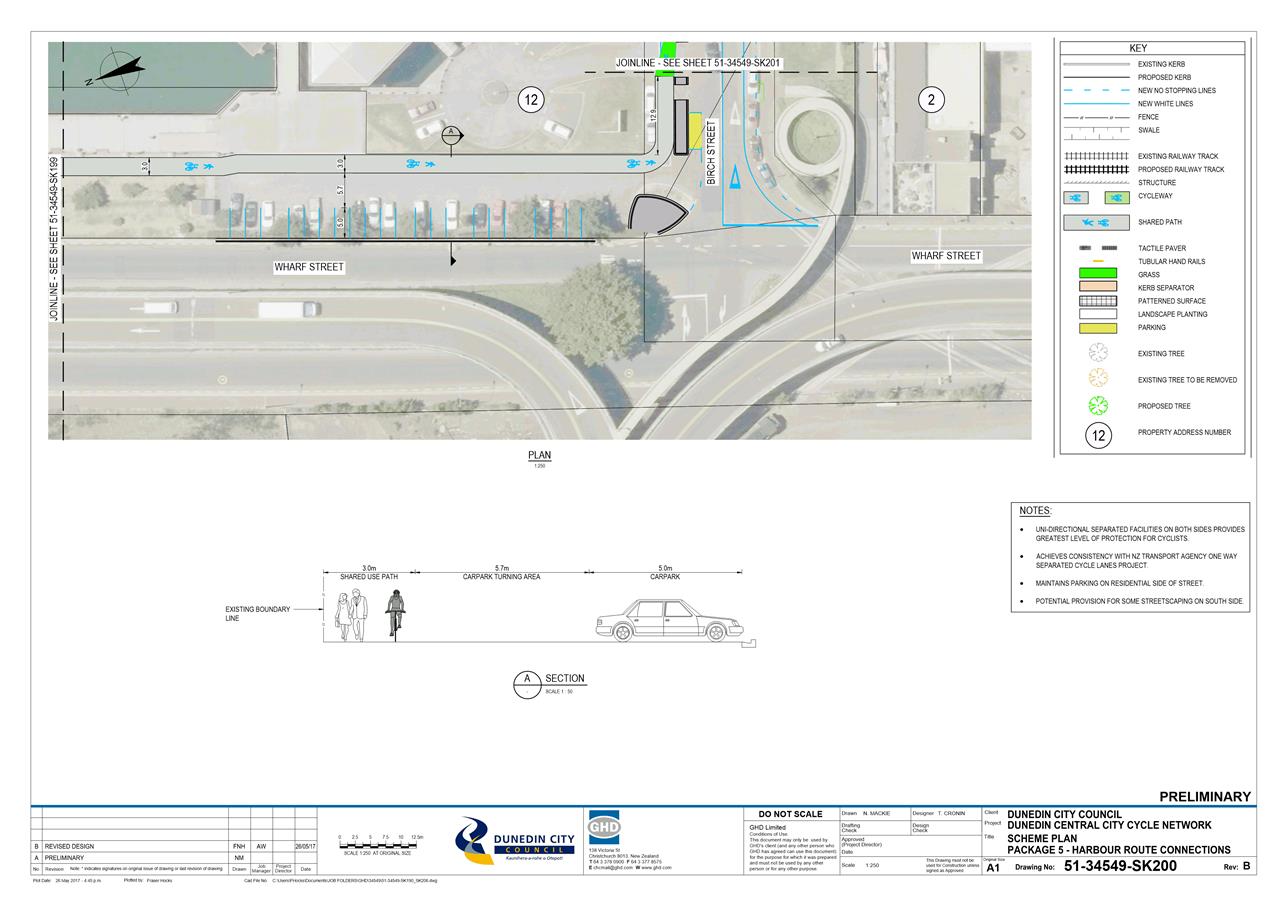
|
Infrastructure Services and
Networks Committee
14 August 2017
|
|
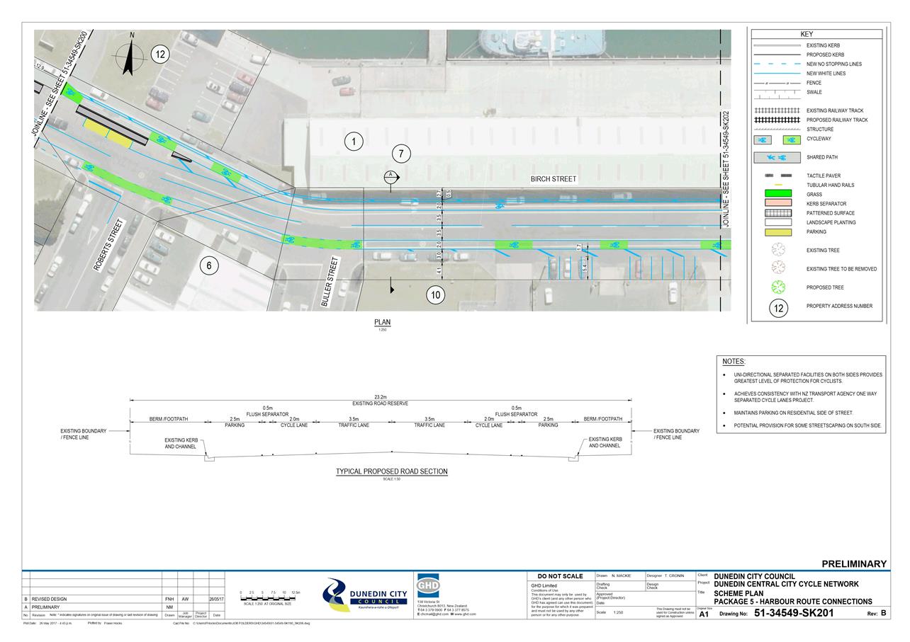
|
Infrastructure Services and
Networks Committee
14 August 2017
|
|
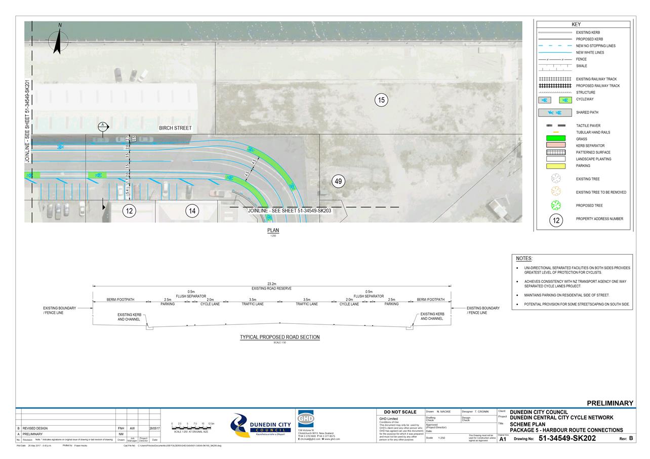
|
Infrastructure Services and
Networks Committee
14 August 2017
|
|
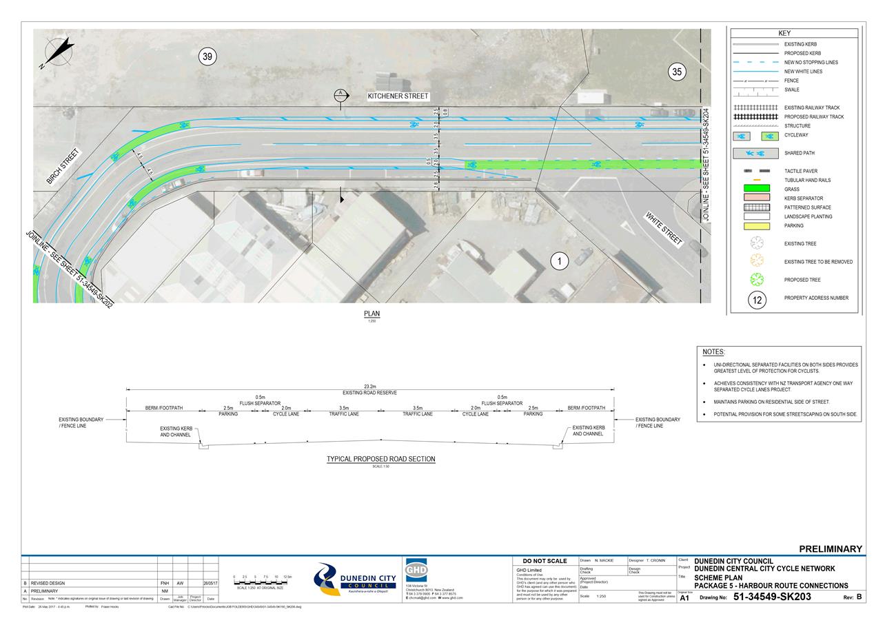
|
Infrastructure Services and
Networks Committee
14 August 2017
|
|
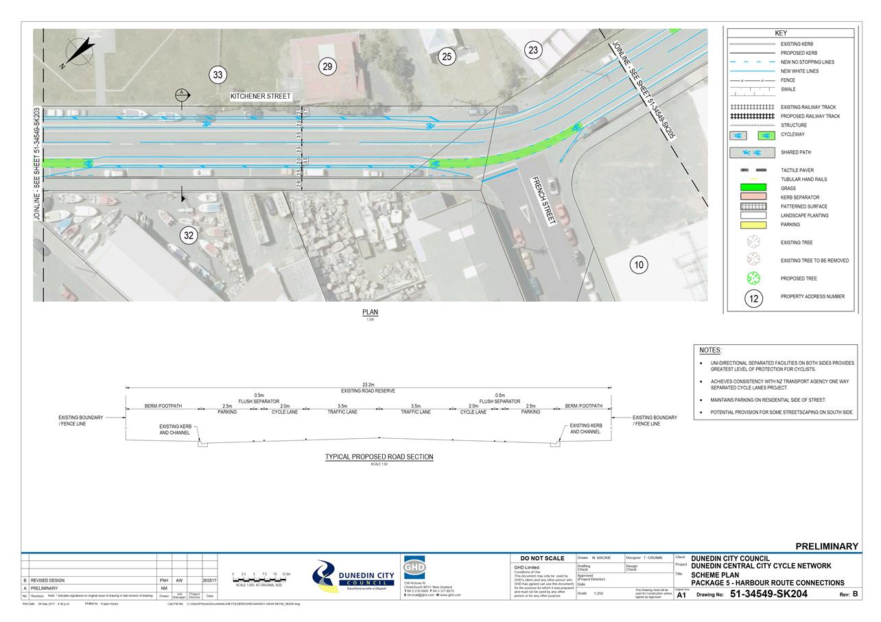
|
Infrastructure Services and
Networks Committee
14 August 2017
|
|
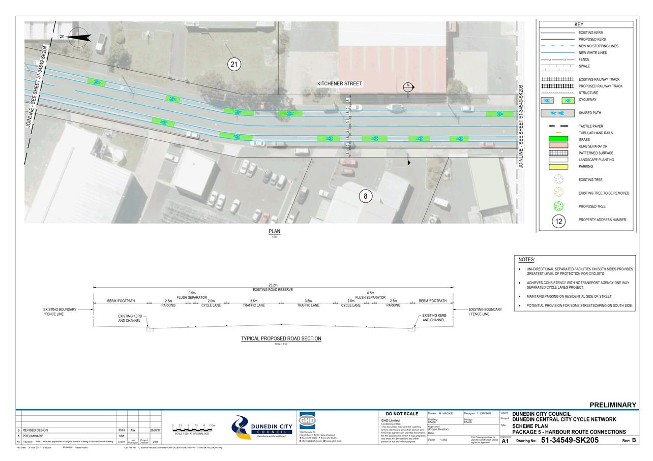
|
Infrastructure Services and
Networks Committee
14 August 2017
|
|
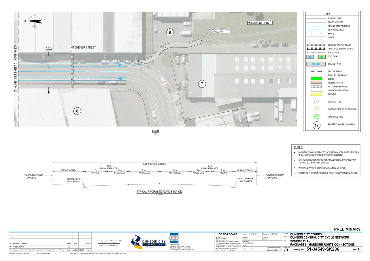
|
Infrastructure Services and
Networks Committee
14 August 2017
|
|
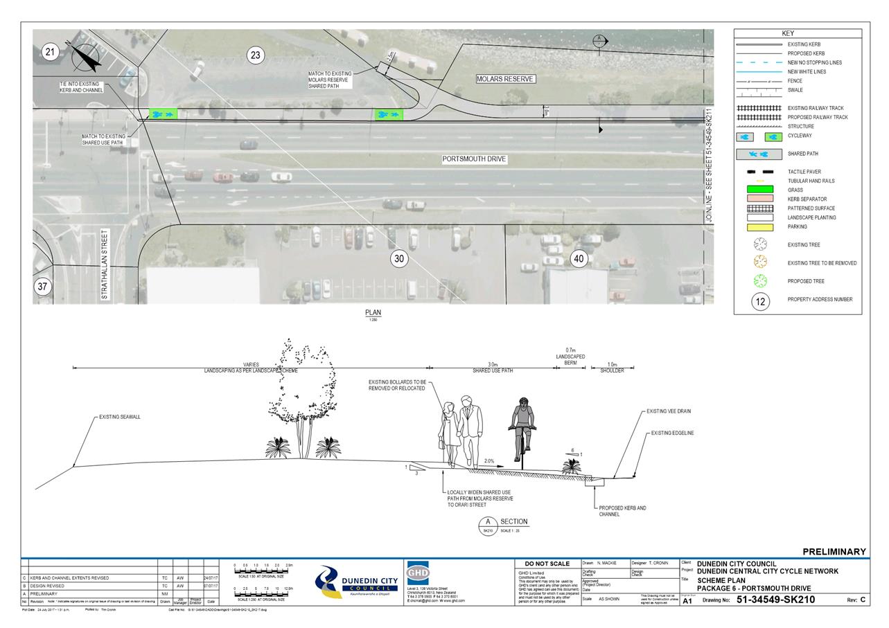
|
Infrastructure Services and
Networks Committee
14 August 2017
|
|
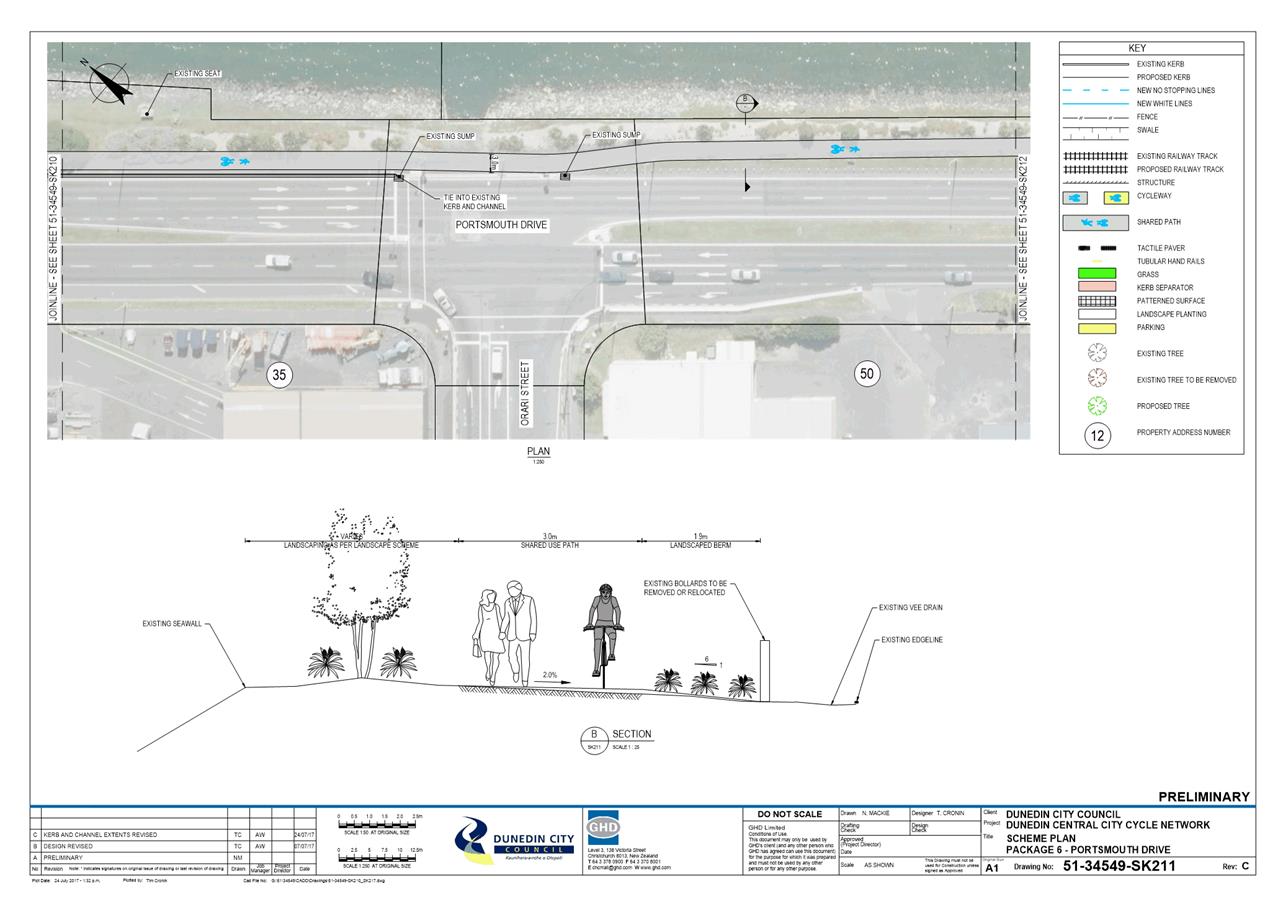
|
Infrastructure Services and
Networks Committee
14 August 2017
|
|
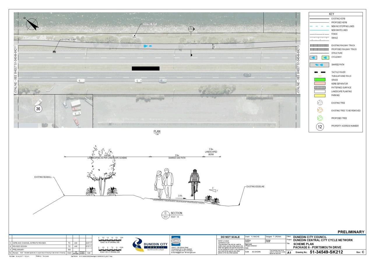
|
Infrastructure Services and
Networks Committee
14 August 2017
|
|
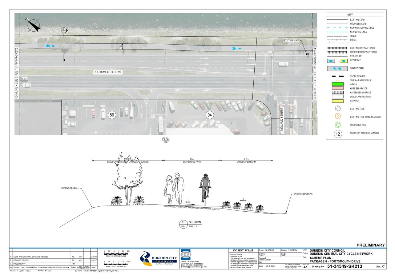
|
Infrastructure Services and
Networks Committee
14 August 2017
|
|
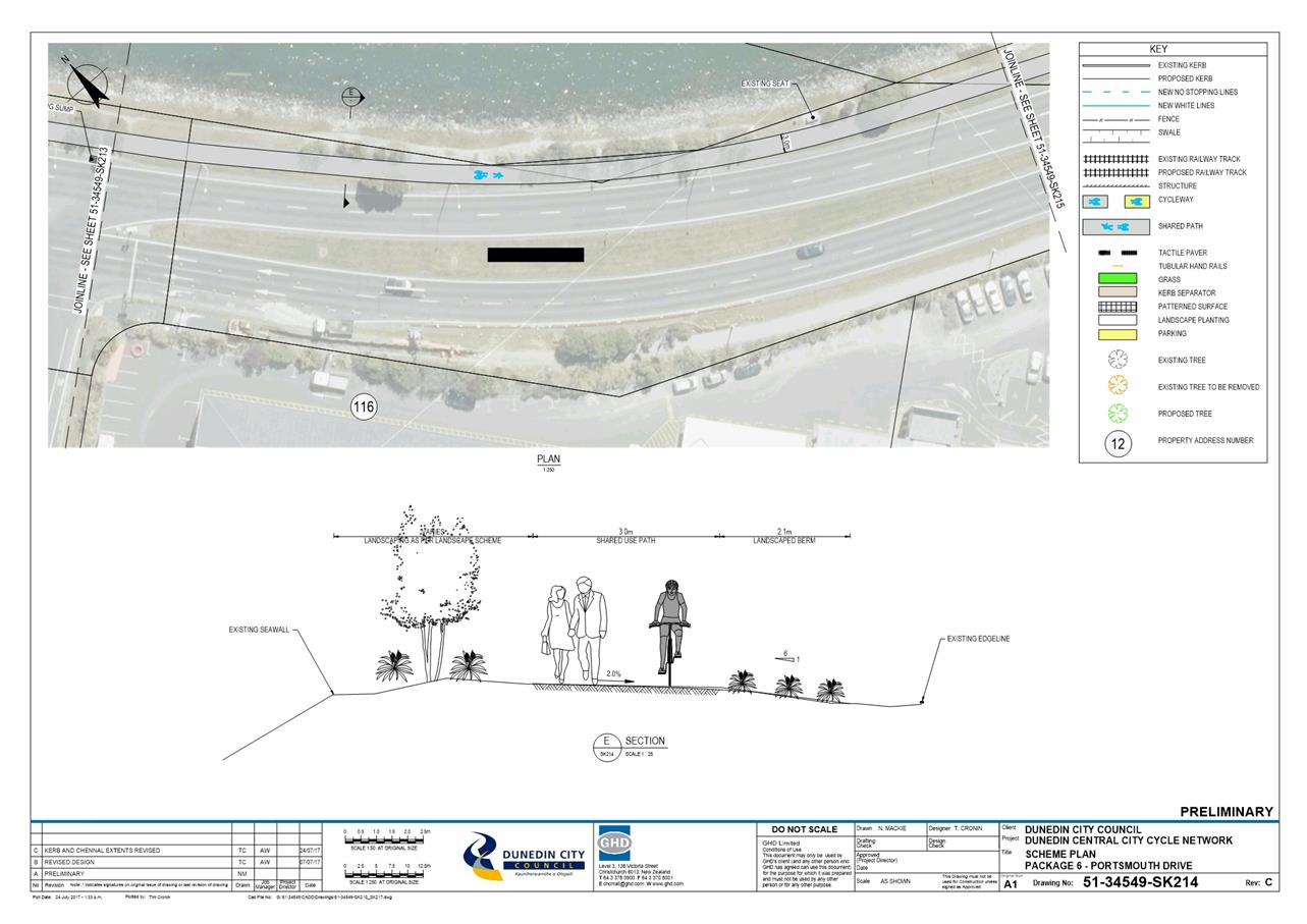
|
Infrastructure Services and
Networks Committee
14 August 2017
|
|
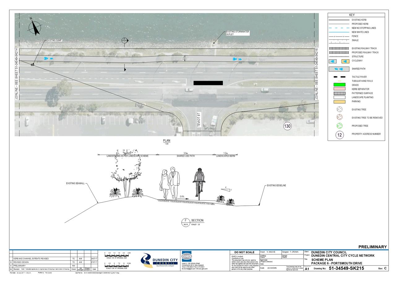
|
Infrastructure Services and
Networks Committee
14 August 2017
|
|
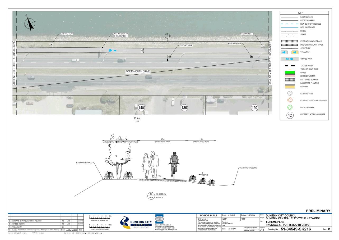
|
Infrastructure Services and
Networks Committee
14 August 2017
|
|