|

|
Regulatory Subcommittee
12 October 2021
|
Part
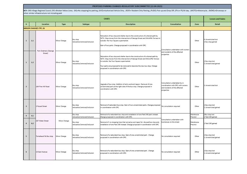
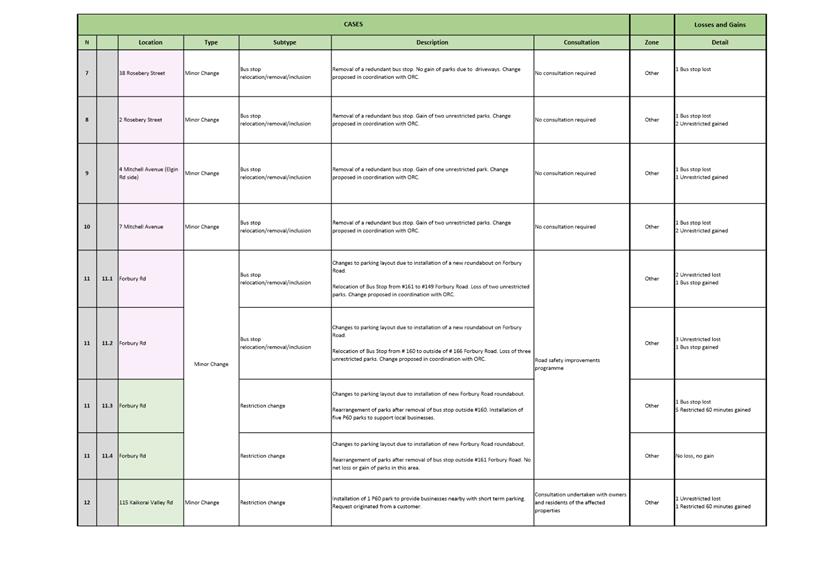
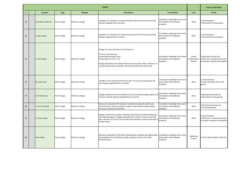
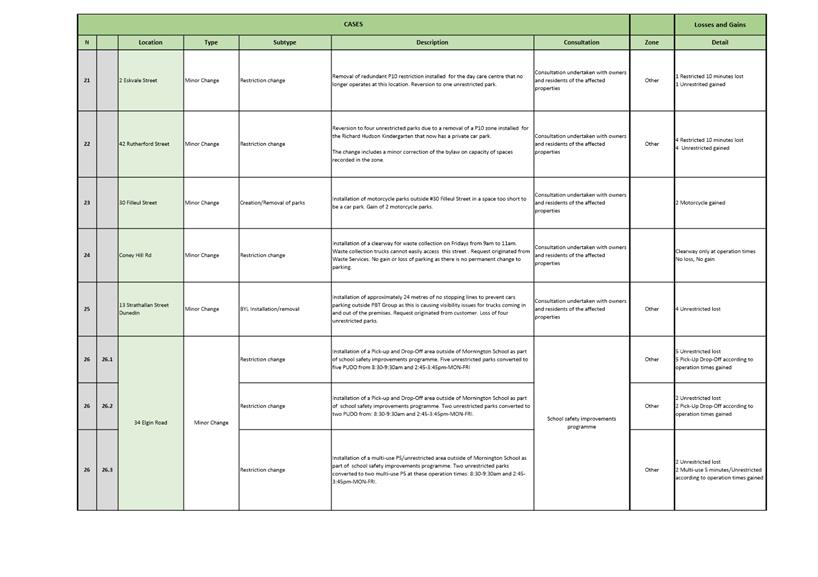
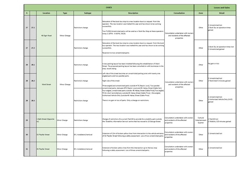
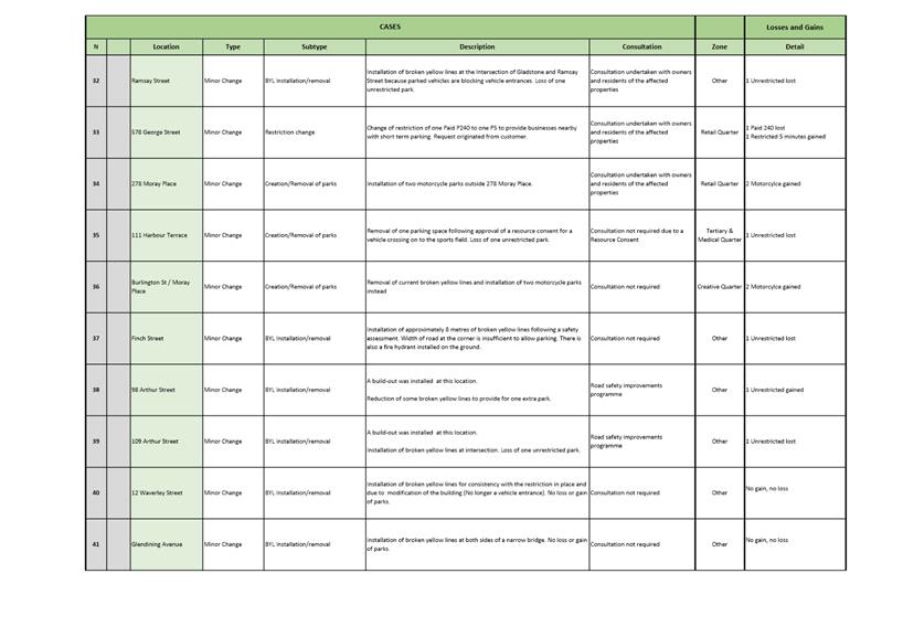
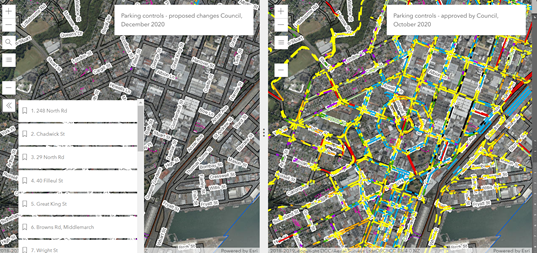
A Reports
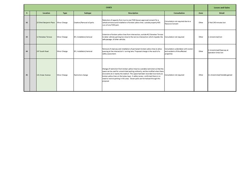
Proposed parking changes-October 2021
Department: Transport
EXECUTIVE SUMMARY
1 This
report seeks support from the Regulatory Subcommittee for minor changes and
clarifications to parking restrictions.
|
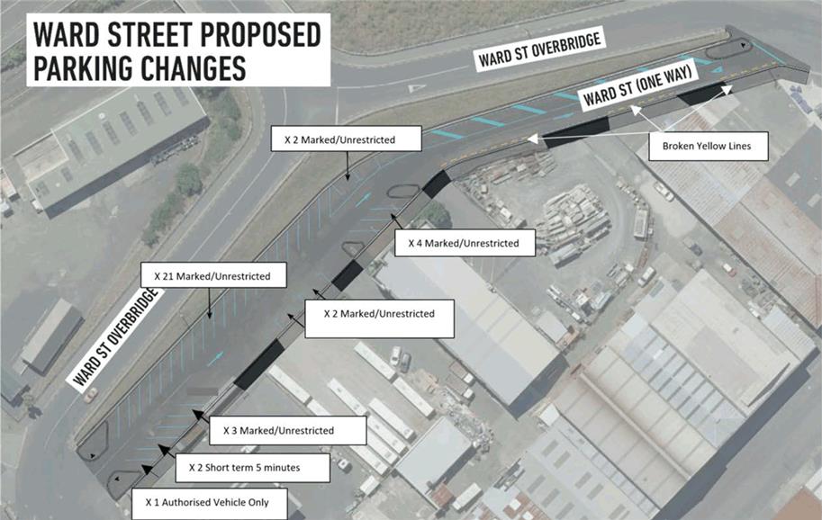
RECOMMENDATIONS
That the Subcommittee:
a) Recommends Council to approve the proposed changes
to parking restrictions shown in the October 2021 update of the Dunedin City
Council's traffic and parking restrictions database, https://tinyurl.com/ParkingOctober2021
|
BACKGROUND
2 Traffic
and parking controls contribute to the objectives of the Dunedin Integrated
Transport Strategy 2013, particularly by supporting the achievement of a safe,
efficient and accessible transport network.
3 Council
maintains a GIS map
database of traffic and parking restrictions (the database) which reflects all
on-street parking restrictions that are implemented with markings and/or signs.
4 Parking
controls are made under the Traffic and Parking Bylaw. The Regulatory
Subcommittee (Subcommittee) has the delegation to consider changes to parking
controls and to make recommendations to Council which can approve traffic
restrictions and parking controls.
DISCUSSION
5 The
Council receives a range of unsolicited requests to change parking restrictions
from individuals and businesses. When considering these requests, staff assess
a range of factors including safety concerns, commuters’ needs,
commercial user’s needs, the road width and topography, traffic flow,
neighbouring on-street parking spaces, visibility concerns and crash
statistics. If a proposed change is supported by staff, consultation is
undertaken with residents, businesses and property owners in the area to
demonstrate support for the requested change.
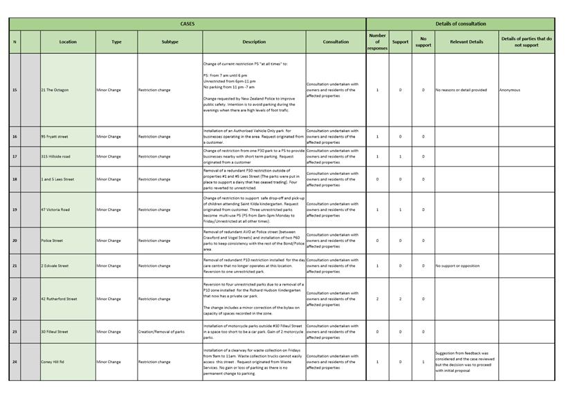
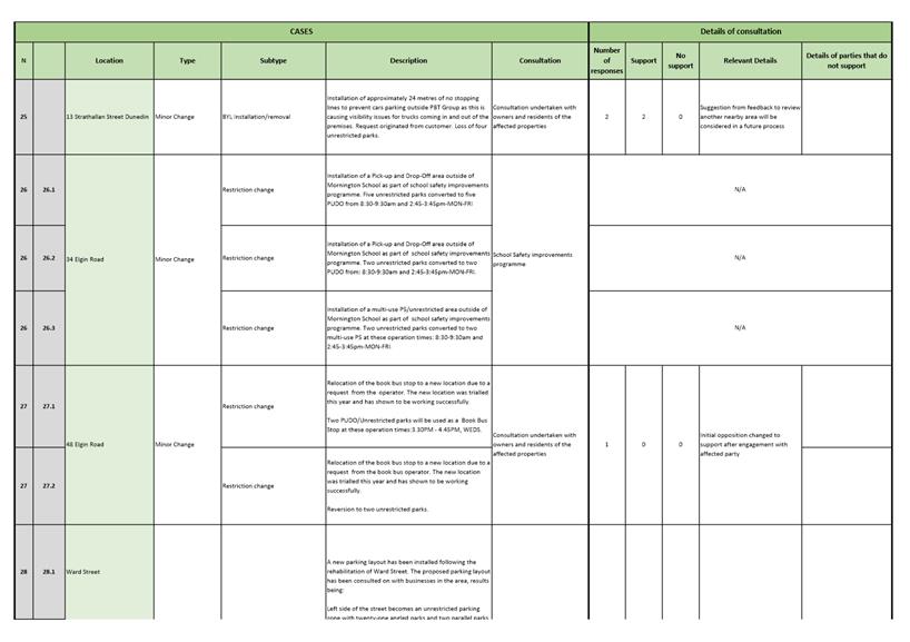
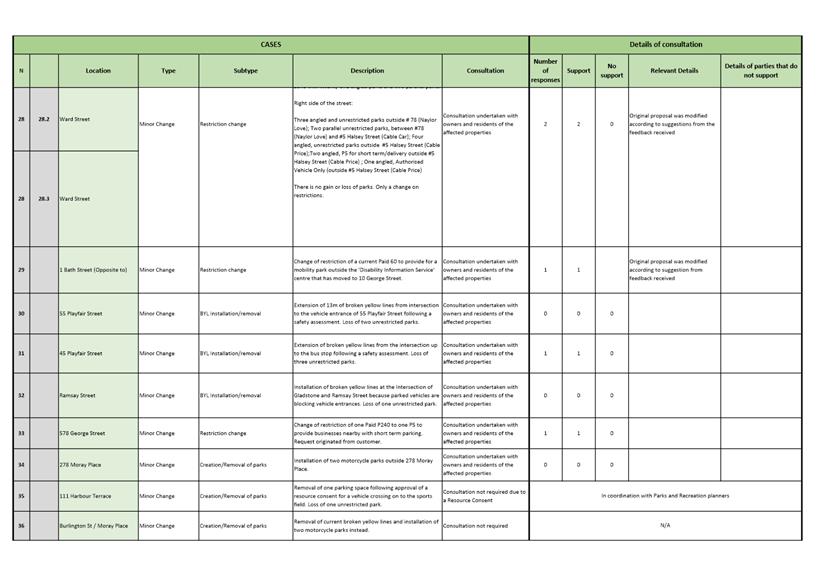
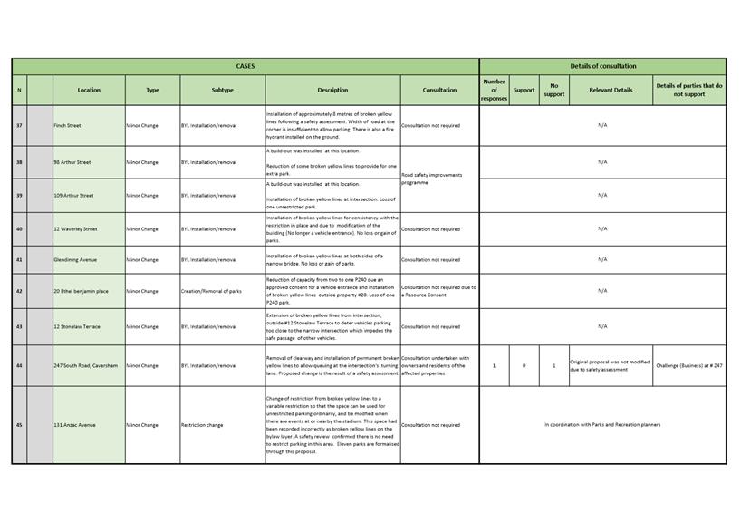
6 Recommended
changes and clarifications to parking restrictions are shown in the database at
https://tinyurl.com/ParkingOctober2021
and detailed in Attachments A (TPC 26-Minor Changes) and B (TPC
27-Clarifications and corrections). The GIS layer includes a bookmark feature
which links the numbered cases presented in the tables of Attachment A and
Attachment B, to their specific location on the GIS layer as seen in the
example below.

7 The
recommended minor parking restriction changes detailed in Attachment A (TPC-26
Minor Changes) include:
a) Parking
changes to improve safety, efficiency or access, where appropriate engagement
has been carried out with affected parties.
b) Changes
to improve the operation of the bus network where appropriate engagement with
affected parties has been carried out by the Otago Regional Council (ORC).
8 A
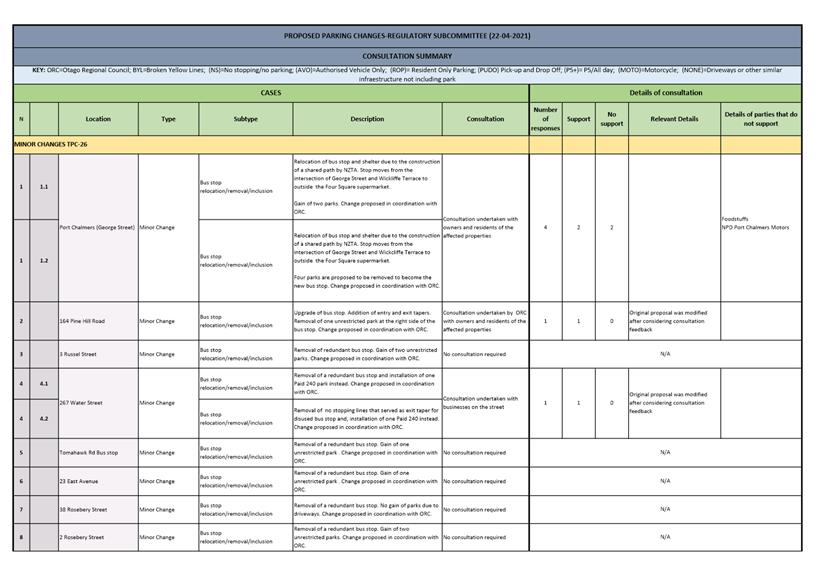
summary of consultation with affected parties, including owners, residents and
businesses in the area is shown in Attachment C (Consultation Summary).
9 The
most notable change is a proposed bus stop relocation due to the construction
of a shared path in Port Chalmers by Waka Kotahi NZ Transport Agency, from the
intersection of George Street and Wickliffe Terrace, to the first pedestrian
crossing on George Street. This will allow users of the new cycle path to use
the crossing to access the left lane.
10 The
bus stop is currently located outside of property #57 George Street. A previous
proposal to relocate to outside #71 George Street was rejected by staff earlier
in the year after feedback from consultation was considered. It is now proposed
to move the bus stop to outside of the Four-Square Supermarket on George
Street. This option was presented to the West Harbour Community Board’s
meeting of 11 August 2021.
11 By
relocating the stop to the front of the Four-Square supermarket, four car parks
are proposed to be removed to provide the bus stop with appropriate entry and
exit tapers. Two parks would be gained at the location of the current stop.
This change was proposed in coordination with Waka Kotahi and the ORC. Because
the bus stop is located on a state highway, consultation has been undertaken on
behalf of Waka Kotahi by the DCC. Owners and residents of the street have been
consulted. A traffic engineer has reviewed the feedback and conducted a site
visit. They are satisfied that the proposed location for the bus stop is
satisfactory. More detail about the feedback received can be seen in Attachment
C (Consultation Summary).
12 Staff
have received a request from Waste and Environmental Solutions Group to install
a clearway for two hours, once a week, on the narrowest section of Coney Hill
Road to allow safe passage of trucks that are having trouble accessing
properties for rubbish and recycling collection. Owners and residents of the
area were consulted, and one property owner and resident provided feedback
opposing the change. This feedback was considered and discussed with Waste and
Environmental Solutions, and no changes were made to the original proposal.
Approximately 8 parks are affected for two hours, once a week (Fridays from 9am
to 11am), but there is no permanent loss of parking due to this measure.
13 Other
cases of note relate to the road safety improvements programme:
· The
roundabout at the Forbury Road and Bay View Road intersection was completed in
early September 2021. As a result of these improvements, changes to the parking
layout are proposed. This includes the relocation of 2 bus stops in
coordination with ORC, and the reconfiguration of some parking. Overall, no
parking is lost, though some restrictions would be changed.
· The school
safety improvements programme has implemented a new parking layout on Elgin
Road, near Mornington School. The school requested a Pick-Up and Drop-Off zone
outside of its premises to allow students to have safer access to the school.
The result on parking is the change of 7 unrestricted parks to 5 Pick-Up and
Drop-Off and, 2 multi-use 5 minutes/unrestricted parks (8:30-9:30 am and
2:45-3:45 pm-MON-FRI.) There is no permanent loss of parking due to this
measure.
14 Earlier
in the year the road reserve on Ward Street between Halsey Street and Wickliffe
Street was rehabilitated and upgraded, and a one-way restriction on this
section of Ward Street was approved by Council in February 2021. Angled car
parks were created to replace the informal parking arrangement that had existed
previously. The Regulatory Subcommittee is asked to consider changes to time
restrictions for the new parking layout. The results of engagement with
businesses in the area has shown that the preference is to maintain the
majority of parks as unrestricted and to provide some short-term parking for
customers. For more detail please see Attachment D-Ward Street Map.
15 From
the changes and improvements related to the bus network detailed on the table
Attachment A (TPC-26 Minor Changes), it is proposed that 9 parks be reallocated
to support the creation or relocation of bus stops and 18 would be gained due
to removal of bus stops, resulting in a net gain of 9 parks. The changes
proposed are part of the DCC and ORC common strategy for improving the bus
network.
16 In
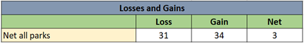
total, it is proposed there will be a net gain of 3 parking spaces across the
city. The table below shows the net losses and gains due to the proposed
parking changes:
There is an increase of parking in the central city. The
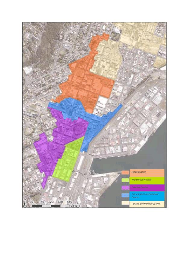
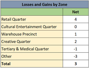
table below shows the net losses and gains on parking changes by zone (See
Attachment E-Map Zones):
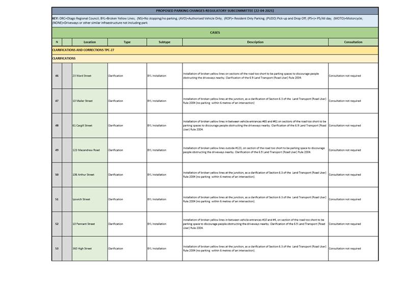
17 Clarification
of parking restrictions and corrections to the database are detailed in TPC-27
(Attachment B). They do not change current parking restrictions, but include:
a) Markings
or signs which will clarify parking controls that are already in place. Changes
may make existing markings or signs clearer or reinforce existing rules (for
example installation of no-stopping lines to clarify that no vehicles may stop
within one metre of a driveway or within six metres of a junction under the
Land Transport (Road User) Rules 2004). These clarifications are considered
necessary for access or safety reasons and are an exception to Council’s
general approach not to mark anything that is currently enforceable under
existing rules.
b) Corrections
to the database that have been made to accurately reflect the parking
restrictions which are on the ground.
OPTIONS
Option
One – Recommended Option
18 That
the Subcommittee approves the proposed changes to the traffic and parking
controls database.
Advantages
· Improves
safety, efficiency and access on the transport network by:
ü Enabling
property access by prohibiting obstructive parking, making existing parking
controls clearer, and providing for access to new driveways.
ü Providing
an improved and enforceable framework of parking restrictions.
ü Providing
appropriate length of parking stay according to the surrounding land uses.
ü Increases
visibility at intersections.
· Improves
public transport infrastructure by providing bus stops to support bus services
and enables buses to safely enter and exit bus stops.
· Contributes
to achieving an integrated, affordable responsive, effective and safe transport
network.
Disadvantages
· There
are no known disadvantages.
Option
Two – Status Quo
19 Retain
the existing parking restrictions without amendment.
Advantages
· There
are no known advantages.
Disadvantages
· Does
not improve efficiency and access to the transport network.
· Does
not improve safety or reduce conflict points.
· Does
not contribute to the Integrated Transport Strategy goals.
NEXT STEPS
20 If
the Regulatory Subcommittee recommends the changes to traffic and parking
controls, a report of the proposed changes will be brought before Council for
approval.
21 If
Council approves the recommended changes to parking restrictions, these will be
implemented through appropriate signs and road markings and restrictions will
be enforced under the Traffic and Parking Bylaw.
Signatories
|
Author:
|
Paula Barragan - Policy Analyst - Transport Regulation
|
|
Authoriser:
|
Simon Spiers - Team Leader - Regulation Management
Jeanine Benson - Group Manager Transport
Simon Drew - General Manager Infrastructure and
Development
|
Attachments
|
|
Title
|
Page
|
|
⇩a
|
Attachment A-TPC
26-Minor Changes
|
16
|
|
⇩b
|
Attachment B-TPC
27-Clarifications and corrections
|
23
|
|
⇩c
|
Attachment
C-Consultation Summary
|
25
|
|
⇩d
|
Attachment D-Ward
Street Map
|
31
|
|
⇩e
|
Attachment E-Map Zones
|
32
|
|
SUMMARY OF CONSIDERATIONS
|
|
Fit with purpose
of Local Government
This report enables democratic local decision making and
action by, and on behalf of communities; and promotes the social, economic
and environmental wellbeing of communities in the present and for the future.
|
|
Fit with strategic
framework
|
|
Contributes
|
Detracts
|
Not applicable
|
|
Social Wellbeing Strategy
|
☒
|
☐
|
☐
|
|
Economic Development Strategy
|
☒
|
☐
|
☐
|
|
Environment Strategy
|
☐
|
☐
|
☒
|
|
Arts and Culture Strategy
|
☐
|
☐
|
☒
|
|
3 Waters Strategy
|
☐
|
☐
|
☒
|
|
Spatial Plan
|
☐
|
☐
|
☒
|
|
Integrated Transport Strategy
|
☒
|
☐
|
☐
|
|
Parks and Recreation Strategy
|
☐
|
☐
|
☒
|
|
Other strategic projects/policies/plans
|
☐
|
☐
|
☒
|
Establishing and changing traffic and parking restrictions
support the achievement of a safe, efficient and accessible transport
network, and supports the social and economic wellbeing of Dunedin
communities.
|
|
Māori Impact
Statement
There are no known impacts for Māori.
|
|
Sustainability
Parking control changes improve efficiency and access to
the transport network, which contribute to sustainability goals.
|
|
LTP/Annual Plan /
Financial Strategy /Infrastructure Strategy
There are no implications.
|
|
Financial
considerations
Costs for implementing the proposed changes are covered by
existing budgets.
|
|
Significance
The report is considered of low significance in terms of
the Council’s Significance and Engagement Policy.
|
|
Engagement –
external
Engagement has been
undertaken with relevant and affected parties.
|
|
Engagement -
internal
Transport, legal and parking services staff have been
consulted.
|
|
Risks: Legal /
Health and Safety etc.
This report seeks minor changes and clarifications to the GIS map database
of traffic and parking controls of the Traffic and Parking Bylaw.
|
|
Conflict of
Interest
There are no known conflicts of interest.
|
|
Community Boards
West Harbour Community Board has been informed of the
option proposed for the George Street /Wickliffe Intersection at Port
Chalmers. There are no more significant changes within the boundary of the
Community Boards.
|