|

|
Hearings Committee
11 July 2023
|
Proposed Parking Changes
Department: Transport
EXECUTIVE SUMMARY
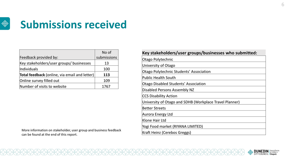
1 This report presents information for the Hearings Committee (the
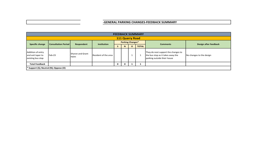
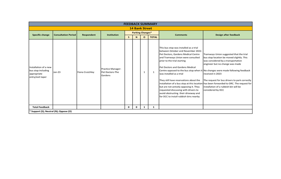
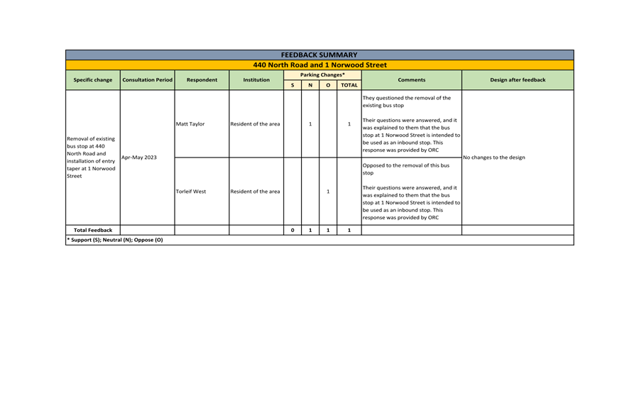
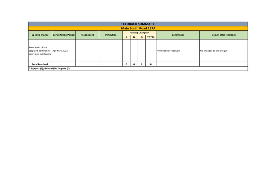
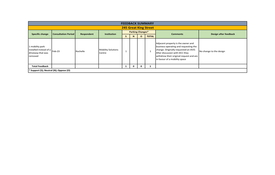
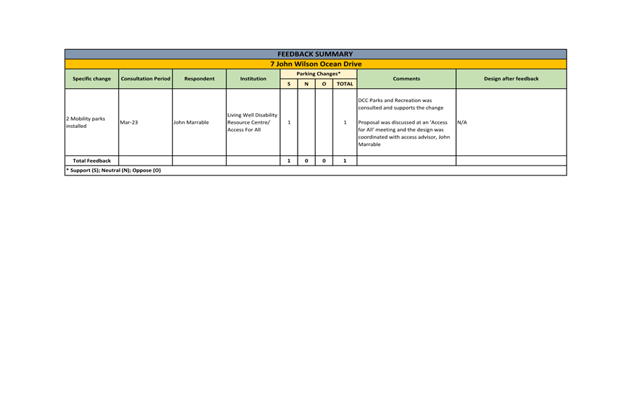
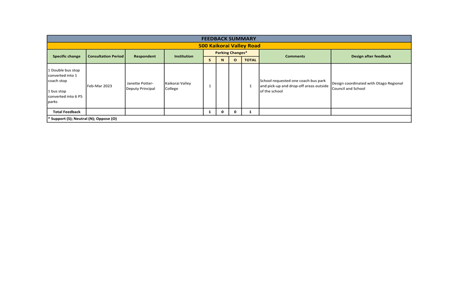
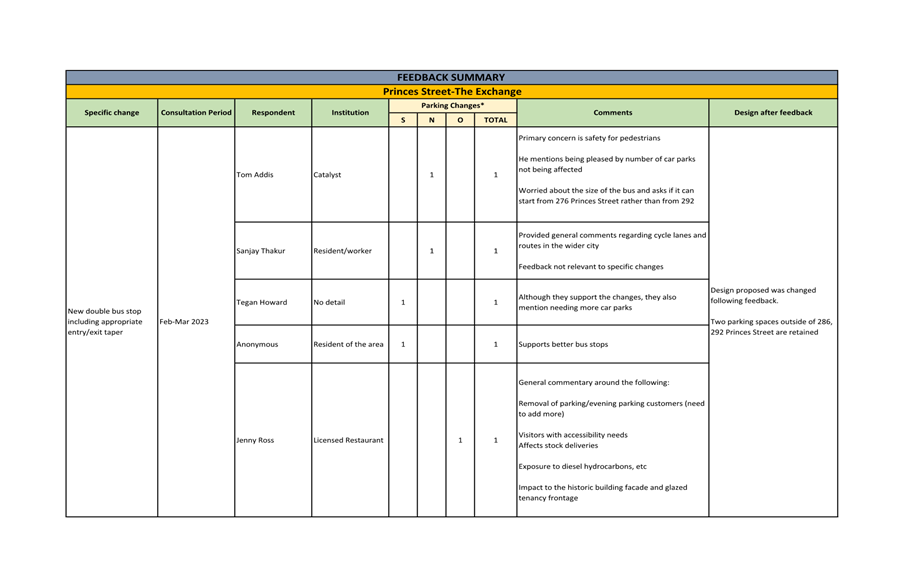
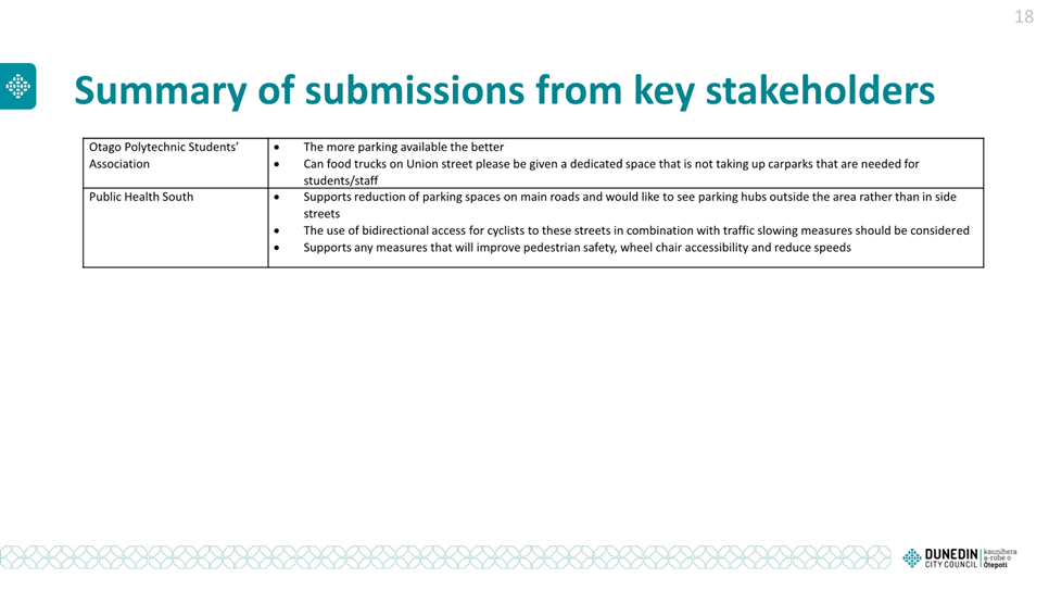
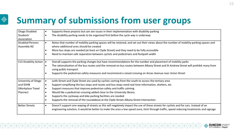
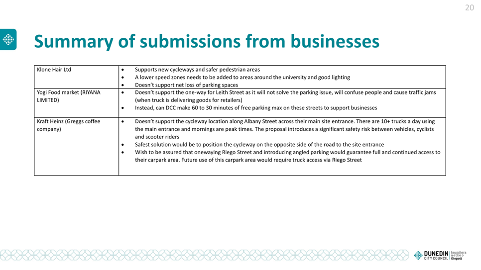
Committee) to consider changes and corrections to parking restrictions.
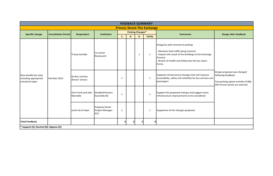
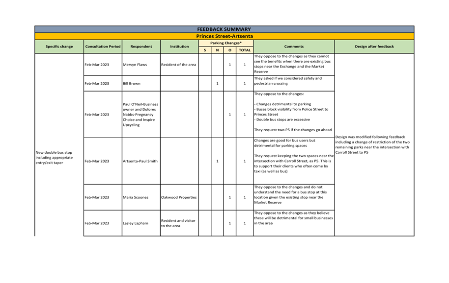
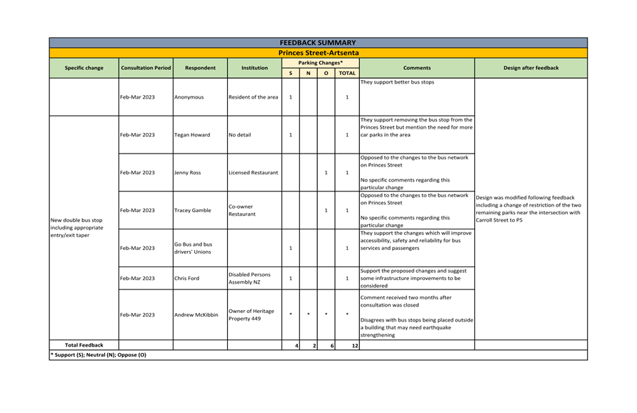
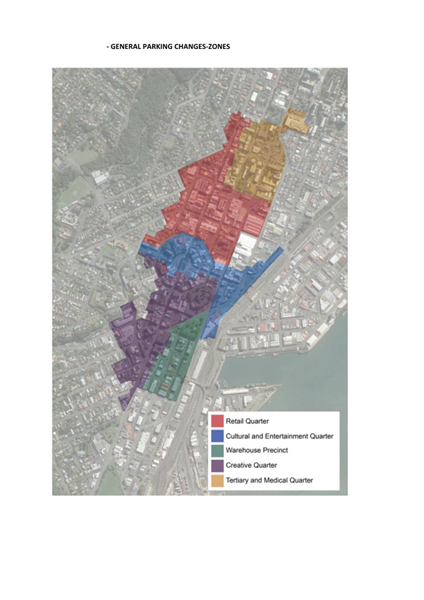
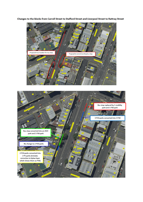
2 Consultation has been undertaken on proposed parking changes to
general parking; the Albany Street Connection Project; and the Retail Quarter
Upgrade. A feedback summary for general parking changes is attached to
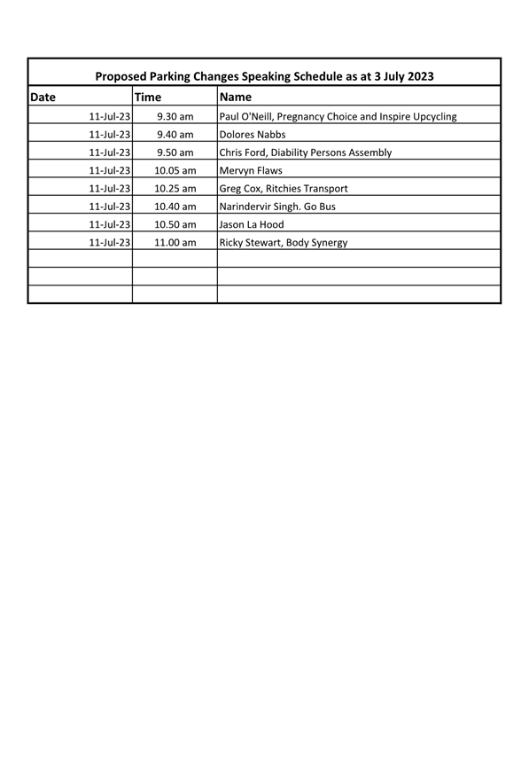
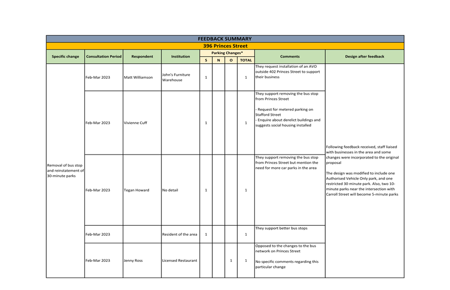
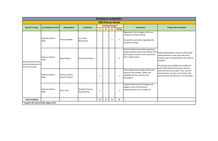
this report. Eight submitters wish to be heard in relation to changes proposed
in this report.
RECOMMENDATIONS
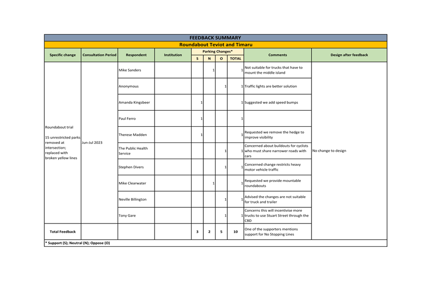
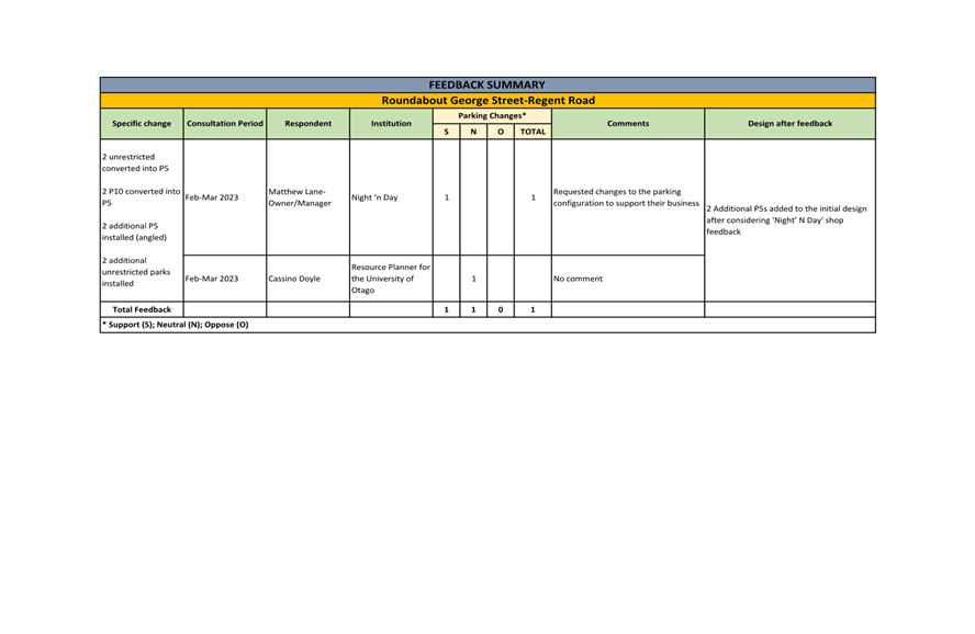
That the Committee:
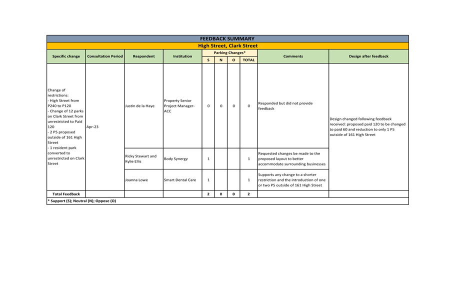
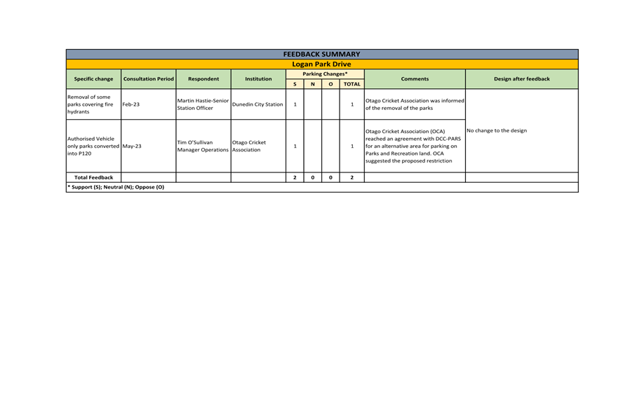
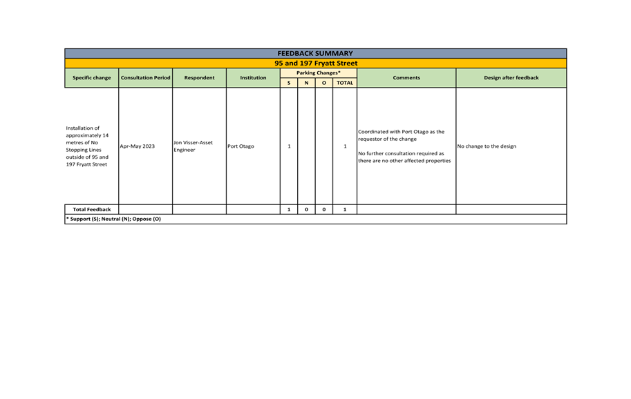
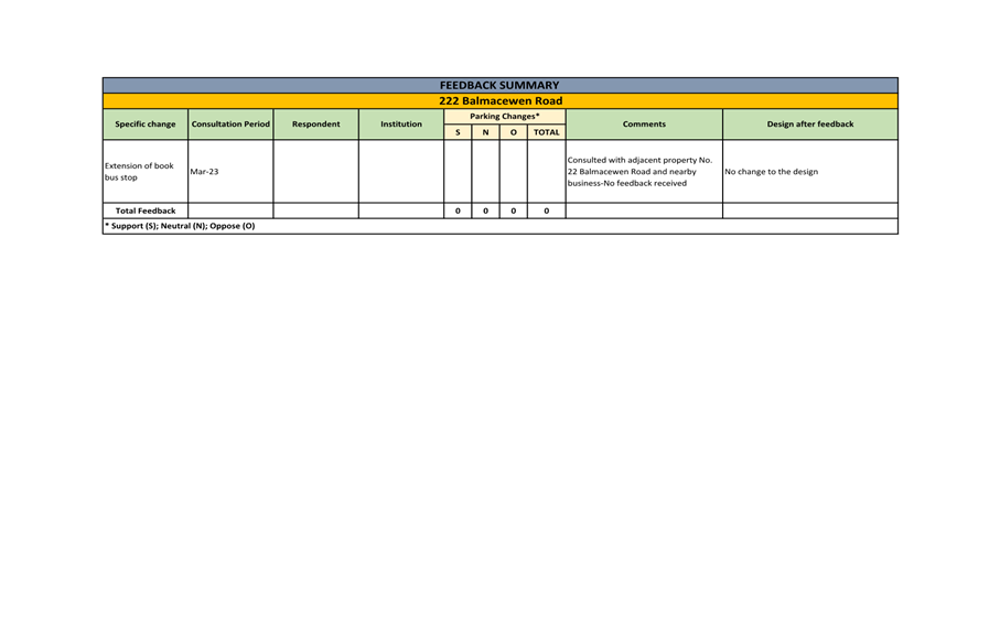
a) Recommends Council approve the proposed changes to parking restrictions
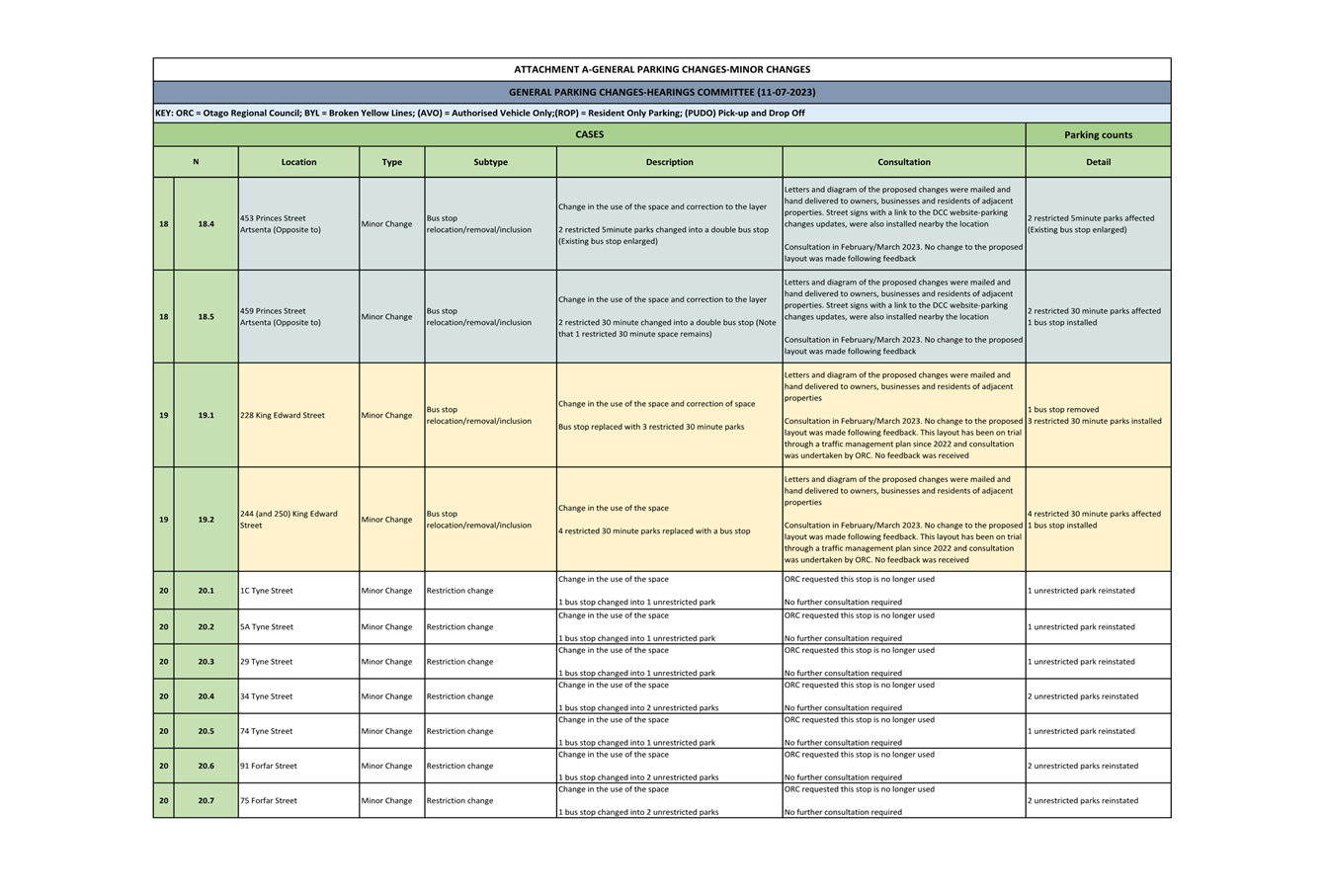
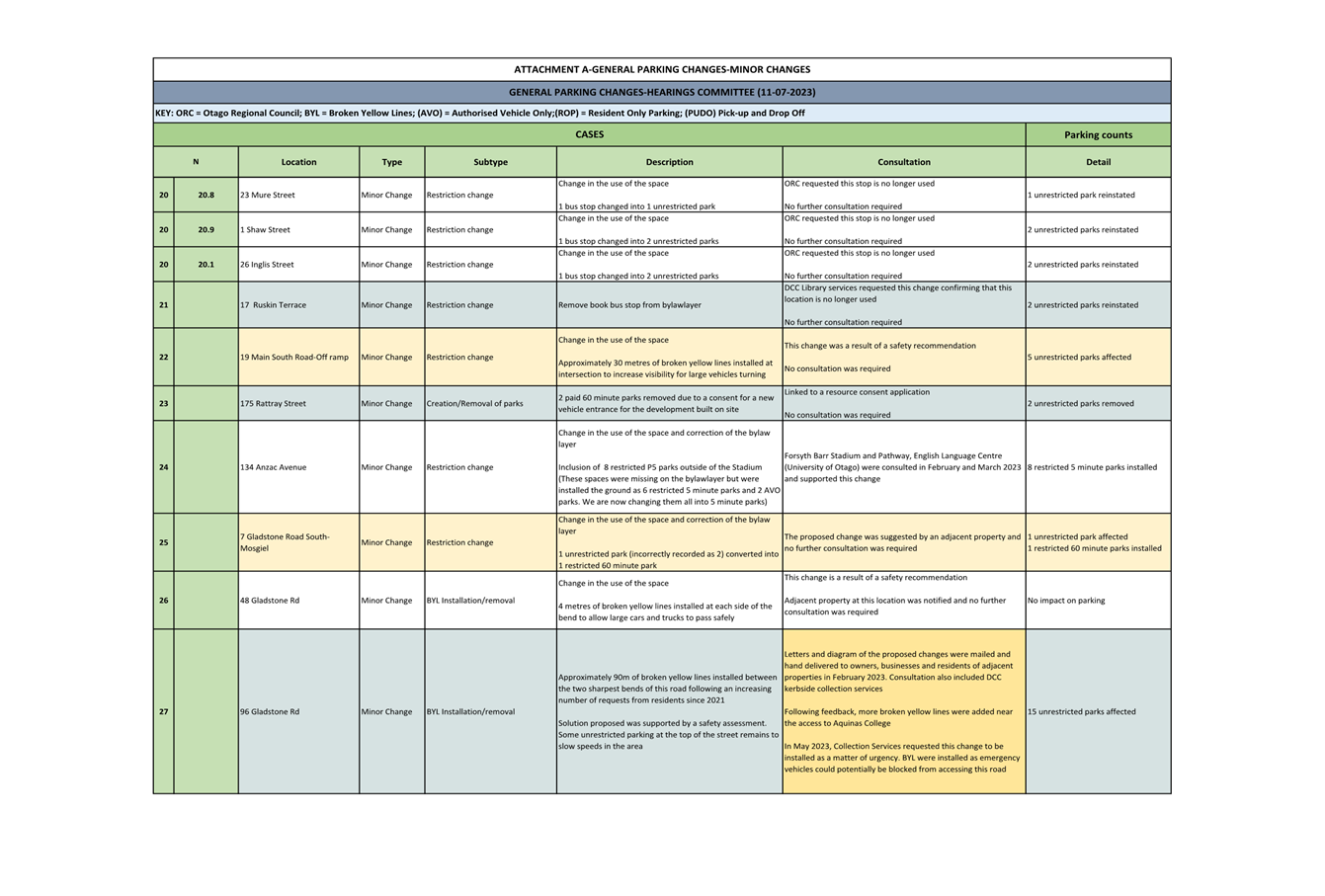
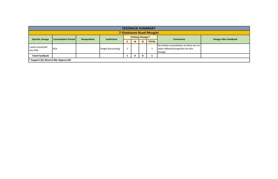
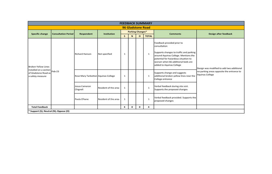
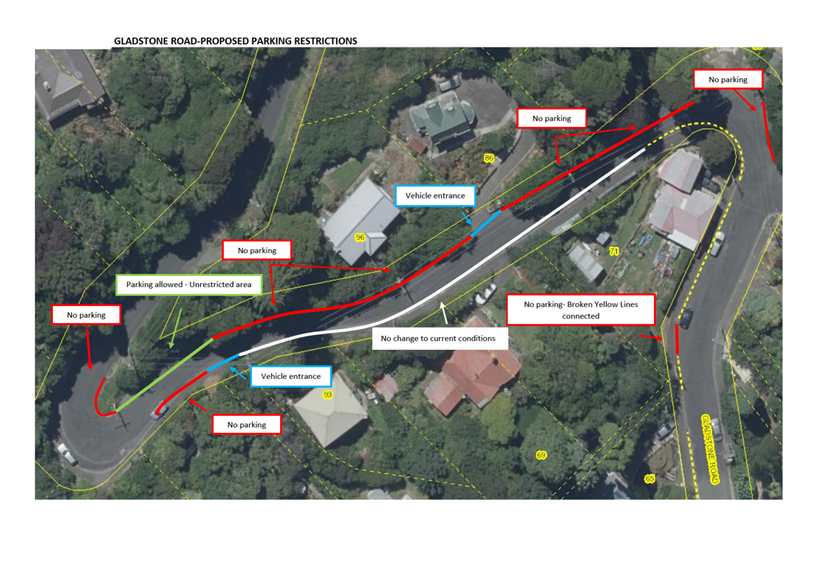
shown in the June 2023 update of the Dunedin
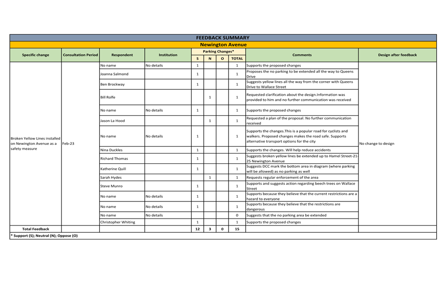
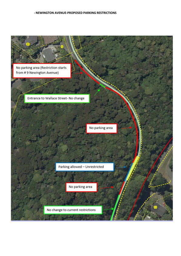
City Council's traffic
and parking restrictions database, https://tinyurl.com/ParkingJuly2023
BACKGROUND
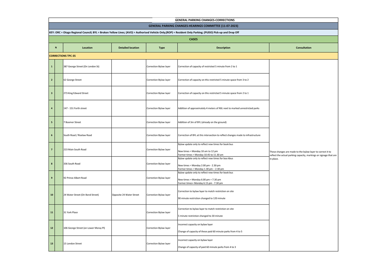
3 Traffic and parking controls contribute to the objectives of the
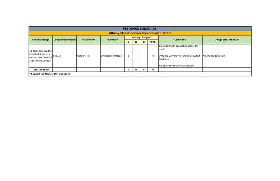
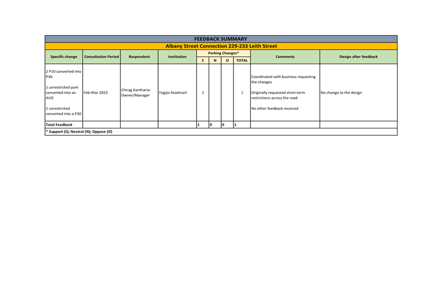
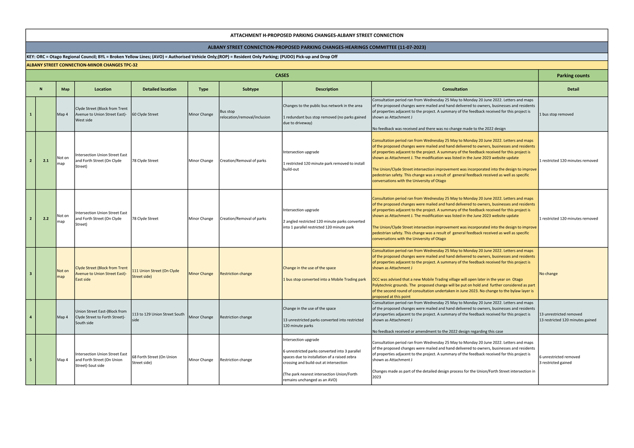
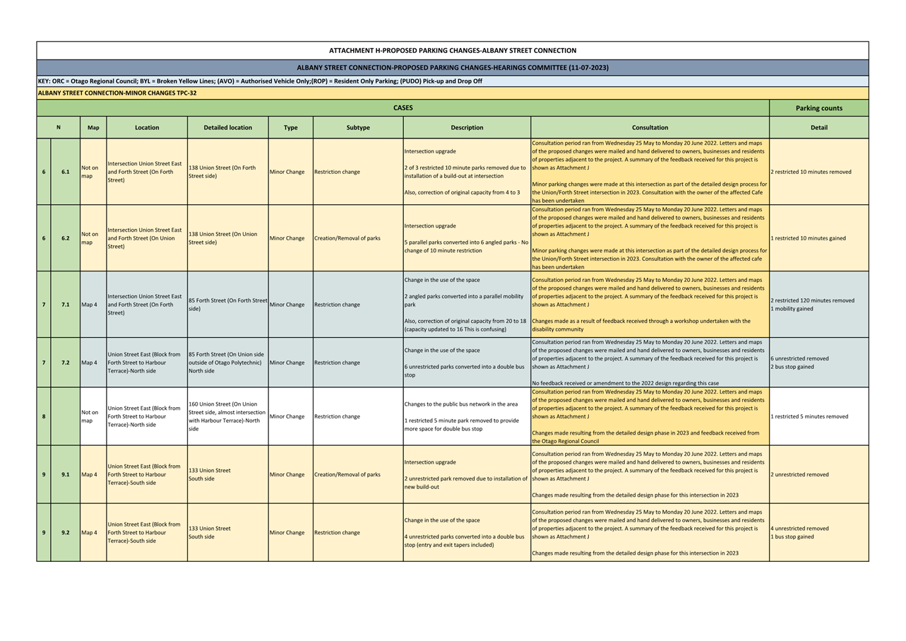
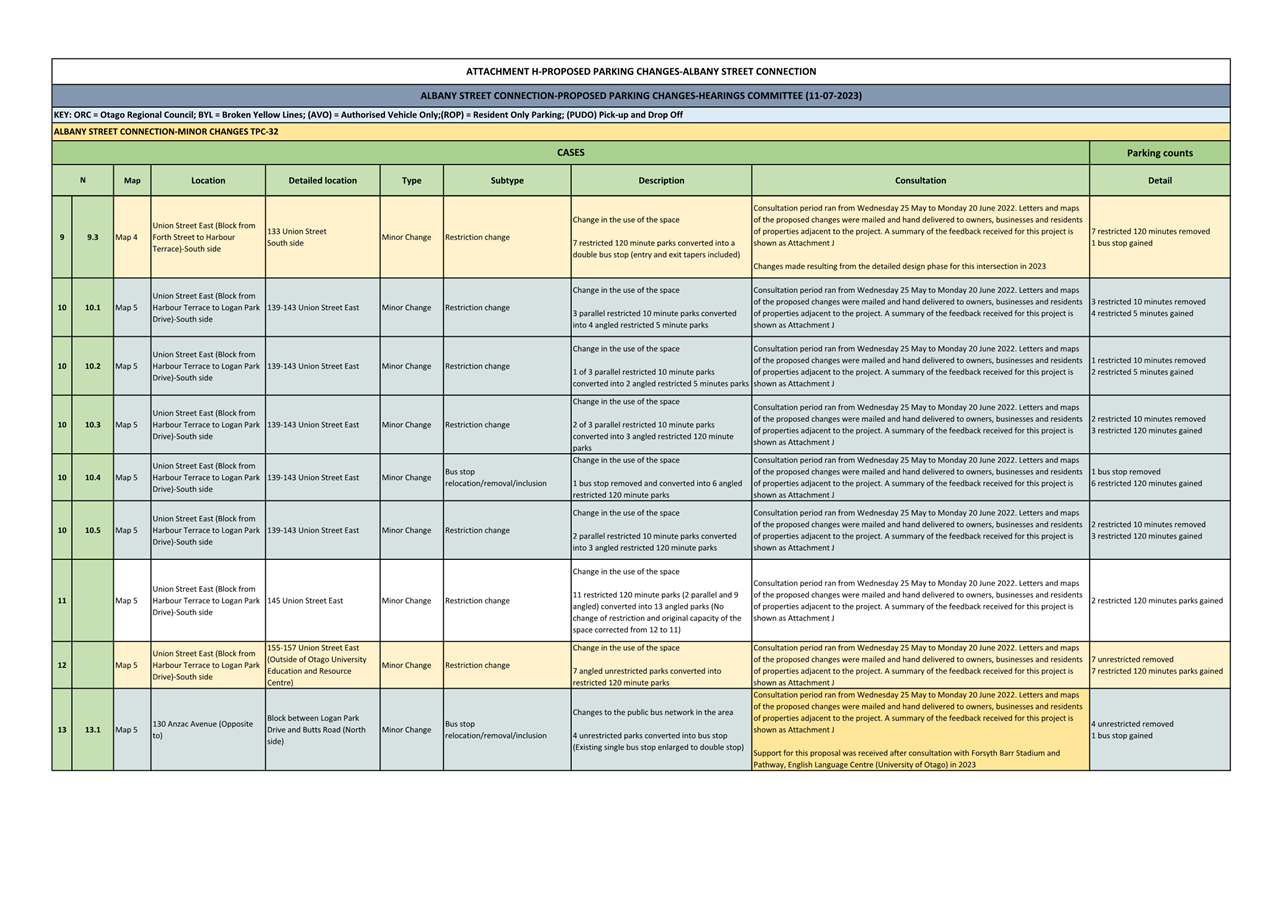
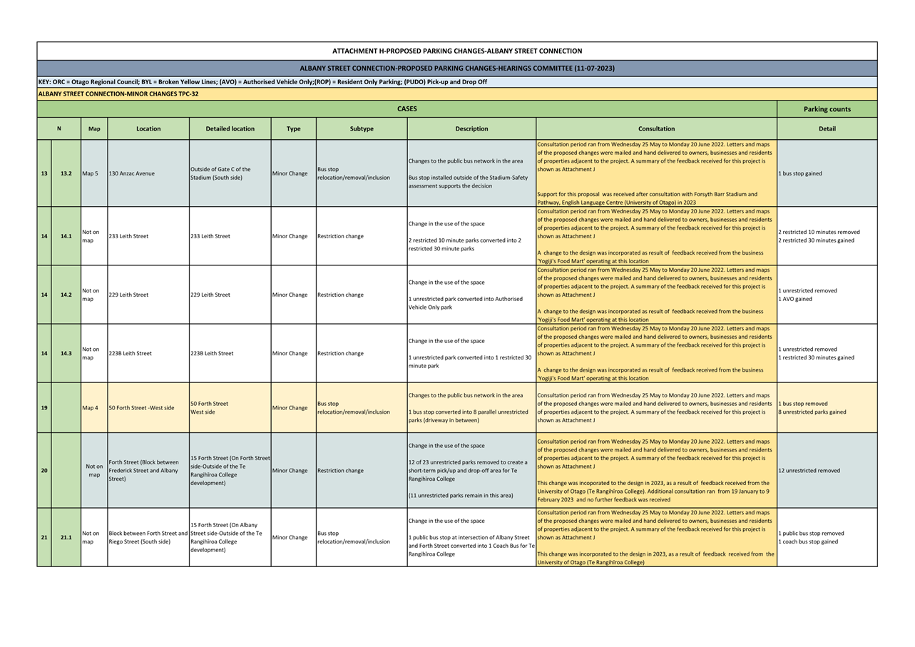
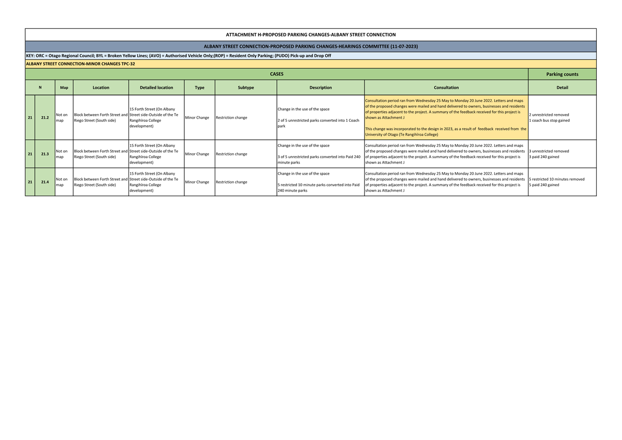
Dunedin Integrated Transport Strategy
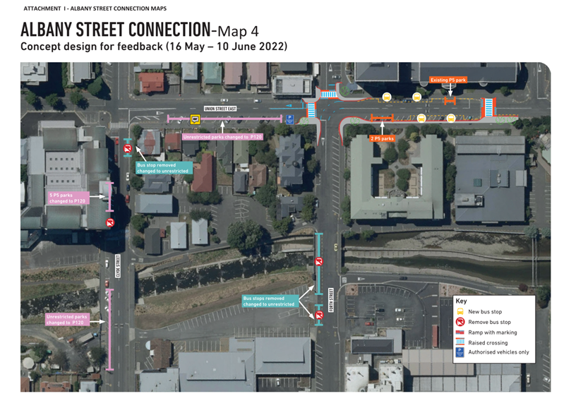
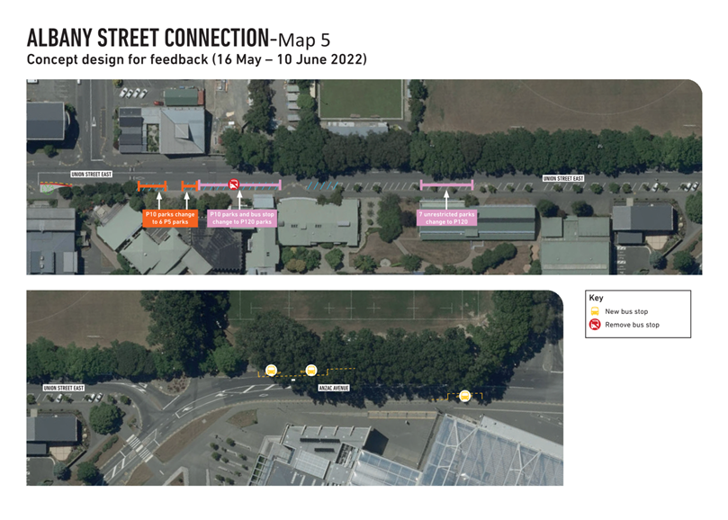
2013, by helping to achieve a safe, efficient and accessible transport network.
4 Council maintains a Geographic Information System (GIS) map database
of traffic and parking restrictions (the database) that reflects all on-street
parking restrictions that are implemented with markings and/or
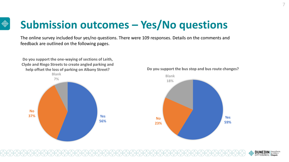
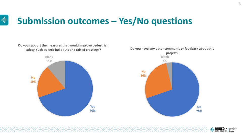
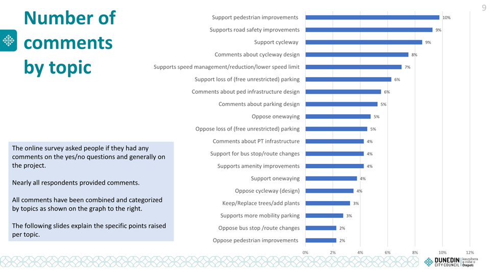
signs.
5 Parking controls are made under the Traffic and Parking Bylaw. The
Committee has the delegation to consider changes
to parking controls
and to make recommendations to
Council that can approve
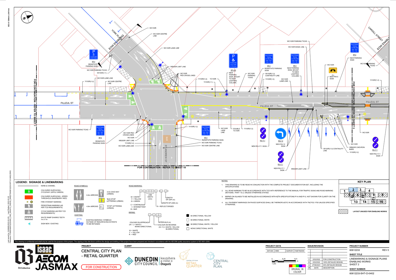
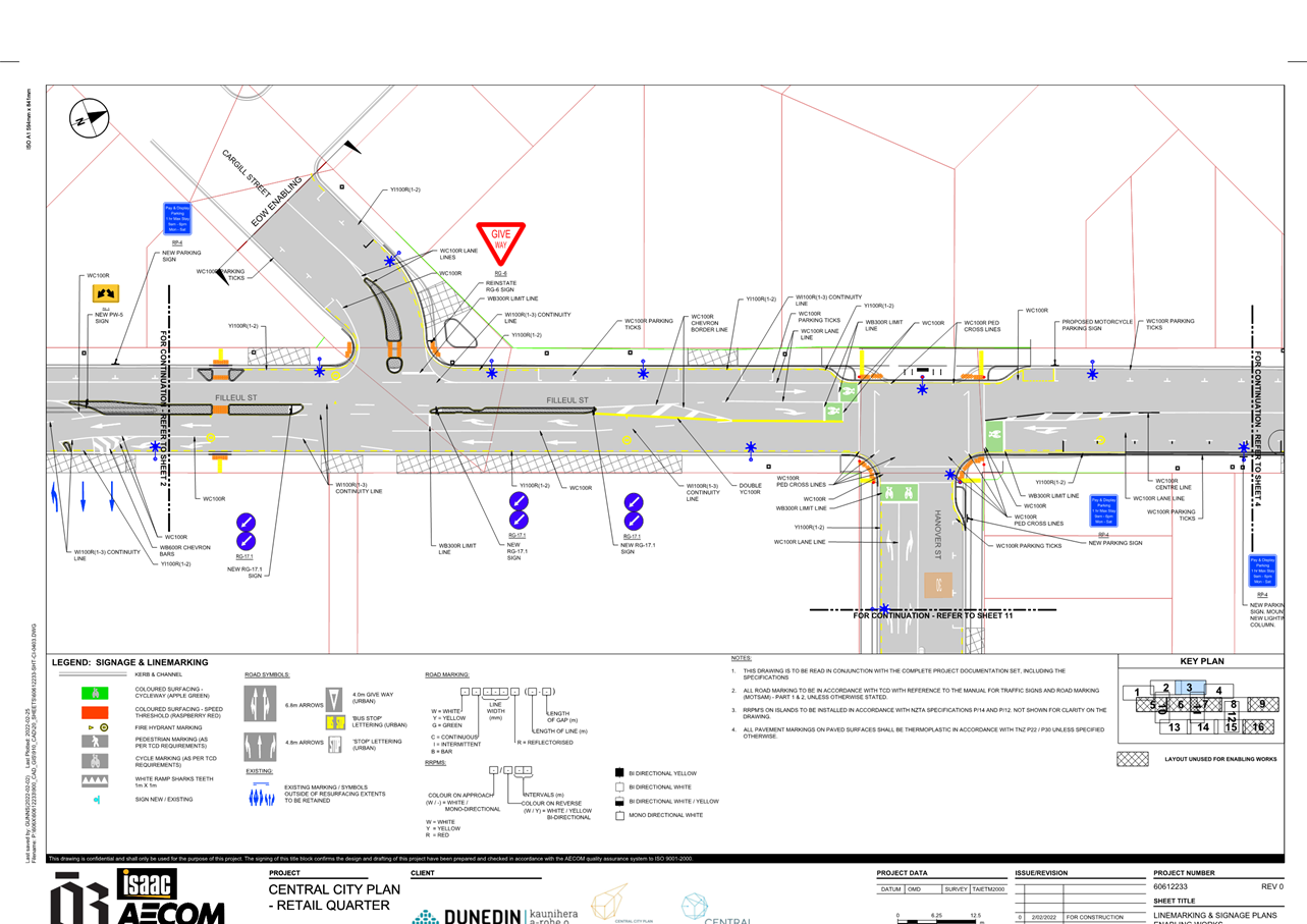
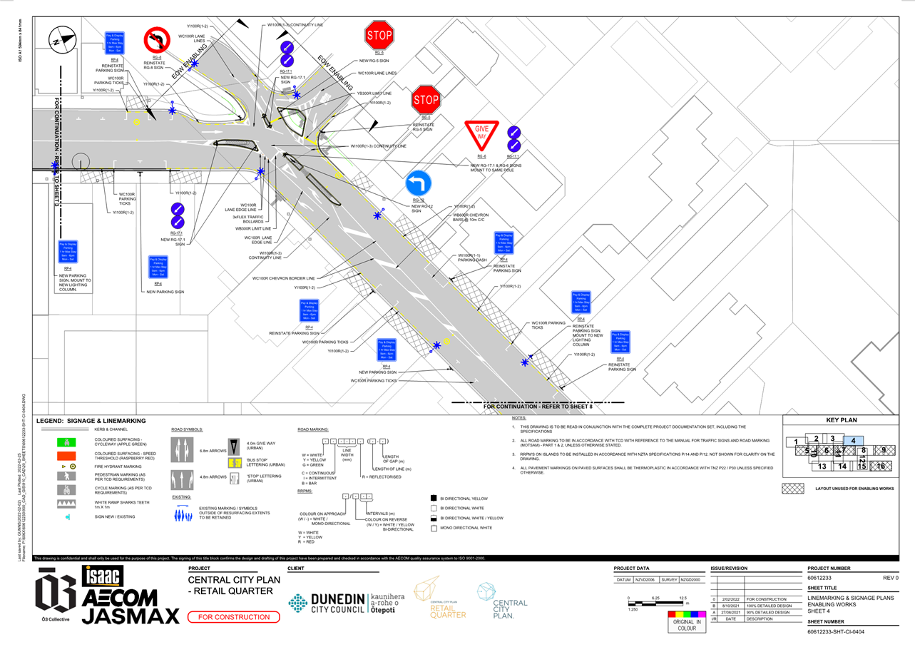
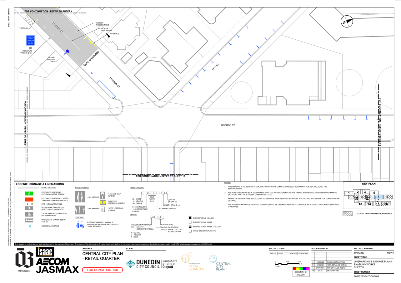
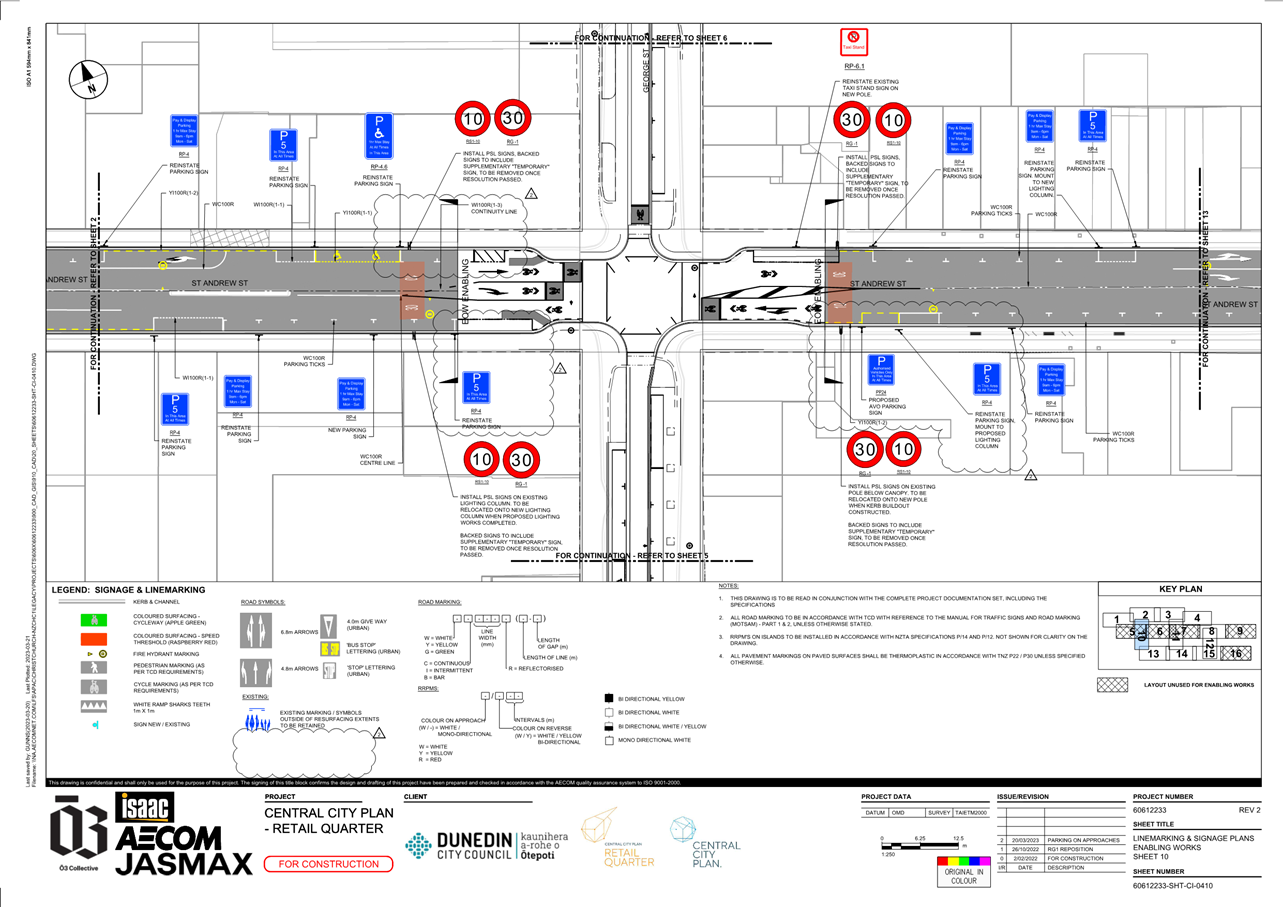
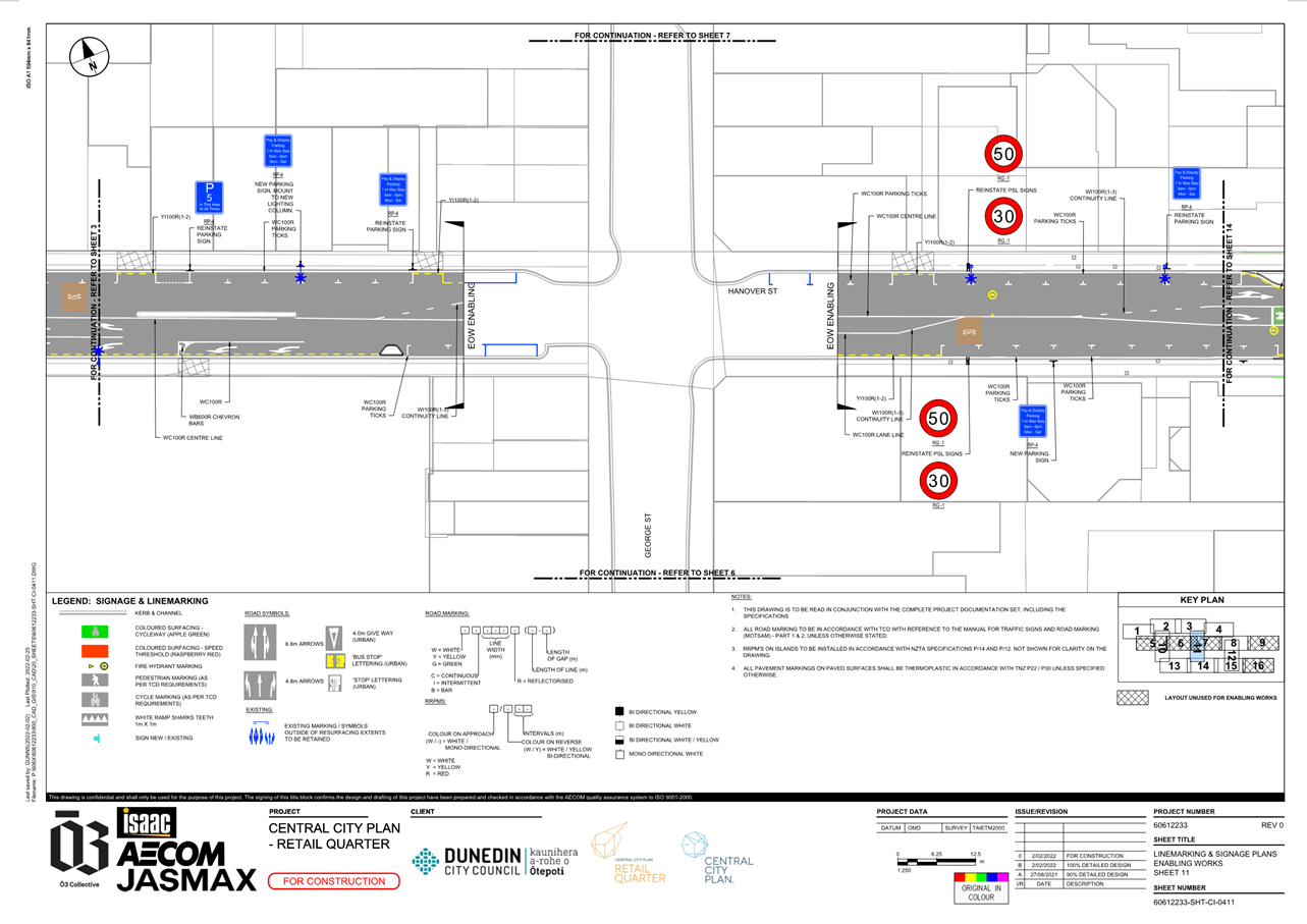
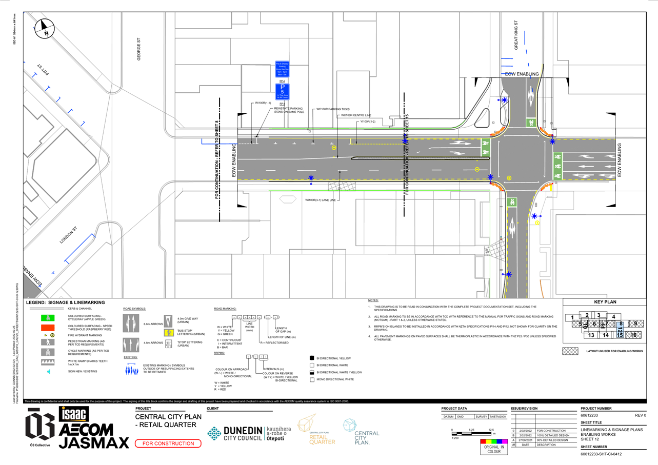
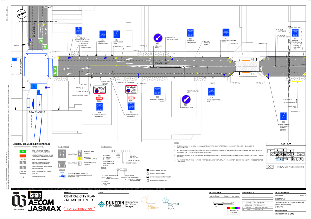
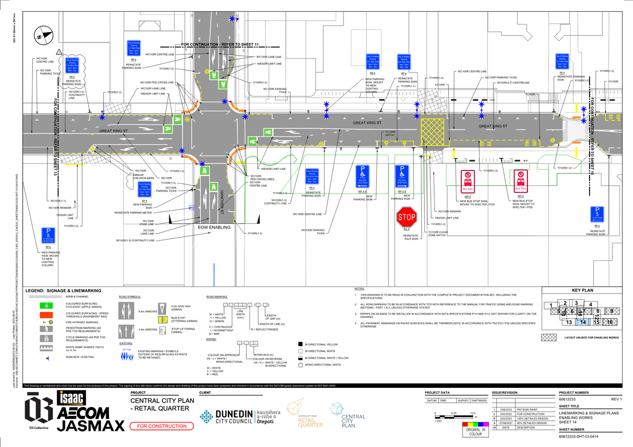
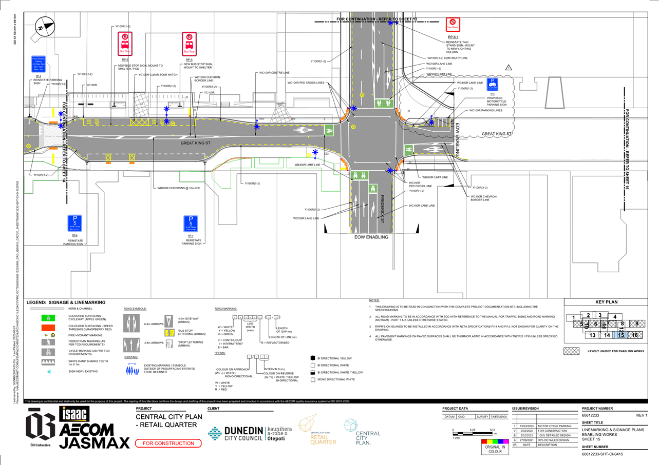
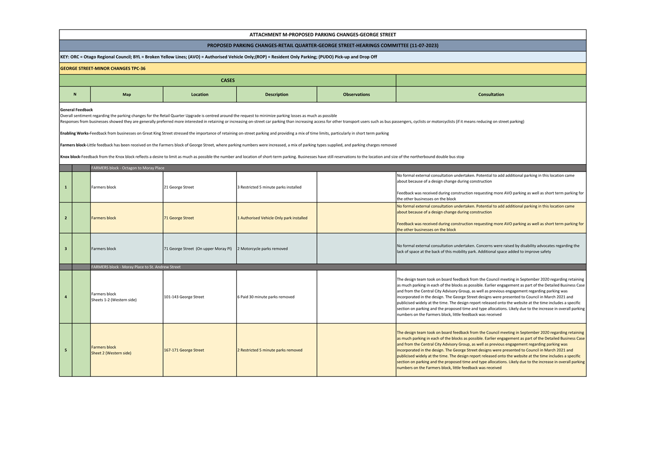
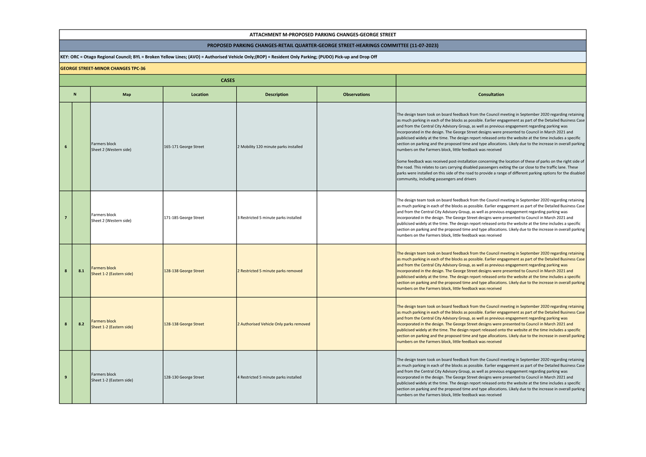
traffic restrictions and parking controls.
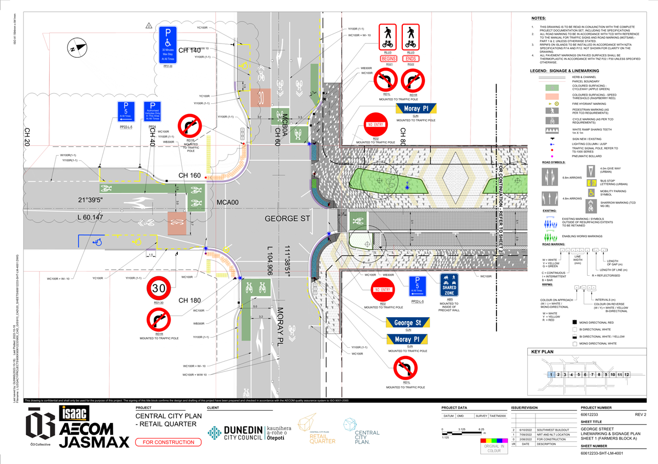
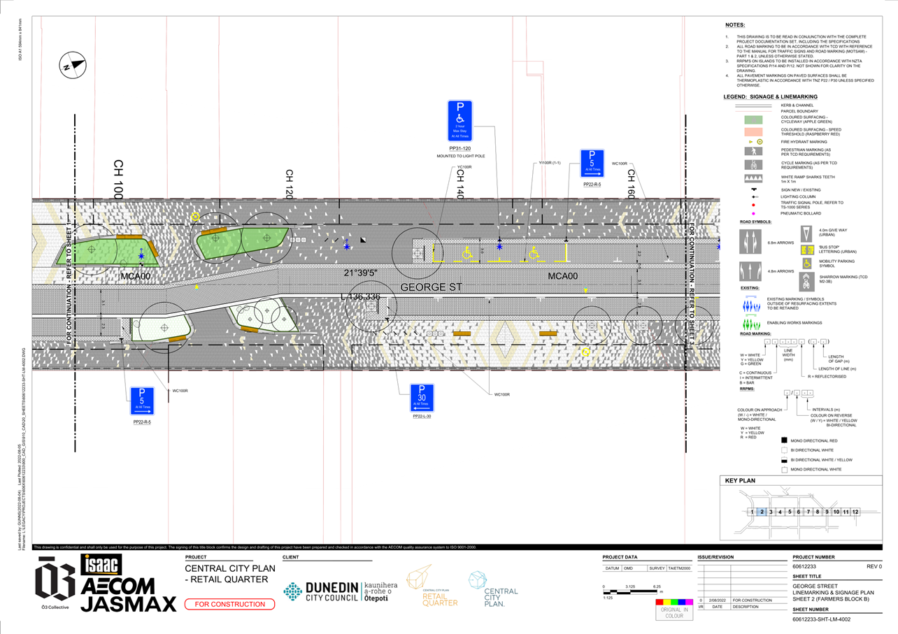
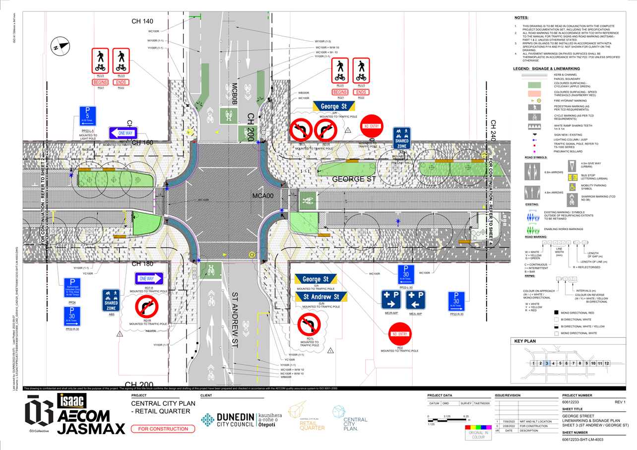
DISCUSSION
6 This report is divided into three sections:
· Minor changes -
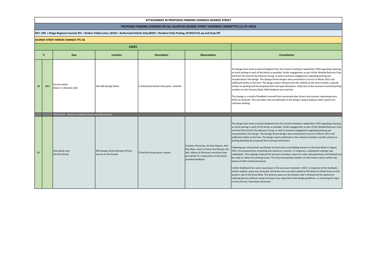
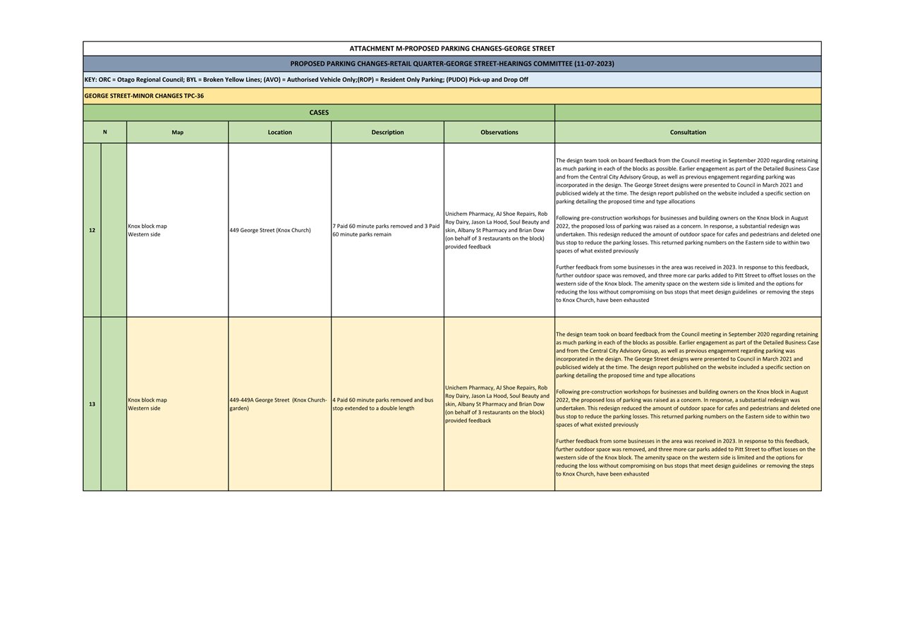
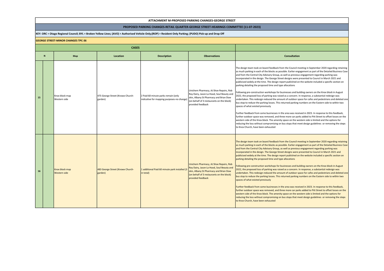
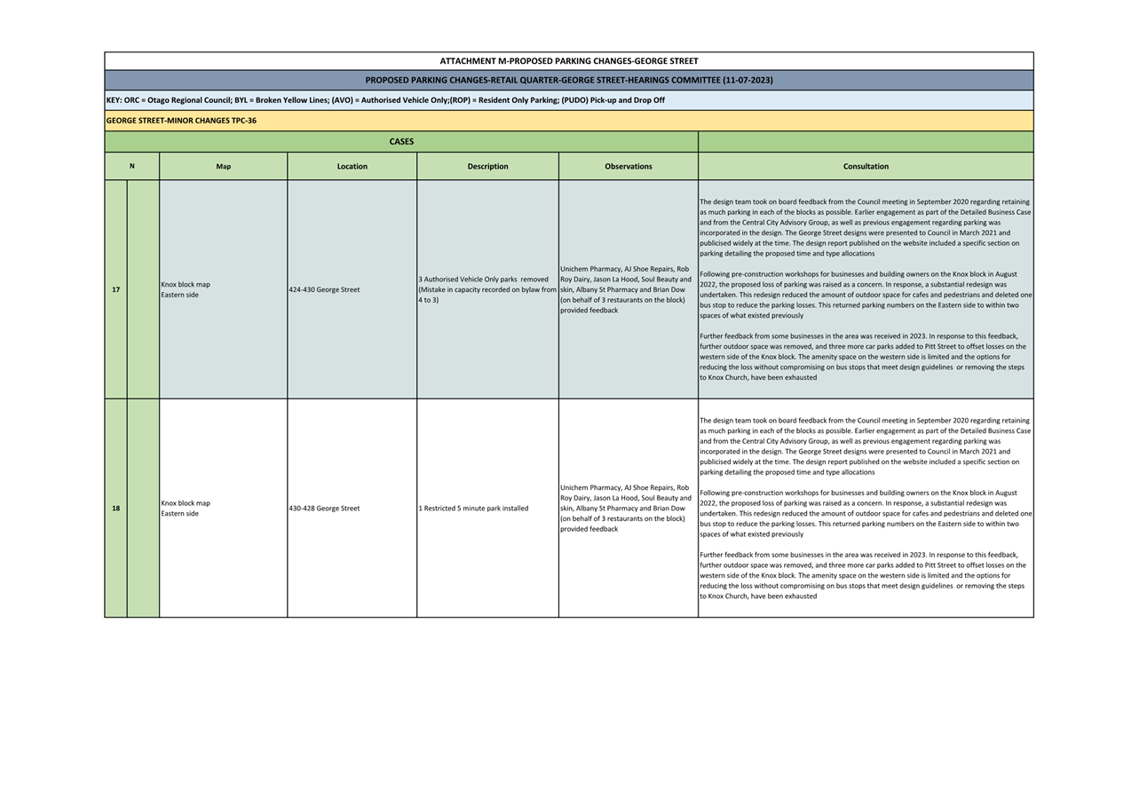
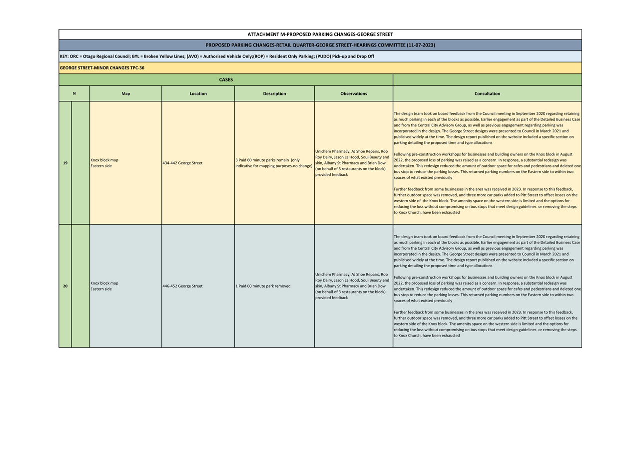
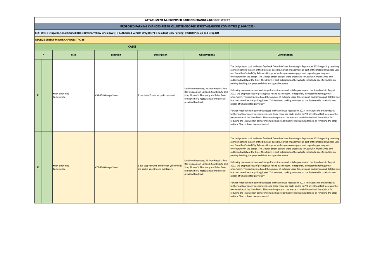
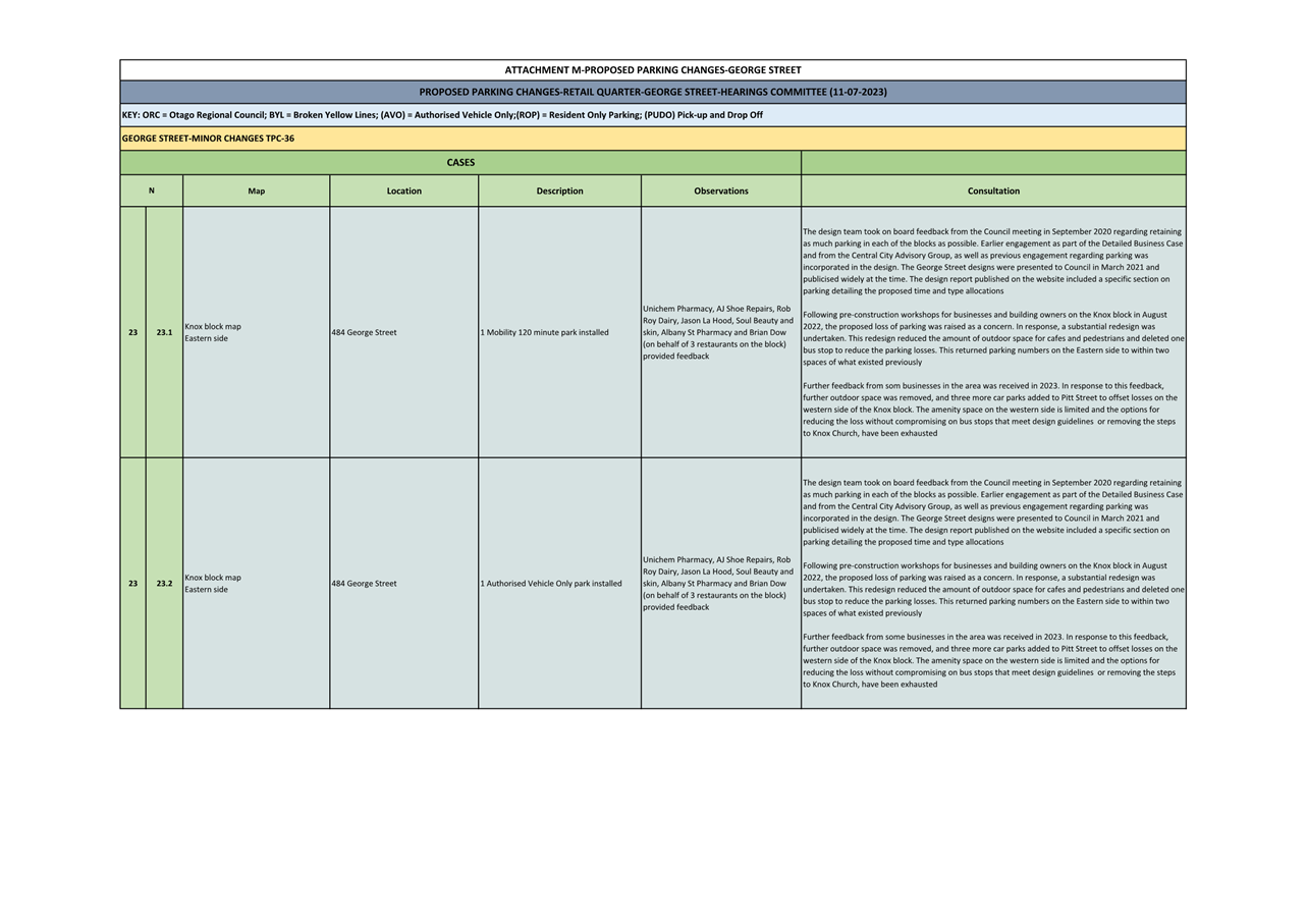
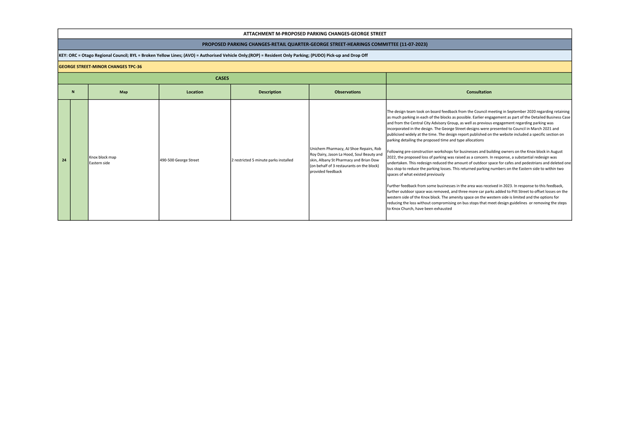
General parking, which include requests from the
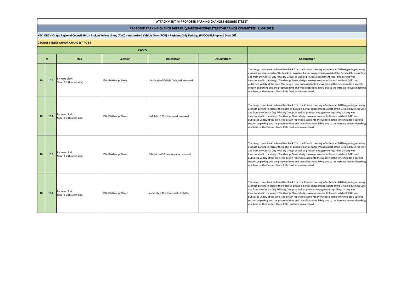
public to change parking restrictions;
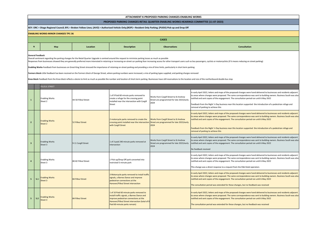
· Parking changes
related to the Albany Street Connection project as
part of the Shaping Future Dunedin Transport (SFDT) programme; and
· Parking changes
related to the Retail Quarter Upgrade. The George
Street designs were presented to Council in March 2021 and the design report
included a section on parking which detailed the proposed restrictions.
MINOR
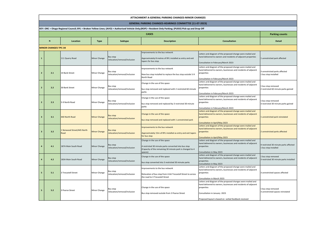
CHANGES-GENERAL PARKING CHANGES (Attachment A)
7 Council receives requests from individuals and businesses to change
parking restrictions. When considering these requests, officers assess a range
of factors including safety concerns, commuters’ needs, commercial
users’ needs, road width and topography, traffic flow, neighbouring on-street
parking spaces, visibility concerns and crash statistics. If a proposed change
is supported by officers, consultation is undertaken with affected residents,
businesses and property owners to demonstrate support for the requested change.
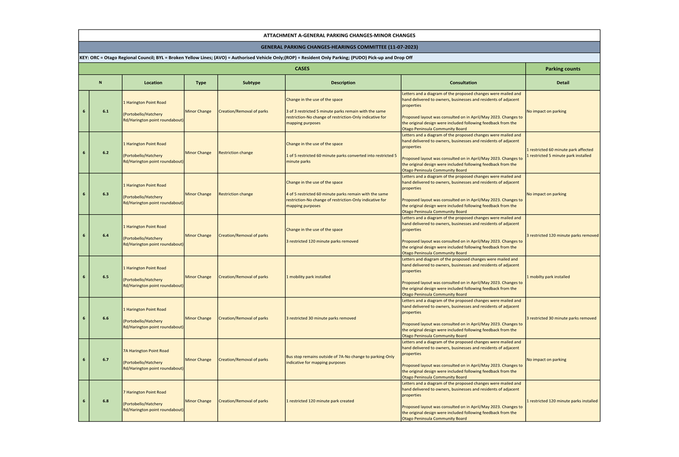
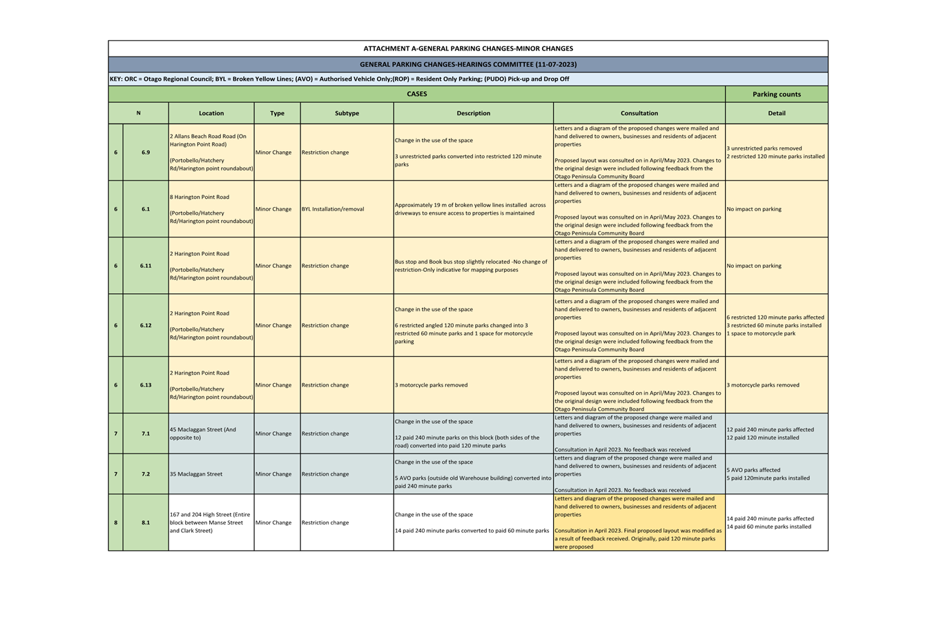
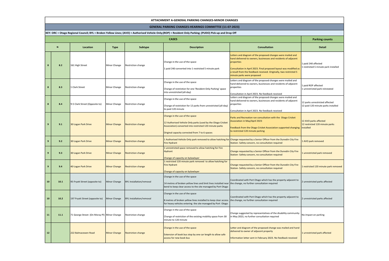
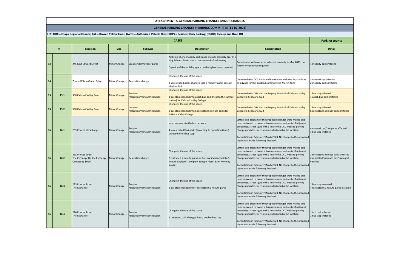
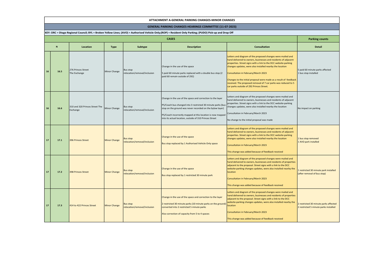
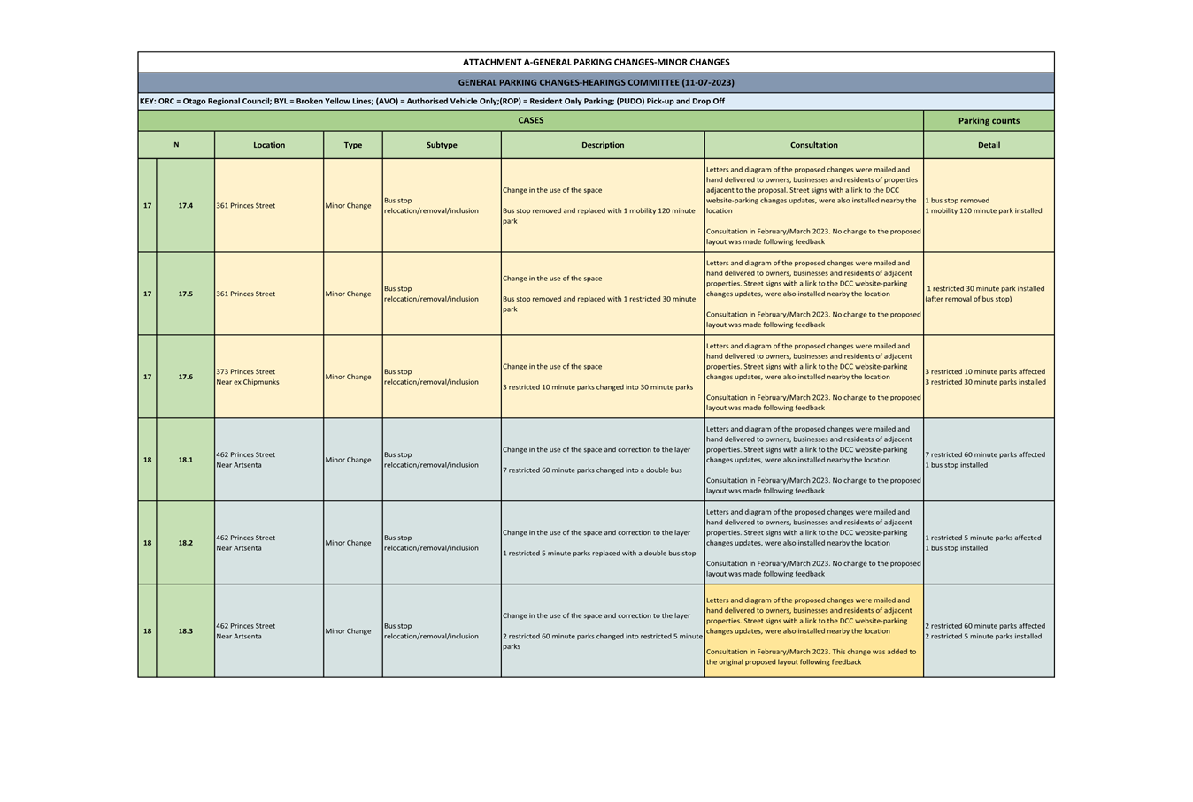
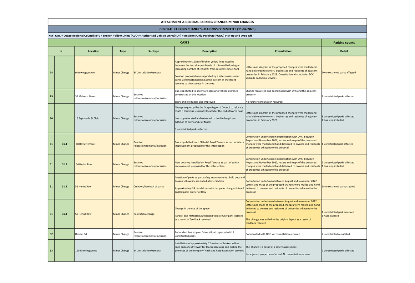
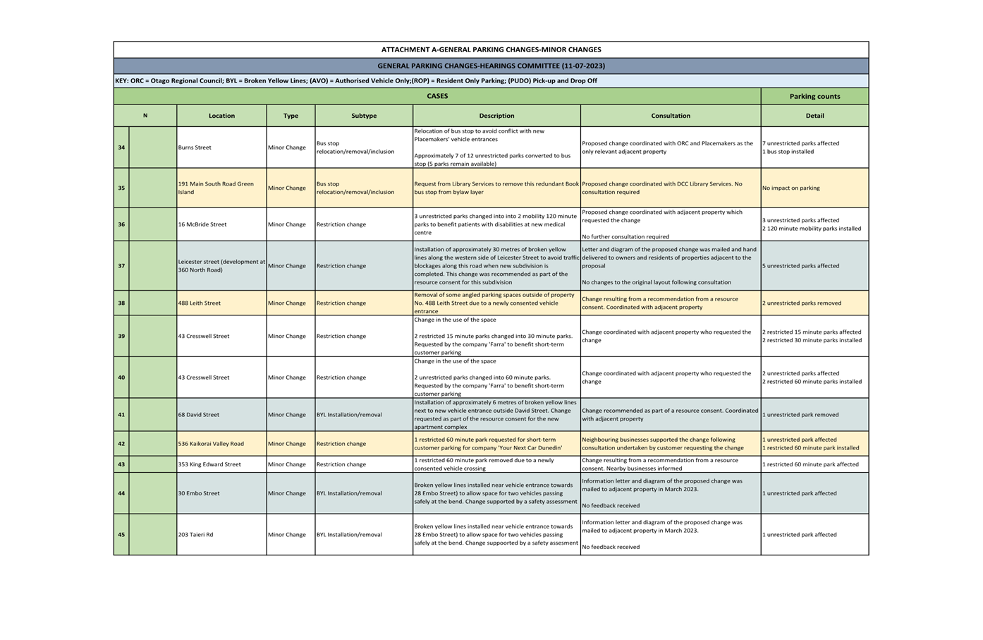
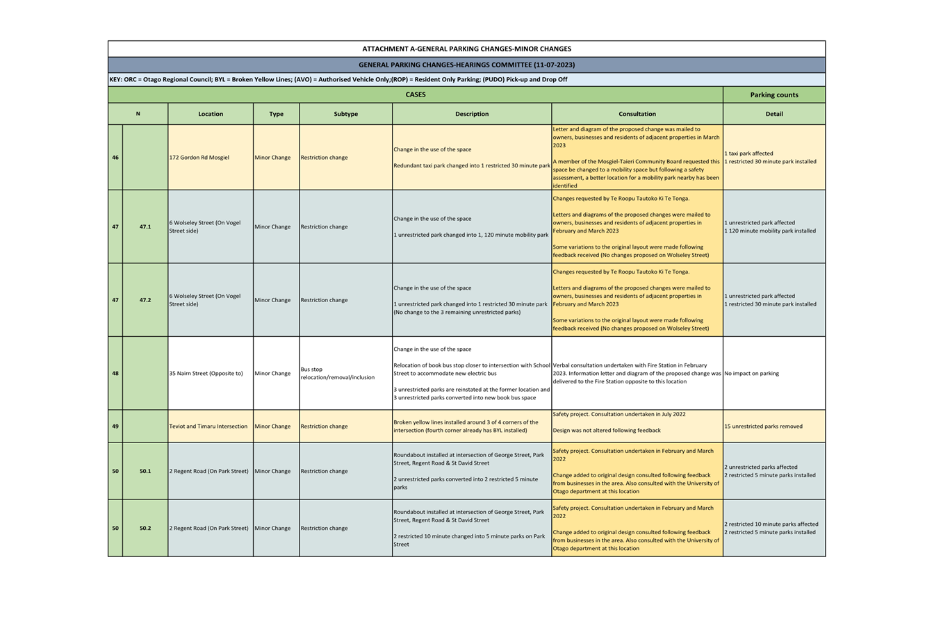
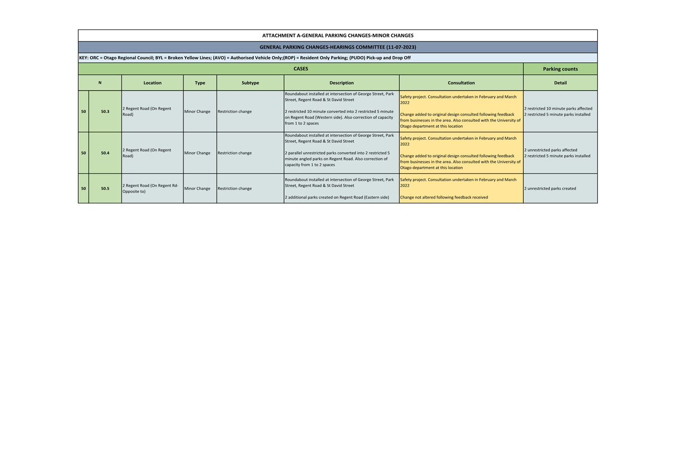
8 Recommended minor general parking changes are shown in
https://tinyurl.com/ParkingJuly2023
and are detailed in Attachments A (General parking
changes-Minor changes-TPC34) and C (General parking changes-Corrections-TPC35). The GIS
layer includes a bookmark feature which links the numbered cases presented in the tables of Attachment A and Attachment C, to their specific
location.
9 A
detailed summary of the consultation undertaken with
affected parties, including owners, residents
and businesses is presented in Attachment B. These include:
a) parking changes to improve safety, efficiency or access where appropriate engagement has been carried out with affected
parties
b) changes to improve the operation of the bus network
where appropriate engagement
with affected parties
has been carried
out by the Otago Regional Council (ORC).
Princes
Street - Bus network improvements
10 The proposed changes to Princes Street are detailed in Attachment A
and diagrams of the proposed changes are presented as Attachment D (Diagrams
Princes Street). These changes aim to improve south and northbound bus stops by
removing poorly spaced stops and introducing double length stops with entry and
exit tapers that are consistent with national guidelines. The removal and
consolidation of some stops will help with traffic flow by reducing the number
of times the bus merges with traffic on a busy road. Double length bus stops
near the CBD help avoid stacking issues and buses blocking the live traffic
lane. The new stop locations are more accessible (flat location, easier for
drivers to pull flush with the kerb) and easier to identify as paired stops (e.g.
north and southbound stops are opposite each other).
11 Four southbound bus stops, including three stops within a 200-metre
stretch of road, will be consolidated into two larger stops which is consistent
with the pairing of the northbound bus stops.
12 The single northbound stop at The Exchange (300 Princes Street) will
be relocated to the flat section of road near High Street (276 Princes Street)
and lengthened. This new stop location is a better pair with the southbound
stop. The double length stop will remove instances of buses stacking into the
live traffic lane.
13 The northbound stop located outside the derelict buildings along
Princes Street (398 Princes Street) will be relocated one block south and
extended to a double length stop.
14 The Otago Regional Council (ORC) data below shows the usage of the
bus stops mentioned. It is expected that passenger numbers from the stops being
removed will be distributed across the improved neighbouring stops.
|
|
Southbound
|
Northbound
|
|
|
265 Princes St (John Wickliffe)
|
283 Princes St
(Silver Fern) *
|
373 Princes St
(Smile Co Dental) *
|
449 Princes St
(Opposite to Artsenta)
|
300 Princes St
(Fable Hotel)
|
398 Princes St
(Princes St Butcher)
|
|
Nov-22
|
Boarding
|
2160
|
606
|
694
|
369
|
1054
|
579
|
|
Disembarking
|
966
|
126
|
424
|
399
|
2341
|
1378
|
|
Dec-22
|
Boarding
|
1544
|
526
|
580
|
367
|
808
|
351
|
|
Disembarking
|
766
|
154
|
389
|
324
|
1864
|
931
|
|
Jan-23
|
Boarding
|
1562
|
573
|
608
|
238
|
763
|
305
|
|
Disembarking
|
724
|
221
|
292
|
254
|
1745
|
915
|
|
Feb-23
|
Boarding
|
2178
|
623
|
724
|
368
|
989
|
430
|
|
Disembarking
|
860
|
151
|
488
|
348
|
2149
|
1167
|
|
Mar-23
|
Boarding
|
2422
|
618
|
849
|
376
|
1145
|
532
|
|
Disembarking
|
1038
|
167
|
552
|
470
|
2384
|
1336
|
|
Apr-23
|
Boarding
|
1702
|
516
|
587
|
305
|
847
|
403
|
|
Disembarking
|
764
|
120
|
364
|
383
|
1853
|
1047
|
|
|
* To be
removed
|
|
|
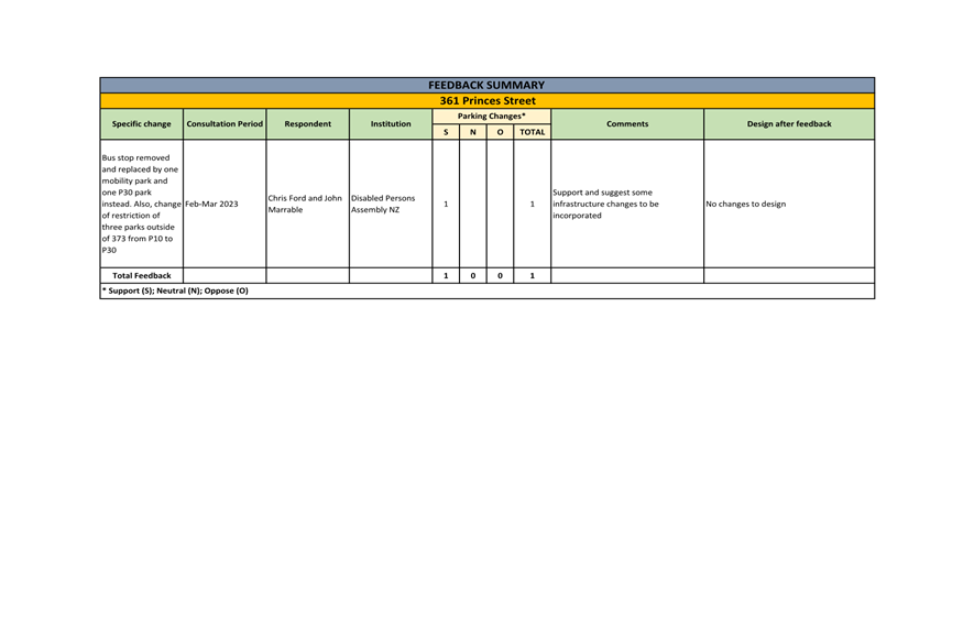
15 Consultation
for these changes was undertaken from 20 February to 17 March 2023. Letters
with the diagrams of the changes were hand delivered to all owners, residents
and businesses in the relevant areas. Signs advising of the proposed changes
were installed on the affected blocks to encourage the public to provide
feedback through the DCC website. Details the feedback received is provided in
Attachment B.
Road Safety
Improvements
16 The
road safety improvements programme for 2022 and 2023 included four trial
roundabouts. Two of the roundabouts have impacted parking. These were consulted
on as part of the project and have resulted in parking changes that are now
incorporated to the bylaw layer. The roundabouts are:
· Intersection of
Timaru and Teviot Streets
· Intersection of
George, Park and St David Streets, and Regent Road
If the trials are successful, these
roundabouts will be made permanent. As the trials may be in place for several
years, changes are proposed to the bylaw layer to support enforcement.
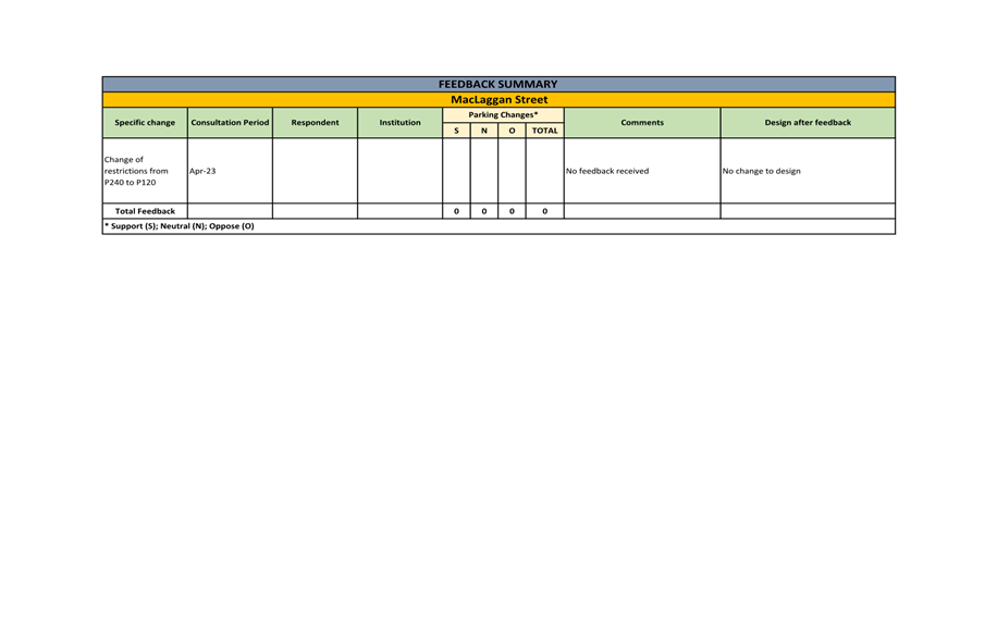
High Street
and MacLaggan Street
17 Changes
are proposed to the parking on some sections of High Street and MacLaggan
Street. These changes arise from the closure of the centre city Warehouse, and
a request from a local business for shorter term parking restrictions. The
proposed changes see a reduction in paid four-hour parking in this area and an
increase in one and two hour paid parking.
Gladstone
Road
18 Approximately 90 metres of broken yellow lines are proposed to be
added on Gladstone Road. Residents raised concerns about unsafe parking on the
street and Waste and Environmental Solutions advised that parking on the street
is making rubbish collection problematic. A safety assessment by a
transportation engineer supports the need to restrict parking on this section
of Gladstone Road. A diagram of the area is at Attachment F.
Newington
Avenue
19 Approximately 150 metres of broken yellow lines are proposed to be
added on Newington Avenue after residents raised concerns about unsafe parking
on the street. These concerns were supported by a safety assessment by a
transportation engineer. A diagram of the area is at Attachment G.
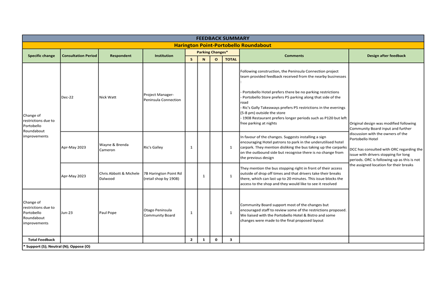
Portobello Roundabout
20 Several parking changes are proposed for Portobello following the
installation of a new roundabout and intersection improvements as part of the
Peninsula Connection project. These changes will be monitored, and further
changes may be made in the future if community feedback is received.
Parking counts for General Parking
Changes
21 In total, it is proposed there will be a net loss of 73 parks
reallocated, 35 of which correspond to safety improvements on Gladstone Road
and Newington Road, eight are dedicated to bus network improvements and the
remaining 30 are reallocated to other amenity improvements (Table A below).
These are predominantly in residential areas. A detail of this distribution can
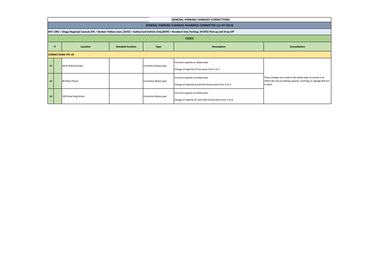
be observed by zones in Table B below.
There will be a net removal of 9 bus stops
across the city.
|
Table A-Parking counts
|
|
|
Net
|
|
Carparks
|
-73
|
|
CP to BS *
|
-8
|
|
|
|
|
Bus Stops
|
-9
|
|
* Carparks (CP) lost to or gained from
bus stops (BS)
|
|
Table B-Distribution by zones
|
|
Zone
|
Net
|
|
Retail Quarter
|
0
|
|
Cultural Entertainment Quarter
|
0
|
|
Warehouse Precinct
|
0
|
|
Creative Quarter
|
-15
|
|
Tertiary & Medical Quarter
|
0
|
|
Other
|
-58
|
|
Total
|
-73
|
General Parking Changes-Corrections to
the Traffic and Parking Bylaw (Attachment C)
22 Corrections of parking restrictions to the database are detailed in
Attachment C. They do not change current parking restrictions but include
corrections to the database that have been made to accurately reflect the parking restrictions
which are on the ground.
PARKING CHANGES-ALBANY STREET CONNECTION
PROJECT (Attachment H)
23 Recommended parking changes to parking restrictions for the Albany
Street Connection project are shown in https://tinyurl.com/ParkingJuly2023
and a detail of the changes is
presented as Attachment H (Albany Street Connection-Proposed parking
changes-TPC32). The GIS layer includes a bookmark feature which links the numbered
cases presented in the table of Attachment H, to their specific location on the GIS layer.
24 Maps relevant to Albany Street Connection project, are shown as Attachment I
(Albany Street Connection maps).
25 The Albany Street Connection project is part of the Shaping Future
Dunedin Transport (SFDT) programme. It aims to improve pedestrian
safety on Albany Street and provide a safe and attractive east-west cycle route
that connects the Harbour Cycleway with the cycle lanes on State Highway One,
the Tertiary Precinct and the CBD.
26 As part of this project, DCC has been working with the ORC to simplify
the tertiary bus routes and improve bus stops. To improve services in this area
bus stops on Union Street East and adjacent streets need to be moved.
27 To make the area safer and more accessible and to improve pedestrian
safety generally, crossing points on Union Street East and Harbour Terrace are
proposed. These improvements will support the 30 km/h speed limit that Council
approved in early 2023 through the Interim Speed Management Plan.
28 Consultation on the proposed changes was undertaken in May/June
2022. Detail of the feedback received is presented as Attachment J (Albany
Street Connection-Feedback Summary).
29 As a direct result of feedback, a number of changes were made to the
2022 concept design, and these are listed here:
https://www.dunedin.govt.nz/services/roads-and-footpaths/projects/connecting-dunedin-projects/albany-street-connection
30 The parking changes proposed also provide pedestrian and safety
improvements on Union Street and adjacent streets (Harbour Terrace, parts of
Forth and Clyde Streets).
31 A
second round of targeted consultation relating to the Albany Street cycleway
closed on the 26 June 2023, and feedback received is being considered.
Consultation documents can be viewed at:
https://www.dunedin.govt.nz/services/roads-and-footpaths/projects/connecting-dunedin-projects/albany-street-connection
Parking counts-Albany Street Connection
32 The Albany Street Connection project requires a net loss of 36 parks
be reallocated to road improvements. Nine of these are allocated to improve the
bus network and the rest to amenity improvements such as upgrading pedestrian
crossings and enhancing intersections.
33 There will be four new bus stops in the tertiary precinct.
|
Net
|
|
Carparks
|
-36
|
|
CP to BS *
|
-9
|
|
|
|
|
Bus Stops
|
4
|
|
* Carparks (CP)lost to or gained from
bus stops (BS)
|
PARKING CHANGES- RETAIL QUARTER UPGRADE (Attachments K and M)
34 Recommended parking changes relating the Retail
Quarter Upgrade are shown in https://tinyurl.com/ParkingJuly2023 and
detailed in Attachment K and Attachment M. The GIS layer includes a bookmark
feature which links the numbered cases presented in the tables of Attachments K
and M, to their specific location on the GIS layer.
35 Maps of the changes relevant to the Retail Quarter Upgrade, are
shown as Attachment
L and Attachment N.
36 The changes have been designed to:
· improve safety for
vulnerable road users, particularly at intersections.
· increase amenity
· improve traffic flow
· enable more
efficient use of Great King Street by buses
· expand bus stop
lengths
· provide better
access to off-street parking.
37 There are adjustments to car parking in the CBD as a result of the
Retail Quarter Upgrade, including losses in some areas. In the hospital block
of Great King Street there is a small increase in the number of car parks.
38 Parking loss was raised as a concern following pre-construction
workshops with businesses and building owners regarding the Knox block in August
2022. In response, a redesign was undertaken. Further feedback from nearby
businesses was received in 2023. In response to this feedback, further outdoor
space was removed, and three more car parks were added to Pitt Street to offset
losses on the western side the Knox block. There is still some opposition to
the loss of parking on the Knox block, centred on the northbound double bus
stop.
39 Consultation for the Retail Quarter Upgrade was undertaken as part
of the project. Engagement as part of the Detail Business Case and from the
Central City Advisory Group as well as previous engagement regarding parking,
were incorporated in the design. The George Street designs were presented to
Council in March 2021. The design report released onto the website at the time
includes a specific section on parking. Additional pre-construction workshops
related to the Knox block were undertaken and resulted on a substantial
redesign of this block.
40 The
changes related to the Enabling Works were consulted in early April 2022.
Parking counts- Retail Quarter Upgrade
and Enabling Works
41 The Retail Quarter includes a loss of seven parks related to the
enabling works, a gain of one park for the Farmers block, and a net loss of 12
parks on the Knox block to improve safety and amenity.
|
Before
|
After
|
Net
|
|
Enabling works
|
40
|
33
|
-7
|
|
Farmers block
|
16
|
17
|
1
|
|
Knox block
|
32
|
20
|
-12
|
|
Including additional car parks gained in
side streets to offset the loss on the Knox block
|
OPTIONS
42 Two options
are proposed. The recommended option is to proceed
with some or all of the proposed changes to
the GIS database, and option
two is maintaining the status quo.
Option One – Approve some or all of the proposed
changes (recommended option)
43 That
the Committee approves some or all of the proposed changes to the traffic and
parking controls database.
Advantages
· Improves safety, efficiency and access on the transport network by:
- enabling property access by prohibiting obstructive parking, making existing parking
controls clearer, and providing
for access to new driveways
- providing an improved
and enforceable framework
of parking restrictions
- providing appropriate length
of parking stay according to the surrounding land uses
- increasing visibility at intersections.
· Improves public transport infrastructure by providing bus stops to
support bus services and enables buses to safely enter and exit bus stops.
· Contributes to achieving an integrated, affordable responsive,
effective and safe transport network.
Disadvantages
· Costs of installation.
Option Two – Status Quo
44 Retain the parking restrictions without amendment.
Advantages
· Council resources can be allocated to other transport
projects.
Disadvantages
· Does not improve
efficiency and access
to the transport network.
· Does not improve safety
or reduce conflict
points.
· Does not contribute to the Integrated Transport Strategy goals.
NEXT STEPS
45 If the Committee recommends the changes to traffic and parking
controls, a report of the proposed
changes will be brought before Council for approval.
46 If Council approves
the recommended changes
to parking restrictions, these will be implemented
through appropriate signs and road markings and restrictions will be enforced under the Traffic and Parking Bylaw.
Signatories
|
Author:
|
Paula Barragan - Policy Analyst -
Transport Regulation
|
|
Authoriser:
|
Jeanine Benson - Group Manager Transport
Robert West - General Manager Corporate
and Quality
|
Attachments
|
|
Title
|
Page
|
|
⇩a
|
General
Parking Changes-Minor Changes TPC34.
|
21
|
|
⇩b
|
General
parking changes-Feedback summary
|
35
|
|
⇩c
|
General
Parking Changes-Corrections TPC35
|
81
|
|
⇩d
|
General
Parking Changes zones
|
83
|
|
⇩e
|
Diagrams
Princes Street
|
84
|
|
⇩f
|
Diagram
Gladstone Road
|
87
|
|
⇩g
|
Diagram
Newington Avenue
|
88
|
|
⇩h
|
Albany
Street Connection-Proposed parking changes-TPC32
|
89
|
|
⇩i
|
Albany
Street Connection maps
|
95
|
|
⇩j
|
Albany
Street Connection-Feedback summary 2022
|
97
|
|
⇩k
|
Enabling
Works-Proposed parking changes TPC36
|
119
|
|
⇩l
|
Enabling
Works maps
|
124
|
|
⇩m
|
George
Street-Proposed parking changes TPC36
|
134
|
|
⇩n
|
George
Street maps
|
146
|
|
SUMMARY OF CONSIDERATIONS
|
|
Fit
with purpose of Local Government
This decision enables democratic local
decision making and action by, and on behalf of communities.
This decision promotes the social and
economic well-being of communities in the present and for the future.
|
|
Fit
with strategic framework
|
|
Contributes
|
Detracts
|
Not applicable
|
|
Social Wellbeing Strategy
|
☒
|
☐
|
☐
|
|
Economic Development Strategy
|
☒
|
☐
|
☐
|
|
Environment Strategy
|
☐
|
☐
|
☒
|
|
Arts and Culture Strategy
|
☐
|
☐
|
☒
|
|
3 Waters Strategy
|
☐
|
☐
|
☒
|
|
Spatial Plan
|
☐
|
☐
|
☒
|
|
Integrated Transport Strategy
|
☒
|
☐
|
☐
|
|
Parks and Recreation Strategy
|
☐
|
☐
|
☒
|
|
Other strategic projects/policies/plans
|
☒
|
☐
|
☐
|
Improvements to traffic and parking
restrictions supports a safe, efficient and accessible transport network, and supports the social and economic wellbeing of Dunedin communities.
|
|
Māori
Impact Statement
Mana whenua have expressed support for a
safe and efficient transport network.
|
|
Sustainability
Parking
control changes improve
efficiency and access
to the transport network, which contribute to sustainability
goals.
|
|
LTP/Annual
Plan / Financial Strategy /Infrastructure Strategy
There are no implications.
|
|
Financial
considerations
Costs for implementing the proposed changes
are covered by existing budgets.
|
|
Significance
The report is considered of low
significance in terms of the Council’s Significance and Engagement Policy.
|
|
Engagement
– external
There has been engagement with
affected parties.
|
|
Engagement
- internal
There has been engagement with transport and parking services staff.
|
|
Risks:
Legal / Health and Safety etc.
Many of the proposed changes aim to
improve safety of vulnerable users of the transport network.
|
|
Conflict
of Interest
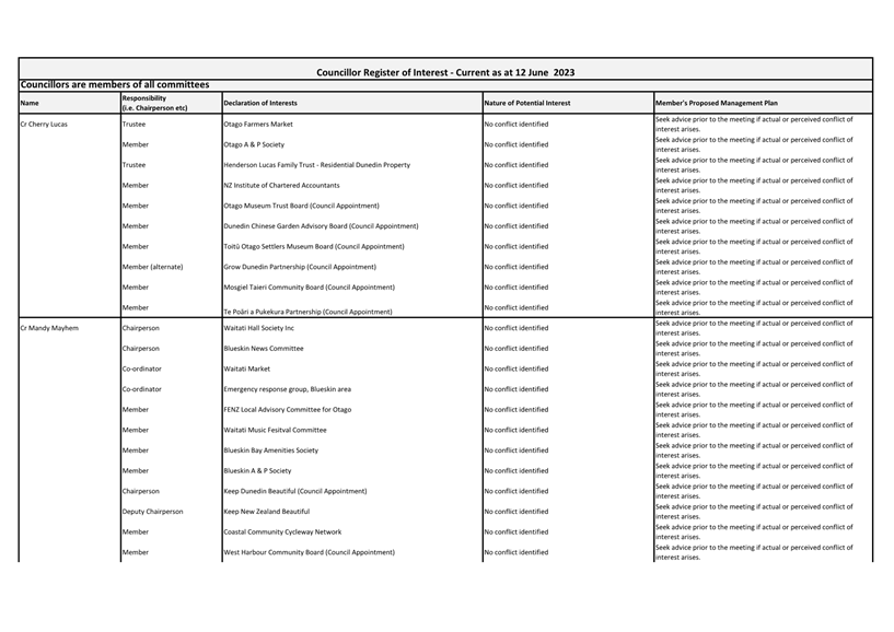
There are no known conflicts of interest.
|
|
Community
Boards
Otago Peninsula Community Board has been
informed of the relevant proposal (Harington Point Road). Staff have liaised
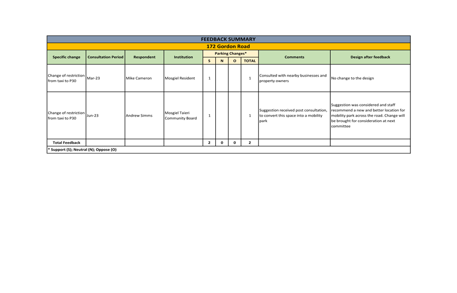
with the Chair of the Mosgiel-Taieri Community Board for the change at 172
Gordon Road.
|